
Inwood is a hamlet and census-designated place (CDP) in Nassau County, New York, United States. The population was 9,792 at the 2010 census.
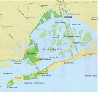
Rockaway Inlet is a strait connecting Jamaica Bay, wholly within New York City, with the Atlantic Ocean. It separates the Rockaway Peninsula in Queens from the Floyd Bennett Field in Brooklyn.

The Far Rockaway Branch is an electrified rail line and service owned and operated by the Long Island Rail Road in the U.S. state of New York. The branch begins at Valley Interlocking, just east of Valley Stream station. From Valley Stream, the line heads south and southwest through southwestern Nassau County, ending at Far Rockaway in Queens, thus reentering New York City. LIRR maps and schedules indicate that the Far Rockaway Branch service continues west along the Atlantic Branch to Jamaica. This two-track branch provides all day service in both directions to the Atlantic Terminal in Brooklyn, with limited weekday peak service to/from Penn Station in Midtown Manhattan. During peak hours, express service may bypass Jamaica station.

Hog Island was the name of two islands near Long Island, New York until the 1890s. One is the present day Barnum Island, which includes the villages of Island Park and Harbor Isle in Nassau County. The other was a mile-long (1600 m) barrier island that existed to the south of Rockaway Beach in Queens before being mostly destroyed by the 1893 New York hurricane and completely lost to erosion and storm damage by 1902.

Hammels is an area within Rockaway Beach on the Rockaway Peninsula in the New York City borough of Queens. It is located west of Arverne and east of Seaside, and is centered on Beach 84th Street. Its main thoroughfare is Beach Channel Drive. The A train travels through the neighborhood on the IND Rockaway Line. The Hammel Houses, a public housing project built in 1954, is located in the neighborhood.

Rockaway Beach Boulevard, opened in 1886, was the first major east-west thoroughfare on the Rockaway Peninsula in the Borough of Queens in New York City. Much of its route parallels the Rockaway Freeway and the IND Rockaway Line above the Freeway. The boulevard first forks off at its eastern end from Beach Channel Drive at Beach 35th Street in Edgemere and merges once again with Beach Channel Drive by Jacob Riis Park shortly before the Marine Parkway–Gil Hodges Memorial Bridge.
The Rockaway Freeway is a road in the New York City borough of Queens that was created from the old right-of-way of the Long Island Rail Road Rockaway Division in 1941–1942 as part of the project to eliminate grade crossings within New York City. The railroad line itself was elevated over the new automotive route, and was incorporated into the New York City Subway system as the IND Rockaway Line in June 1956.
Curley's Atlas Hotel and Baths was a long-standing institution in the Rockaway Park neighborhood of Queens in New York City. The hotel was founded in 1876 by John J. Curley on the beachfront at present-day Beach 102nd Street, in the neighborhood now known as Rockaway Beach or "Irishtown". The hotel was moved to its larger longer-lasting site at Beach 116th Street in 1900.

The East Rockaway Inlet is an arm of the Atlantic Ocean which separates the Rockaway Peninsula from the barrier island which includes the Nassau County, New York communities of Atlantic Beach, Long Beach and Lido Beach.

Rockaway Parkway is a major commercial street in the Canarsie neighborhood of Brooklyn, New York.

Roxbury is a community on the Rockaway Peninsula in the New York City borough of Queens. The neighborhood is just west of the Marine Parkway–Gil Hodges Memorial Bridge and adjoins Fort Tilden. It is an inholding within the borders of the Breezy Point Unit of Gateway National Recreation Area, of the National Park System.

Naval Air Station Rockaway adjoined Fort Tilden on the western portion of the Rockaway Peninsula in the New York City borough of Queens. It was established on transferred municipal property in 1917 during American involvement in World War I, and was demolished in 1930 to make way for Jacob Riis Park. Operations were moved across the inlet to a hangar in the municipal Floyd Bennett Field, which itself was sold to the federal government in 1941 and made Naval Air Station New York. NAS New York was decommissioned in 1972 and is now a part of the Gateway National Recreation Area, as are Fort Tilden and Jacob Riis Park.

The Heights of Guan, a variant of "Gowanus", was the New York colonial era name given to a series of hills which extend in a ridge along the western portion of Long Island. The ridge extends in an east northeast direction starting from Bay Ridge, Brooklyn with hills of varying heights of 100 to 150 feet (30-45m), with the southern slope of the ridge having a relatively steep drop and the rear, a more gradual slope. The ridge marks the terminal moraine of the Wisconsin Glacier that formed the North Shore of Long Island, south of the ridge is the outwash plain bordered by the Atlantic Ocean.

Howard was a former Long Island Rail Road station on the Rockaway Beach Branch. Located on marshland along the coast of Jamaica Bay south of the "WD Tower" near Hawtree Creek, it had no fixed address, and was south of what is today 165th Avenue, evidently within the Gateway National Recreation Area's Hamilton Beach Park.

The Rockaway Hunting Club is a country club and sporting venue established in 1878 in Cedarhurst, New York on Long Island. In 1893 the original clubhouse was lost in a fire. In 1917 the golf course was expanded from 9 holes to 18 holes.

Kohlreiter Square is an 8.6-acre public green space located in the Arverne neighborhood on Rockaway Peninsula in Queens, New York. It located along the north side of Rockaway Freeway between Beach 67th and Beach 69th Streets. The park honors two generations of civic activists, Nathan A. Kohlreiter (1880–1961) and his son Fred Kohlreiter (1913–1990) who contributed to the political and social fabric of the neighborhood.
Walter J. Wetzel Triangle is small park bound by Cohancy Street, 156th Avenue, 99th Street, and 157th Avenue, in the Howard Beach neighborhood of Queens, New York City.
Reverend Lawrence E. Lynch Memorial Triangle is a 0.138 acres park located at the intersection of Rockaway Boulevard, Atlantic Avenue, and 81st Street in Ozone Park, Queens, New York City. The neighborhood's streets were laid out in a grid of streets and avenues at the turn of the 20th century while Rockaway Boulevard cuts diagonally through the grid on its route between Cypress Hills and Woodmere. Triangular intersections that were too small to be developed were designated as public plazas, including this one. In 1949, the city designated this triangle in memory of Lynch, a Woodhaven resident who served as a chaplain in the Pacific Theater during World War Two.

Tribute Park is a 0.83-acre (0.34 ha) public green space in the Rockaway Park neighborhood of Queens, New York City. It is located at the corner of Beach Channel Drive and Beach 116th Street, facing Jamaica Bay.