Related Research Articles

Kiribati, officially the Independent and Sovereign Republic of Kiribati, is an island country in the Micronesia subregion of Oceania in the central Pacific Ocean. Its permanent population is over 119,000 as of the 2020 census, with more than half living on Tarawa atoll. The state comprises 32 atolls and one remote raised coral island, Banaba. Its total land area is 811 km2 (313 sq mi) dispersed over 3,441,810 km2 (1,328,890 sq mi) of ocean.
In the mythology of Kiribati, Auriaria is a red-haired giant chieftain and demigod from Samoa.
In the Micronesian mythology of Kiribati Uekera is a tree that reaches to the heavens; Te Kaintikuaba which is translated as the "tree of life" or "tree of knowledge" in Kiribati legend. It is said to have been planted in Buariki village in North Tarawa by Nei Tekanuea. The creation story is that spirits who lived in Te Kaintikuaba in Samoa, migrated northward carrying branches from the tree and created the islands of Tungaru. It is the inspiration for the name of the Kiribati weekly newspaper, Te Uekera.

The Gilbert Islands are a chain of sixteen atolls and coral islands in the Pacific Ocean, about halfway between Papua New Guinea and Hawaii. They constitute the main part of the nation of Kiribati.
Spring, also known as springtime, is one of the four temperate seasons, succeeding winter and preceding summer. There are various technical definitions of spring, but local usage of the term varies according to local climate, cultures and customs. When it is spring in the Northern Hemisphere, it is autumn in the Southern Hemisphere and vice versa. At the spring equinox, days and nights are approximately twelve hours long, with daytime length increasing and nighttime length decreasing as the season progresses until the Summer Solstice in June and December.

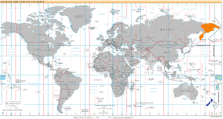
The International Date Line (IDL) is an internationally accepted demarcation of the surface of Earth, running between the South and North Poles and serving as the boundary between one calendar day and the next. It passes through the Pacific Ocean, roughly following the 180.0° line of longitude and deviating to pass around some territories and island groups. Crossing the date line eastbound decreases the date by one day, while crossing the date line westbound increases the date.

The Pacific Islands Forum (PIF) is an inter-governmental organization that aims to enhance cooperation among countries and territories of Oceania, including formation of a trade bloc and regional peacekeeping operations. It was founded in 1971 as the South Pacific Forum (SPF), and changed its name in 1999 to "Pacific Islands Forum", so as to be more inclusive of the Forum's Oceania-spanning membership of both north and south Pacific island countries, including Australia. It is a United Nations General Assembly observer.

Butaritari is an atoll in the Pacific Ocean island nation of Kiribati. The atoll is roughly four-sided. The south and southeast portion of the atoll comprises a nearly continuous islet. The atoll reef is continuous but almost without islets along the north side. Bikati and Bikatieta islets occupy a corner of the reef at the extreme northwest tip of the atoll. Small islets are found on reef sections between channels on the west side. The lagoon of Butaritari is deep and can accommodate large ships, though the entrance passages are relatively narrow. It is the most fertile of the Gilbert Islands, with relatively good soils and high rainfall. Butaritari atoll has a land area of 13.49 km2 (5.21 sq mi) and a population of 3,224 as of 2015. During World War II, Butaritari was known by United States Armed Forces as Makin Atoll, and was the site of the Battle of Makin. Locally, Makin is the name of a separate but closest atoll, 3 kilometres to the northeast of Butaritari, but close enough to be seen. These two atolls share a dialect of the Gilbertese language.

Gilbertese or taetae ni Kiribati, also Kiribati, is an Austronesian language spoken mainly in Kiribati. It belongs to the Micronesian branch of the Oceanic languages.

Arorae is an atoll in Kiribati located near the equator. Arorae is the southernmost island in the Gilbert Islands group. It has a population of just over a thousand inhabitants on 9.5 square kilometres.
UTC+13:00 is an identifier for a time offset from UTC of +13:00. Because it does not contain any land in the Northern Hemisphere, this time zone is exclusive to the Southern Hemisphere.
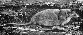
The hero shrew, also known as the armored shrew, is a large shrew native to the Congo Basin of Africa. Its features are typical of a white-toothed shrew − short legs, slender snout, dense fur − except for a highly unusual spinal column. It has corrugated interlocking vertebrae that are unique among mammals except for its sister species, Thor's hero shrew. This unique adaptation allows the animal to bear a huge amount of weight on its back − 72 kg (159 lb) according to an expedition team.

Beru is an atoll in the Southern Gilbert Islands in the Pacific Ocean, part of the Republic of Kiribati. Beru was previously known as Eliza, Francis Island, Maria, Peroat, Peru Island or Sunday. It's part of a larger reef with the Nuka Lagoon at its center, and the nearest island is Nikunau. The Tabiang Lagoon is present in the north. Beru is home to 2,051 inhabitants. Due to sea surges, the atoll is experiencing coastal erosion along with damages to seawalls.
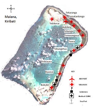
Maiana is an atoll in Kiribati and is one of the Central Gilbert Islands. Maiana is 44 kilometres (27 mi) south of the capital island of South Tarawa and has a population of 1,982 as of 2015. The northern and eastern sides of the atoll are a single island, whilst the western edge consists of submerged reefs and many uninhabited islets, all surrounding a lagoon. The atoll is 14 kilometres (8.7 mi) long and is very narrow, with an average width of less than 1 kilometre (0.62 mi) and a total land area of 16.72 square kilometres (6.46 sq mi).

Marakei is a small atoll in the North Gilbert Islands. It consists of a central lagoon with numerous deep basins, surrounded by two large islands separated by two narrow channels. The atoll covers approximately 40 square kilometres (15 sq mi).

Nikunau is a low coral atoll in the Gilbert Islands that forms a council district of the Republic of Kiribati. It consists of two parts, with the larger in the northwest, joined by an isthmus about 150 metres (490 ft) wide.
Micronesian mythology comprises the traditional belief systems of the people of Micronesia. There is no single belief system in the islands of Micronesia, as each island region has its own mythological beings.

Makin is the name of an atoll, chain of islands, located in the Pacific Ocean island nation of Kiribati. Makin is the northernmost of the Gilbert Islands, with a population of 1,990.
The Kiribati Uniting Church (KUC) is a united Protestant Christian denomination in Kiribati. With approximately 25,000 members, and 136 congregations, the KUC is the second-largest religious group in Kiribati and accounts for approximately 21 percent of the population of the country.

India and Kiribati established diplomatic relations in 1985. The High Commission of India in Suva, Fiji is concurrently accredited to Kiribati. Kiribati maintains an Honorary Consulate in New Delhi.
References
| | This article relating to a myth or legend from Oceania is a stub. You can help Wikipedia by expanding it. |
| | This Republic of Kiribati-related article is a stub. You can help Wikipedia by expanding it. |