La Cienega/Jefferson station

Last updated

La Cienega/Jefferson
LACMTA Circle E Line.svg  
La Cienega-Jefferson station - November 2015.jpg
La Cienega/Jefferson station platform, November 2015
General information
Location5664 West Jefferson Boulevard
Los Angeles, California
Coordinates 34°01′34″N118°22′20″W / 34.0260°N 118.3721°W / 34.0260; -118.3721
Owned by Los Angeles County Metropolitan Transportation Authority
Platforms1 island platform
Tracks2
Connections
Construction
Structure typeElevated
Parking476 spaces [1]
Bicycle facilities Racks and lockers [2]
AccessibleYes
History
OpenedOctober 17, 1875;148 years ago (1875-10-17)
RebuiltApril 28, 2012;11 years ago (2012-04-28)
Previous names Sentous; Cassirani Ranch
Services
Preceding station LAMetroLogo.svg Metro Rail Following station
Culver City
toward Santa Monica
E Line Expo/La Brea
toward Atlantic
Former services
Preceding station PE Bolt.svg Pacific Electric Following station
Culver Junction
towards Rustic Canyon
Air Line Airville
Location
La Cienega/Jefferson station

La Cienega/Jefferson station is an elevated light rail station on the E Line of the Los Angeles Metro Rail system. The station is over the intersection of La Cienega Boulevard and Jefferson Boulevard, after which the station is named, in the Baldwin Hills neighborhood of Los Angeles. [3]

Contents

The station briefly served as the western terminus of the E Line between the opening of the line on April 28, 2012, and the completion of the Culver City station on June 20, 2012. [4]

History

Sentous Packing Co. 1906 Sentous Packing Co 1906.jpg
Sentous Packing Co. 1906

La Cienega/Jefferson station was once named Sentous station when it was on the Air Line. The Louis Sentous meat packing facility was nearby; they used the Air Line to ship meat to downtown Los Angeles. [5] The Sentous Yard maintenance facility persisted long after the passenger station was gone; according to one history, it occupied "a portion of the right-of-way directly east of La Cienega, and spur tracks and sidings exist directly west of La Cienega". [6]

Originally a stop on the Los Angeles and Independence and Pacific Electric railroads, it closed on September 30, 1953, with the closure of the Santa Monica Air Line and remained out of service until re-opening on Saturday, April 28, 2012. It was completely rebuilt for the opening of the Expo Line from little more than a station stop marker. Regular scheduled service resumed Monday, April 30, 2012.

Development of surrounding area

Los Angeles architect Eric Owen Moss proposed a 17-story glass ribbon office tower with underground parking within steps of this station. The tower began preparation in late 2018. [7] [8]

Condominiums and retail across from the station is currently under construction. It will be built by the Carmel Partners firm. [8] [9]

Service

Station layout

PlatformWestbound LACMTA Circle E Line.svg E Line toward Santa Monica (Culver City)
Island platform, doors will open on the left
Eastbound LACMTA Circle E Line.svg E Line toward Atlantic (Expo/La Brea)
GStreet LevelEntrance/Exit, faregates, ticket machines

A large parking structure located just south of the station provides "park-and-ride" access to the station.

Hours and frequency

E Line service hours are from approximately 4:30 a.m. and 11:45 p.m daily. Trains operate every 8 minutes during peak hours, Monday through Friday. During weekday midday and weekends from 9:00 a.m. to 7:00 p.m., trains run every 10 minutes. Night and early morning service is approximately every 20 minutes every day. [10]

Connections

As of December 10,2023, the following connections are available: [11]

Station artwork

The station's public art was created by Daniel Gonzales and titled Engraved in Memory consisting of pole-mounted glazed ceramic bas relief panels depicting the history of the Ballona Creek and Culver City areas. [12]

Related Research Articles

<span class="mw-page-title-main">La Cienega Boulevard</span> Highway in California

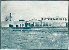
La Cienega Boulevard is a major north–south arterial road in the Los Angeles metropolitan area that runs from El Segundo Boulevard in Hawthorne to the Sunset Strip in West Hollywood to the north. It was named for Rancho Las Cienegas, literally "The Ranch Of The Swamps," an area of marshland south of Rancho La Brea.

<span class="mw-page-title-main">E Line (Los Angeles Metro)</span> Light rail line

The E Line is a 22-mile (35 km) light rail line in Los Angeles County, California, running between Santa Monica and East Los Angeles. It is one of the six lines in the Los Angeles Metro Rail system and is operated by the Los Angeles County Metropolitan Transportation Authority (Metro).

<span class="mw-page-title-main">North Hollywood station</span> Los Angeles Metro Rail station

North Hollywood station is a combined rapid transit and bus rapid transit (BRT) station in the Los Angeles Metro Rail and Metro Busway systems. It is the northwestern terminus of the B Line subway and eastern terminus of the G Line BRT route. It is located at the intersection of Lankershim Boulevard and Chandler Boulevard in the NoHo Arts District of the North Hollywood neighborhood in the San Fernando Valley of Los Angeles.

<span class="mw-page-title-main">Aviation/LAX station</span> Los Angeles Metro Rail station

Aviation/LAX station is an elevated light rail station on the C Line of the Los Angeles Metro Rail system. It is located over Aviation Boulevard, after which the station is named, near its intersection with Imperial Highway and south of Century Freeway in Los Angeles, California. It opened as part of the Green Line on August 12, 1995. The station was initially named Aviation Blvd/I-105, but in 2003, it was simplified and renamed Aviation/LAX to highlight its proximity to Los Angeles International Airport.

<span class="mw-page-title-main">Sepulveda station</span> Los Angeles Metro Busway station

Sepulveda station is a station on the G Line of the Los Angeles Metro Busway system. It is named after nearby Sepulveda Boulevard, which travels north-south and crosses the east-west busway route. Unique among G Line stations, Sepulveda's platforms are not located at the cross street, but rather about a block west of it. The station is in the Van Nuys neighborhood of the City of Los Angeles, in the central San Fernando Valley.

<span class="mw-page-title-main">Willow Street station</span> Los Angeles Metro Rail station

Willow Street station is an at-grade light rail station on the A Line of the Los Angeles Metro Rail system. The station is located adjacent to Long Beach Boulevard its intersection with Willow Street, after which the station is named, in the Wrigley neighborhood of Long Beach, California.

<span class="mw-page-title-main">Del Amo station</span> Los Angeles Metro Rail station

Del Amo station is an elevated light rail station on the A Line of the Los Angeles Metro Rail system. The station is located between Compton Creek and Santa Fe Avenue, and elevated over the intersection of Del Amo Boulevard, after which the station is named, in the Los Angeles County community of Rancho Dominguez and near the city of Carson.

<span class="mw-page-title-main">Lakewood Boulevard station</span> Los Angeles Metro Rail station

Lakewood Boulevard station is a below-grade light rail station on the C Line of the Los Angeles Metro Rail system. It is located in the median of Interstate 105, below Lakewood Boulevard, after which the station is named in the city of Downey, California.

<span class="mw-page-title-main">El Segundo station</span> Los Angeles Metro Rail station

El Segundo station is an elevated light rail station on the C Line of the Los Angeles Metro Rail system. It is located over El Segundo Boulevard, after which the station is named, near its intersection with Nash Street in El Segundo, California. It opened with the commencement of Green Line service on August 12, 1995. By 2024, El Segundo station will be served by the K Line after it gets extended to Redondo Beach and the C Line gets rerouted to LAX Airport at the future LAX/Metro Transit Center station.

<span class="mw-page-title-main">Atlantic station (Los Angeles Metro)</span> Los Angeles Metro Rail station

Atlantic station is an at grade light rail station on the E Line of the Los Angeles Metro Rail system. It is located at the intersection of Atlantic and Pomona Boulevards in East Los Angeles.

<span class="mw-page-title-main">Expo/Crenshaw station</span> Los Angeles Metro Rail station

Expo/Crenshaw station is a light rail station in the Los Angeles Metro Rail system located in the Jefferson Park neighborhood of Los Angeles at the intersection of Crenshaw and Exposition Boulevards. During construction, it was known as the Crenshaw station. The station is the transfer point between the E Line, which stops at two street-level platforms alongside Exposition Boulevard, and the K Line, which has its northern terminus at a single island platform under Crenshaw Boulevard.

<span class="mw-page-title-main">Expo/La Brea station</span> Los Angeles Metro Rail station

Expo/La Brea station is an elevated light rail station on the E Line of the Los Angeles Metro Rail system. The station is located over the intersection of Exposition Boulevard and La Brea Avenue, after which the station is named, in the West Adams neighborhood of Los Angeles.

<span class="mw-page-title-main">Culver City station</span> Los Angeles Metro Rail station

Culver City station is an elevated light rail station on the E Line of the Los Angeles Metro Rail system. The station is located on a dedicated right-of-way alongside Exposition Boulevard — between the intersection of Venice Boulevard and Robertson Boulevard on the west and the intersection of Washington Boulevard and National Boulevard on the east. The station is located in the city of Culver City, California, after which the station is named.

<span class="mw-page-title-main">Westwood/Rancho Park station</span> Los Angeles Metro Rail station

Westwood/Rancho Park station is an at-grade light rail station in the Los Angeles Metro Rail system located at the intersection of Westwood Boulevard and Exposition Boulevard in the Rancho Park neighborhood of West Los Angeles, California. It serves the E Line. The station connects to the UCLA campus via the Big Blue Bus Rapid 12 and Route 8 lines.

<span class="mw-page-title-main">Expo/Sepulveda station</span> Los Angeles Metro Rail station

Expo/Sepulveda station is an elevated light rail station in Los Angeles. It serves the E Line. The station connects to the UCLA campus via the Culver CityBus 6 and Rapid 6 and Metro 761 bus lines.

<span class="mw-page-title-main">Expo/Bundy station</span> Los Angeles Metro Rail station

Expo/Bundy station is an elevated light rail station in the Los Angeles Metro Rail system. It is located at the intersection of Bundy Drive and Exposition Boulevard in West Los Angeles, California. It serves the Metro E Line.

<span class="mw-page-title-main">17th Street/SMC station</span> Light rail station

17th Street/SMC station is an at-grade light rail station in the Los Angeles Metro Rail system located near the intersection of 17th Street and Colorado Avenue in Santa Monica, California. It is served by the E Line.

<span class="mw-page-title-main">Arcadia station</span> Los Angeles Metro Rail station

Arcadia station is an at-grade light rail station on the A Line of the Los Angeles Metro Rail system. It is located at the intersection of 1st Avenue and Santa Clara Street in Arcadia, California, after which the station is named.

<span class="mw-page-title-main">APU/Citrus College station</span> Light rail station

APU/Citrus College station is an at-grade light rail station on the A Line of the Los Angeles Metro Rail system. It is located between Palm Drive and Citrus Avenue, a block north of Foothill Boulevard, in Azusa, California. It is named after the nearby Azusa Pacific University (APU) and Citrus College.

<span class="mw-page-title-main">Expo Bike Path</span> Rail with trail bicycle path in Los Angeles County, California

The Expo Bike Path is a 12-mile-long (19 km) rail with trail bicycle path and pedestrian route in Los Angeles County, California that travels roughly parallel to the Los Angeles Metro Rail's E Line between La Cienega/Jefferson and 17th Street/SMC stations. The Expo Bike Path is one of two major bicycle routes in Los Angeles that share dedicated rights-of-way with public transport, the other being the G Line Bikeway in the San Fernando Valley.

References

  1. "Metro Parking Lots by Line". Los Angeles County Metropolitan Transportation Authority. Archived from the original on August 10, 2020. Retrieved November 5, 2021.
  2. "Secure Bike Parking on Metro" (PDF). Los Angeles County Metropolitan Transportation Authority. Archived from the original (PDF) on September 6, 2021. Retrieved November 5, 2021.
  3. "New Mixed-Use Development Takes Shape Near La Cienega/Jefferson Station". WestsideToday.com. Retrieved March 16, 2024. Metro's La Cienega/Jefferson Station, formerly a Public Storage facility at 3401 S. La Cienega Boulevard in Baldwin Hills...
  4. "Two more Expo Line stations to open June 20". Los Angeles Times . June 5, 2012. Archived from the original on January 10, 2022. Retrieved January 10, 2022.
  5. "Will Open New Packing Plant". Los Angeles Herald. March 21, 1906. p. 10. Retrieved November 22, 2023.
  6. "An Inventory of Pacific Electric Routes" (PDF). libraryarchives.metro.net. p. 89.
  7. "eric owen moss architects: glass tower". designboom . Archived from the original on April 27, 2009.
  8. 1 2 Jennings, Angel (July 9, 2016). "South L.A. slated to get its first high-rise tower. But residents are divided, fear gentrification". Los Angeles Times . Archived from the original on July 11, 2016. Retrieved July 11, 2016.
  9. Zahniser, David; Reyes, Emily Alpert (October 28, 2020). "How one South L.A. neighborhood got a new luxury tower — and rents starting at $3,100". Los Angeles Times . Archived from the original on October 28, 2020. Retrieved October 29, 2020.
  10. "Metro E Line schedule". Los Angeles County Metropolitan Transportation Authority. December 10, 2023. Retrieved December 25, 2023.
  11. "E Line Timetable – Connections section" (PDF). Los Angeles County Metropolitan Transportation Authority. December 10, 2023. p. 1. Retrieved December 26, 2023.
  12. "Engraved in Memory". Metro Art. Archived from the original on January 10, 2022. Retrieved December 7, 2021.

Commons-logo.svg Media related to La Cienega / Jefferson (Los Angeles Metro station) at Wikimedia Commons