Related Research Articles

Mobile Regional Airport is a public/military airport 13 miles (21 km) west of Mobile, in Mobile County, Alabama, United States. The airport is owned and operated by the Mobile Airport Authority, a self-funded entity that receives no local tax dollars.

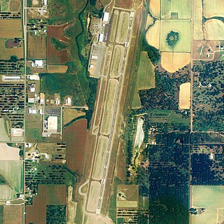
Mobile International Airport is a public use airport located three nautical miles (6 km) south of the central business district of Mobile, a city in Mobile County, Alabama, United States. The airport is a principal component of the Mobile Aeroplex at Brookley, a 1,650-acre (668 ha) industrial complex. Presently the facility covers 1,616 acres of land. It is owned and operated by the Mobile Airport Authority. Prior to 1969, the airport was part of an active military installation known as Brookley Air Force Base.

Montgomery Regional Airport is a civil-military airport seven miles southwest of Montgomery, the capital of Alabama. Owned by the Montgomery Airport Authority, it is used for general aviation and military aviation, and sees two airlines.

St. Clair County Airport is a public use airport located three nautical miles southeast of the central business district of Pell City, in St. Clair County, Alabama, United States. It is owned by the St. Clair County Airport Authority. According to the FAA's National Plan of Integrated Airport Systems for 2009–2013, it is categorized as a reliever airport for the Birmingham-Shuttlesworth International Airport.

Monroe County Airport is a county-owned public-use airport located three nautical miles (6 km) south of the central business district of Monroeville, in Monroe County, Alabama, United States. According to the FAA's National Plan of Integrated Airport Systems for 2009–2013, it is categorized as a general aviation facility.
H. L. Sonny Callahan Airport is a public-use airport located three nautical miles southeast of the central business district of Fairhope, a city in Baldwin County, Alabama, United States. It is owned by the Fairhope Airport Authority.

Moton Field Municipal Airport is a public-use airport located three nautical miles north of the central business district of Tuskegee, a city in Macon County, Alabama, United States. The airport is owned by the City of Tuskegee. It is included in the FAA's National Plan of Integrated Airport Systems for 2011–2015, which categorized it as a general aviation facility.

Roanoke Municipal Airport is two miles south of Roanoke, in Randolph County, Alabama. The FAA's National Plan of Integrated Airport Systems for 2009–2013 categorized it as a general aviation facility.

Wetumpka Municipal Airport is a city-owned, public-use airport located six nautical miles west of the central business district of Wetumpka, a city in Elmore County, Alabama, United States. It is included in the FAA's National Plan of Integrated Airport Systems for 2011–2015, which categorized it as a general aviation facility. During World War II the airport, known then as Elmore Auxiliary Field, served as an auxiliary field for Gunter Army Airfield training operations. In 2013 the airport was listed in the Alabama Register of Landmarks and Heritage.
St. Elmo Airport is a public-use airport located two nautical miles west of the central business district of St. Elmo, in Mobile County, Alabama, United States. It is included in the FAA's National Plan of Integrated Airport Systems for 2011–2015, which categorized it as a general aviation facility.
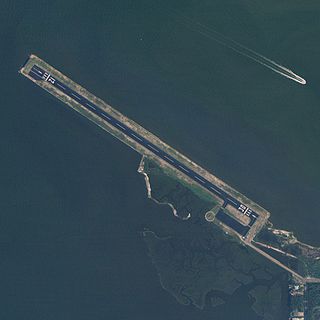
Jeremiah Denton Airport, formerly Dauphin Island Airport, is a county-owned public-use airport in Mobile County, Alabama, United States. It is just northwest of the central business district of Dauphin Island, a town located on a barrier island. The airport is on Mobile Bay, west of the Aloe Bay Channel.

Isbell Field is a city-owned public-use airport located two nautical miles north of the central business district of Fort Payne, a city in DeKalb County, Alabama, United States. According to the FAA's National Plan of Integrated Airport Systems for 2009–2013, it is categorized as a general aviation facility.

Geneva Municipal Airport is a city-owned public-use airport located two nautical miles north of the central business district of Geneva, a city in Geneva County, Alabama, United States. According to the FAA's National Plan of Integrated Airport Systems for 2009–2013, it is categorized as a general aviation facility.

Hartselle–Morgan County Regional Airport is a public-use airport located two nautical miles south of the central business district of Hartselle, a city in Morgan County, Alabama, United States. The airport was formerly known as Rountree Field, named in the 1960s for Asa Rountree Sr., a former head of the Alabama Department of Aeronautics.
Robbins Field is a public use airport located five nautical miles northeast of the central business district of Oneonta, a city in Blount County, Alabama, United States. It is owned by the City of Oneonta and Blount County. According to the FAA's National Plan of Integrated Airport Systems for 2009–2013, it is categorized as a general aviation facility.

North Pickens Airport is a county-owned public-use airport in Pickens County, Alabama, United States. It is located one nautical mile north of the central business district of Reform, Alabama. The airport is included in the FAA's National Plan of Integrated Airport Systems for 2011–2015, which categorized it as a general aviation facility.

Roy E. Ray Airport is a privately owned, public-use airport located three nautical miles northeast of the central business district of Bayou La Batre, a city in Mobile County, Alabama, United States.
McMinn Airport is a privately owned public-use airport located one nautical mile southwest of the central business district of Weaver, a city in Calhoun County, Alabama, United States.
Double Springs–Winston County Airport is a public-use airport located four nautical miles east of Double Springs, a town in Winston County, Alabama, United States.
Lamar County Airport is a public-use airport in Lamar County, Alabama, United States. It is owned by the Lamar County Commission and located six nautical miles north of the central business district of Vernon, Alabama.