
The Potomac River is found within the Mid-Atlantic region of the United States and flows from the Potomac Highlands into the Chesapeake Bay. The river is approximately 405 miles (652 km) long, with a drainage area of about 14,700 square miles (38,000 km2). In terms of area, this makes the Potomac River the fourth largest river along the East Coast of the United States and the 21st largest in the United States. Over 5 million people live within the Potomac watershed.

The Rouge River is a river in Markham, Pickering, Richmond Hill and Toronto in the Greater Toronto Area of Ontario, Canada. The river flows from the Oak Ridges Moraine to Lake Ontario at the eastern border of Toronto, and is the location of Rouge Park, the only national park in Canada within a municipality. At its southern end, the Rouge River is the boundary between Toronto and southwestern Pickering in the Regional Municipality of Durham.

The Huron River is a 130-mile-long (210 km) river in southeastern Michigan, rising out of the Huron Swamp in Springfield Township in northern Oakland County and flowing into Lake Erie, as it forms the boundary between present-day Wayne and Monroe counties. Thirteen parks, game areas, and recreation areas are associated with the river, which passes through the cities of Dexter, Ann Arbor, Ypsilanti, Belleville, Flat Rock and Rockwood that were developed along its banks.
Taddle Creek is a buried stream in Toronto, Ontario, Canada that flowed a southeasterly course about six kilometres long, from St. Clair Avenue west of Bathurst Street through the present site of Wychwood Park, through the University of Toronto, into the Toronto Harbour near the Distillery District. During the 19th century, it was buried and converted into an underground sewer, but traces of the creek can still be found today. The scenic footpath known as Philosopher's Walk follows the ravine created by the creek from the Royal Ontario Museum to Trinity College. Taddle Creek is also the name of a Toronto literary magazine and of a local Montessori school.

Taylor-Massey Creek is a tributary of the Don River in Toronto, Ontario. It flows through Scarborough and East York, where it enters the Don River. Taylor-Massey Creek has also been called Silver Creek and Scarboro Creek.
Coyote Creek is a river that flows through the Santa Clara Valley in Northern California. Its source is on Mount Sizer, in the mountains east of Morgan Hill. It eventually flows into Anderson Lake in Morgan Hill and then northwards through Coyote Valley to San Jose, where it empties into San Francisco Bay.
Wychwood Park is a neighbourhood enclave and private community in Toronto, Ontario, Canada. It is located west of Bathurst Street on the north side of Davenport Road, within the larger area of Bracondale Hill. It is considered part of the overall Wychwood official neighbourhood as designated by the City of Toronto.

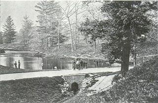
Trinity Square is a public square in downtown Toronto, Ontario, Canada. It is bounded by the Toronto Eaton Centre, an office building known as Bell Trinity Square, and the Marriott Downtown Eaton Centre Hotel. The square's primary feature is the Anglican Church of the Holy Trinity. The Henry Scadding House and Holy Trinity Rectory are heritage buildings that are also located in the square. It includes a fountain and ornamental pond, and a labyrinth path.

San Diego Creek is a 16-mile (26 km) urban waterway flowing into Upper Newport Bay in Orange County, California in the United States. Its watershed covers 112.2 square miles (291 km2) in parts of eight cities, including Irvine, Tustin, and Costa Mesa. From its headwaters in Laguna Woods the creek flows northwest to its confluence with Peters Canyon Wash, where it turns abruptly southwest towards the bay. Most of the creek has been converted to a concrete flood control channel, but it also provides important aquatic and riparian habitat along its course and its tidal estuary.
Medway Creek is a tributary of the Thames River in southwestern Ontario, Canada, draining into the North branch of the Thames at the University of Western Ontario.

The Cadoxton River is a short river in the Vale of Glamorgan, South Wales and with a length of about 5 miles/8 kilometres it is one of Wales's shortest rivers.

The Sheldrake River is a freshwater stream located in Southern Westchester County, New York. The river forms in White Plains and flows six miles (9.7 km) south until it joins the Mamaroneck River. Approximately 1.58 miles (2.54 km) of the Sheldrake River flow through Scarsdale, 2.13 miles (3.43 km) through New Rochelle and two miles (3.2 km) through the Town of Mamaroneck.

Ashbridge's Creek was a watercourse that flowed in Ashbridge's Bay, between the Don River and Highland Creek. Its headwaters were north of Greenwood and Danforth avenues, making it about 4 kilometres (2.5 mi) long.
Small's Creek was one of the three watercourses that flowed into Small's Pond, a small body of water of several acres in area, located near the intersection of Queen Street and Kingston Road, in Toronto, Ontario. There is a small plain between the shore of Lake Ontario and the bluffs which marked the shore of the larger Glacial Lake Iroquois, Bedrock was shallow on the plain. Smalls Creek, Tomlin's Creek, the other watercourse that drains into Smalls Pond, and Ashbridge's Creek to the east were all small, short watercourses, with their headwaters on that small plain, had each become polluted by the turn of the 20th century, when the regions they flowed through were annexed into the growing city of Toronto.

Smalls Pond was a pond located near Queen Street East and Kingston Road in Toronto, Canada. Some accounts say it was twelve feet deep, others that it was twelve meters deep. While some accounts say it was a natural feature, Jane Fairburn, in "Along the Shore: Rediscovering Toronto's Waterfront Heritage", wrote that gentleman farmer Charles Coxwell Small, owner of 472 acres, dammed a creek than called Serpentine Creek, to form the dam, for the water-power for sawmills.

Tomlin's Creek is short creek in Toronto, which drained into Small's Pond. Its headwaters seem to have been in the ravine that contains Glen Davis Crescent, because residents report small springs breaking out.

Tibbetts Brook, originally Tippett's Brook or Tibbitt's Brook, is a stream in the southern portion of mainland New York, flowing north to south from the city of Yonkers in Westchester County into the borough of the Bronx within New York City. Originally emptying into Spuyten Duyvil Creek as part of the Harlem River system, the stream is now partially subterranean, ending above ground at the south end of Van Cortlandt Lake within Van Cortlandt Park. There it proceeds into city sewers, draining into either the northern end of the Harlem River or the Wards Island Water Pollution Control Plant. The brook provides significant watershed to both Van Cortlandt Park at its south end and Tibbetts Brook Park at its north end. There have been modern proposals to daylight the southern portion of the brook back onto the surface.

The Toronto waterway system comprises a series of natural and man-made watercourses in the Canadian city of Toronto. The city is dominated by a large river system spanning most of the city including the Don River, Etobicoke Creek, Highland Creek, Humber River, Mimico Creek and Rouge River.
Wendigo Creek was a short watercourse in Toronto, Ontario, that drained into Grenadier Pond. It was spring fed, like nearby Spring Creek. Its headwaters were north of Bloor Street, near Dundas Street and Laws Street.

Rattlesnake Creek is an underground waterway in the northeast Bronx, New York City. It flowed above ground level until the mid-20th century, with a waterfall and a pond over its course. Rattlesnake Creek has since been mostly covered over, but a small portion of it is still visible in Seton Falls Park.
