
The Missouri River is the longest river in the United States. Rising in the Rocky Mountains of the Eastern Centennial Mountains of Southwestern Montana, the Missouri flows east and south for 2,341 miles (3,767 km) before entering the Mississippi River north of St. Louis, Missouri. The river drains a sparsely populated, semi-arid watershed of more than 500,000 square miles (1,300,000 km2), which includes parts of ten U.S. states and two Canadian provinces. Although nominally considered a tributary of the Mississippi, the Missouri River above the confluence is much longer than the Mississippi above the confluence and carries a comparable volume of water. When combined with the lower Mississippi River, it forms the world's fourth longest river system.

The Crow, whose autonym is Apsáalooke, also spelled Absaroka, are Native Americans living primarily in southern Montana. Today, the Crow people have a federally recognized tribe, the Crow Tribe of Montana, with an Indian reservation located in the south-central part of the state.

Williams County is located on the western border of the U.S. state of North Dakota, next to Montana. As of the 2020 census, the population was 40,950. Its county seat is Williston.

Williston is a city in and the county seat of Williams County, North Dakota, United States. The 2020 census gave its population as 29,160, making Williston the sixth-largest city in North Dakota. The city's population nearly doubled between 2010 and 2020, due largely to the North Dakota oil boom.

The Dakotas is a collective term for the U.S. states of North Dakota and South Dakota. It has been used historically to describe the Dakota Territory, and is still used for the collective heritage, culture, geography, fauna, sociology, economy, and cuisine among the two states.

Garrison Dam is an earth-fill embankment dam on the Missouri River in central North Dakota, U.S. Constructed by the U.S. Army Corps of Engineers from 1947 to 1953, at over 2 miles (3.2 km) in length, the dam is the fifth-largest earthen dam in the world. The reservoir impounded by the dam is Lake Sakakawea, which extends to Williston and the confluence with the Yellowstone River, near the Montana border.

The Yellowstone River is a tributary of the Missouri River, approximately 692 miles (1,114 km) long, in the Western United States. Considered the principal tributary of upper Missouri, via its tributaries, it drains an area with headwaters across the mountains and high plains of southern Montana and northern Wyoming, and stretching east from the Rocky Mountains in the vicinity of Yellowstone National Park. It flows northeast to its confluence with the Missouri River on the North Dakota side of the border, about 25 miles west of present-day Williston.

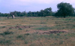
Fort Union Trading Post National Historic Site is a partial reconstruction of the most important fur trading post on the upper Missouri, 1829-1867. The fort site is about two miles from the confluence of the Missouri River and its tributary, the Yellowstone River, on the Dakota side of the North Dakota/Montana border, 25 miles from Williston, North Dakota.

The Geography of North Dakota consists of three major geographic regions: in the east is the Red River Valley, west of this, the Missouri Plateau. The southwestern part of North Dakota is covered by the Great Plains, accentuated by the Badlands. There is also much in the way of geology and hydrology.

The North Dakota Lewis and Clark Interpretive Center, operated by the North Dakota Parks and Recreation Department, interprets the history of the Lewis and Clark Expedition. It focuses on the winter of 1804–1805, which they spent at Fort Mandan, a post they built near a Mandan village. The center was opened in 1997 and overlooks the Missouri River on the outskirts of Washburn, North Dakota, the center opened in 1997. It is located about two miles from the reconstructed Fort Mandan.

Fort Buford was a United States Army Post at the confluence of the Missouri and Yellowstone rivers in Dakota Territory, present day North Dakota, and the site of Sitting Bull's surrender in 1881.
Buford is an unincorporated community in Williams County, North Dakota, United States. It is the nearest community to the Fort Union Trading Post National Historic Site. It is named for the nearby historic Fort Buford at the confluence of the Missouri and Yellowstone Rivers.

The Williston Basin is a large intracratonic sedimentary basin in eastern Montana, western North Dakota, South Dakota, and southern Saskatchewan, that is known for its rich deposits of petroleum and potash. The basin is a geologic structural basin but not a topographic depression; it is transected by the Missouri River. The oval-shaped depression extends approximately 475 miles (764 km) north-south and 300 miles (480 km) east-west.
Fort Pierre Chouteau, also just Fort Pierre, was a major trading post and military outpost in the mid-19th century on the west bank of the Missouri River in what is now central South Dakota. Established in 1832 by Pierre Chouteau, Jr. of St. Louis, Missouri, whose family were major fur traders, this facility operated through the 1850s.
Fort Henry on the Missouri River, located at the mouth of the Yellowstone where it enters the Missouri, was established on October 1, 1822 by a party of men led by Major Andrew Henry, who mounted the expedition for the purpose of establishing a fur trade outpost for an area which now encompasses most of Montana, western North Dakota, parts of Wyoming, into Canada. The site of the fort, which was abandoned in 1823, is approximately 20 miles (32 km) southwest of Williston, North Dakota near the Montana - North Dakota state line.
The Battle of the Badlands was fought in Dakota Territory, in what is now western North Dakota, between the United States army led by General Alfred Sully and the Lakota, Yanktonai, and the Dakota Indian tribes. The battle was fought August 7–9, 1864 between what are now Medora and Sentinel Butte, North Dakota. It was an extension of the conflict begun in the Dakota War of 1862. Sully successfully marched through the badlands encountering only moderate resistance from the Sioux.

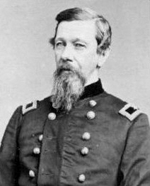
Grant Prince Marsh was a riverboat pilot and captain who was noted for his many piloting exploits on the upper Missouri River and the Yellowstone River in Montana from 1862 until 1882. He started to work as a cabin boy in 1856, eventually becoming a captain, riverboat pilot and riverboat owner, in a career lasting over sixty years. During that time, he achieved an outstanding record and reputation as a river steamboat pilot and captain, serving on more than 22 vessels. His piloting exploits became legendary and modern historians refer to him as "Possibly the greatest steamboat man ever", "possibly the greatest [steamboat pilot] ever", "possibly the finest riverboat pilot who ever lived", "the greatest steamboat master and pilot on both the Missouri and Yellowstone Rivers"

The fur trade in Montana was a major period in the area's economic history from about 1800 to the 1850s. It also represents the initial meeting of cultures between indigenous peoples and those of European ancestry. British and Canadian traders approached the area from the north and northeast focusing on trading with the indigenous people, who often did the trapping of beavers and other animals themselves. American traders moved gradually up the Missouri River seeking to beat British and Canadian traders to the profitable Upper Missouri River region.

Crow Flies High was the chief of a band of dissident Hidatsa people from 1870 until their band joined the reservation system in 1894. This band was one of the last to settle on an Indian reservation. A North Dakota State Park is named after him.
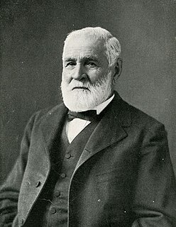
Joseph Marie LaBarge was an American steamboat captain, most notably of the steamboats Yellowstone, and Emilie, that saw service on the Mississippi and Missouri rivers, bringing fur traders, miners, goods and supplies up and down these rivers to their destinations. During much of his career LaBarge was in the employ of the American Fur Company, a giant in the fur trading business, before building his own steamboat, the Emilie, to become an independent riverman. During his career he exceeded several existing speed and distance records for steamboats on the Missouri River. Passengers aboard his vessels sometimes included notable people, including Abraham Lincoln. LaBarge routinely offered his steamboat services gratis to Jesuit missionaries throughout his career.
