
Scouting in South Dakota has a long history, from the 1910s to the present, and serves thousands of youth in programs that suit the environment in which they live.
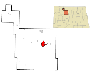
Minot is a city in and the county seat of Ward County, North Dakota, United States, in the state's north-central region. It is most widely known for the Air Force base approximately 15 miles (24 km) north of the city. With a population of 48,377 at the 2020 census. Minot is the state's fourth-largest city and a trading center for a large part of northern North Dakota, southwestern Manitoba, and southeastern Saskatchewan. Founded in 1886 during the construction of James J. Hill's Great Northern Railway, Minot is also known as "Magic City", commemorating its remarkable growth in size over a short time.
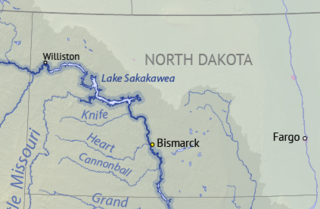
Lake Sakakawea is a large reservoir in the north central United States, impounded in 1953 by Garrison Dam, a U.S. Army Corps of Engineers dam located in the Missouri River basin in central North Dakota. Named for the Shoshone-Hidatsa woman Sakakawea, it is the largest man-made lake located entirely within the State of North Dakota, the second largest in the United States by area after Lake Oahe, and the third largest in the United States by volume, after Lake Mead and Lake Powell.

Garrison Dam is an earth-fill embankment dam on the Missouri River in central North Dakota, U.S. Constructed by the U.S. Army Corps of Engineers from 1947 to 1953, at over 2 miles (3.2 km) in length, the dam is the fifth-largest earthen dam in the world. The reservoir impounded by the dam is Lake Sakakawea, which extends to Williston and the confluence with the Yellowstone River, near the Montana border.

The International Joint Commission is a bi-national organization established by the governments of the United States and Canada under the Boundary Waters Treaty of 1909. Its responsibilities were expanded with the signing of the Great Lakes Water Quality Agreement of 1972. The commission deals with issues affecting the extensive waters and waterways along the Canada–United States border.

The Souris River or Mouse River is a river in central North America. It is about 700 km (430 mi) in length and drains about 23,600 square miles (61,100 km2). It rises in the Yellow Grass Marshes north of Weyburn, Saskatchewan. It wanders south through North Dakota beyond Minot to its most southern point at the city of Velva, and then back north into Manitoba. The river passes through the communities of Melita, Hartney, Souris and Wawanesa and on to its confluence with the Assiniboine River near Treesbank, about 25 miles (40 km) southeast of Brandon. The main tributaries which flow into the Souris in Manitoba are the Antler River, the Gainsborough and Plum Creeks. Much of its drainage basin is fertile silt and clay deposited by former glacial Lake Souris.
Devils Lake is a lake in the U.S. state of North Dakota. It is the largest natural body of water and the second-largest body of water in North Dakota after Lake Sakakawea. It can reach a level of 1,458 ft (444 m) before naturally flowing into the Sheyenne River via the Tolna Coulee. On June 27, 2011, it reached an unofficial historical high elevation of 1,454.3 ft (443.3 m). The cities of Devil's Lake and Minnewaukan take their name from the lake as does the Spirit Lake Reservation, which is located on the lake's southern shores.

The Pick–Sloan Missouri Basin Program, formerly called the Missouri River Basin Project, was initially authorized by the Flood Control Act of 1944, which approved the plan for the conservation, control, and use of water resources in the Missouri River Basin.
The Minot Area Growth through Investment and Cooperation Fund, or MAGIC Fund, is a growth fund financed through a one percent sales tax in the city of Minot, North Dakota. The fund was approved by voters on May 1, 1990, and the money is used for economic development, capital improvements and property tax relief. As of 2012 the MAGIC Fund has invested over $33 million into 200 projects in 44 communities.

The Grant Devine Dam, formally Alameda Dam, is an embankment dam located near Alameda, and Oxbow, Saskatchewan, Canada. It was constructed in 1994 to control flows on the Moose Mountain Creek, and Souris River. It provides flood protection and irrigation for this area of Saskatchewan, along with protection for Minot, North Dakota. The Grant Devine Reservoir provides opportunities for recreational use such as boating and fishing. At the full supply level of 562 metres (1,844 ft), the reservoir holds 105,000,000 cubic metres (3.7×10⁹ cu ft) of water. The project is owned and operated by the Saskatchewan Water Security Agency (formerly Saskatchewan Watershed Authority).

Highway 39 is a provincial, paved, undivided highway located in the southern portion of the Canadian province of Saskatchewan connecting North Portal and Moose Jaw in the north. This is a primary Saskatchewan highway maintained by the provincial and national governments and providing a major trucking and tourism route between the United States via Portal, Burke County, North Dakota, and North Portal, Saskatchewan. On July 3, 2000, Highways and Transportation Minister Maynard Sonntag officiated at the ribbon cutting ceremony opening the new duty-free shop and the twinned highway at Saskatchewan's busiest border crossing. Highway 39 is one of Canada's busiest highways, facilitating transport for $6 billion in trade goods via approximately 100,000 trucks over the year. The entire length of highway 39 is paved. The CanAm Highway comprises Saskatchewan Highways Hwy 35, Hwy 39, Hwy 6, Hwy 3, as well as Hwy 2. 44.3 miles (71.3 km) of Saskatchewan Highway 39 contribute to the CanAm Highway between Weyburn and Corinne. Highway 39 is divided or twinned in two areas at North Portal as well as north of Weyburn for 1.7 kilometres (1.1 mi). The junction of Hwy 39 with the Trans–Canada divided four-lane highway is done via a "Parclo" or partial cloverleaf interchange.
The geography of Minot, North Dakota is treated extensively in this article.
The Central Utah Project is a US federal water project that was authorized for construction under the Colorado River Storage Project Act of April 11, 1956, as a participating project. In general, the Central Utah Project develops a portion of Utah's share of the yield of the Colorado River, as set out in the Colorado River Compact of 1922.
The Water Resources Development Act of 1986 is part of Pub.L. 99–662, a series of acts enacted by Congress of the United States on November 17, 1986.
The Water Resources Development Act of 2000, Pub.L. 106–541 (text)(PDF), was enacted by Congress of the United States on December 11, 2000. Most of the provisions of WRDA 2000 are administered by the United States Army Corps of Engineers.
Upper Souris National Wildlife Refuge, located 30 miles (48 km) northwest of Minot, North Dakota, was established in 1935 as a refuge and breeding ground for migratory birds and other wildlife. The refuge straddles 35 miles (56 km) of the picturesque Souris River valley in northern North Dakota. The Souris River basin figures prominently in the cultural and natural history of the North American mid-continent plains and prairies.
SRT Communications is the largest telecommunications cooperative in North Dakota, serving over 50,000 people with Internet, Security Alarm and Video Surveillance, TV and Business Phone Systems and services.

The 2011 Souris/Mouse River flood in Canada and the United States occurred in June and was greater than a hundred-year flooding event for the river. The US Army Corps of Engineers estimated the flood to have a recurrence interval of two to five centuries.

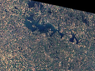
Lake Darling Dam is an earthen embankment dam on the Souris River located 20 mi (32 km) northwest of Minot, in Ward County, North Dakota. The dam began impounding water in April 1936 and was completed July of that year. It was created for the purposes of water storage and conservation. It is part of the Upper Souris National Wildlife Refuge and is owned by the United States Fish and Wildlife Service. The dam and lake are named after Jay N. "Ding" Darling, the first director of the Bureau of Biological Survey. Although the dam is located in Ward County, Lake Darling is almost entirely located in Renville County, to its north.

Downtown Minot is the central business district of Minot, North Dakota, located south of the Souris River in the Souris Valley. Downtown is the site of the first permanent settlement in Minot in 1886. Downtown is home to many of Minot's cultural sites of interest. It is also home to numerous galleries, stores and restaurants. The Minot Riverwalk traverses the downtown.