
Yoho National Park is a national park of Canada. It is located within the Rocky Mountains along the western slope of the Continental Divide of the Americas in southeastern British Columbia, bordered by Kootenay National Park to the south and Banff National Park to the east in Alberta. The word Yoho is a Cree expression of amazement or awe, and it is an apt description for the park's spectacular landscape of massive ice fields and mountain peaks, which rank among the highest in the Canadian Rockies.

Kootenay National Park is a national park of Canada in southeastern British Columbia. The park consists of 1,406 km2 (543 sq mi) of the Canadian Rockies, including parts of the Kootenay and Park mountain ranges, the Kootenay River and the entirety of the Vermilion River. While the Vermilion River is completely contained within the park, the Kootenay River has its headwaters just outside the park boundary, flowing through the park into the Rocky Mountain Trench and eventually joining the Columbia River. The park ranges in elevation from 918 m (3,012 ft) at the southwestern park entrance to 3,424 m (11,234 ft) at Deltaform Mountain.
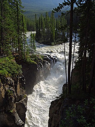
Sunwapta Falls is a pair of waterfalls of the Sunwapta River in Jasper National Park, Alberta, Canada.

The Bridal Veil Falls is a waterfall located on Bridal Veil Creek along the Columbia River Gorge in Multnomah County, Oregon, United States. The waterfall is accessible from the historic Columbia River Highway and Interstate 84. Spanning two tiers on basalt cliffs, it is the only waterfall which occurs below the historic Columbia Gorge Scenic Highway. The Bridal Veil Falls Bridge, built in 1914, crosses over the falls, and is listed on the National Register of Historic Places.

Little Qualicum Falls Provincial Park is a provincial park in British Columbia, Canada, on central Vancouver Island, that encompasses the entire southern shore of Cameron Lake. The Island Rail Corridor line to Port Alberni passes through the park.

Nairn Falls Provincial Park is a provincial park in British Columbia, Canada located on the Green River adjacent to British Columbia Highway 99 and the Canadian National Railway line just south of Pemberton and less than twenty minutes north of the resort town of Whistler. The 170 hectare park was established in 1966, shortly after the highway's opening, to protect and enhance visitor access to Nairn Falls.

Divide Creek is a short creek near Kicking Horse Pass on the British Columbia/Alberta border. After following the Continental Divide of the Americas for a short distance, the creek forks, with one side draining through the Bow River east to Hudson Bay and the Arctic Ocean, and the other side draining west to the Pacific Ocean by way of the Kicking Horse River.

The Waputik Icefield is located on the Continental divide in the Canadian Rocky Mountains, in the provinces of British Columbia and Alberta. It is developed on the heights of the Waputik Range in the Central Main Ranges.

Saskatchewan River Crossing is a locality in western Alberta, Canada. It is located within Banff National Park at the junction of Highway 93 and Highway 11. It is administered by Improvement District No. 9.
Alberta's Rockies comprise the Canadian Rocky Mountains in Alberta, Canada. On the southwestern part of the province along the British Columbia border, the region covers all but the south of Census Division 15.

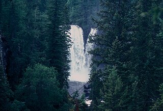
Siffleur Falls are a series of three separate waterfalls on the Siffleur River, an early tributary of the North Saskatchewan River. The falls are a short distance from the David Thompson Highway, in the Siffleur Wilderness Area, just north of Banff National Park.

Canim Falls is a 23 metre high waterfall on the Canim River between Canim Lake and Mahood Lake in Wells Gray Provincial Park in the Cariboo region of the Central Interior of British Columbia, Canada. The waterfall has eroded steadily upstream and created a 4 km (2.5 mi) long canyon cut into a lava plateau associated with the Wells Gray-Clearwater volcanic field.
Mahood Falls is a waterfall in Wells Gray Provincial Park located on the Canim River between Canim Lake and Mahood Lake and northeast of 100 Mile House, British Columbia, Canada. The waterfall is 20 m (66 ft) high.
Blaeberry Falls is a waterfall on the lower Blaeberry River in the Columbia Country area of the Canadian Rockies in British Columbia, Canada. It is more usually known locally as Thompson Falls, after the explorer David Thompson. It is located approximately 7 km from the river's confluence with the Columbia River at the locality of Blaeberry, British Columbia, just northwest of the town of Golden.
Simpson Pass, el. 2,107 m (6,913 ft), is a mountain pass on the border between the Canadian provinces of Alberta and British Columbia, in the area of the Ball Range. It is the prominence col for Mount Ball on the Continental Divide in the vicinity of Sunshine Village ski resort. Simpson River and Simpson Pass are named after Sir George Simpson who first explored the area in 1841.

Angel's Staircase Falls is a tall cascade on an unnamed tributary of the Yoho River in British Columbia's Yoho National Park. It drops approximately 1000 feet down to its confluence with the river. A short spur off the Yoho Valley Trail leads to a viewpoint of the views situated at the banks of the Yoho River. The view is distant, and the entire falls can not be seen because of the twisting nature of the falls themselves.

The Twin Falls Tea House National Historic Site of Canada, located in Yoho National Park, British Columbia as a resting place for hikers and trail riders in the park. The rustic structure is located near Twin Falls in the Little Yoho Valley. The first phase of construction took place about 1908. A separate two-story cabin was built adjoining the original cabin about 1923, and the two structures were linked between 1925 and 1928. Proposed for demolition in 1969, the Tea House was designated a National Historic Site of Canada in 1992, and was extensively renovated in 2005.

Cascade Falls Regional Park is a regional park under the administration of the Fraser Valley Regional District in the Hatzic Valley of the Lower Mainland region of British Columbia, Canada. The park was originally 9.5 hectares in area but was expanded to a current 22 hectares. It has picnic tables and pit toilets, with various hiking trails and a walkway leading to a viewing platform over a large waterfall, which is 15 minutes walk from the park's parking lot.

Twin Falls is a waterfall in British Columbia, Canada. It is 590 feet high. It is found in Yoho National Park.
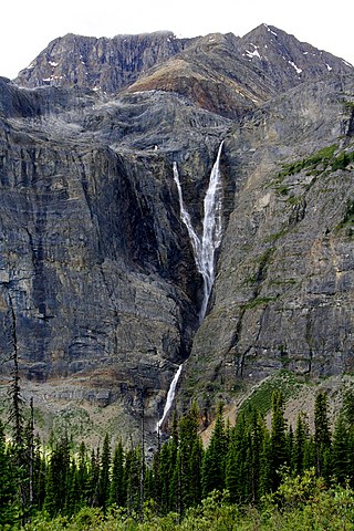
Helmet Falls is a tiered waterfall located in Kootenay National Park in British Columbia, Canada. With total height of 352 metres (1,155 ft), Helmet Falls is the 11th tallest confirmed waterfall in the Canadian Rockies, as well as one of the most significant waterfalls in British Columbia based on both height and volume.
