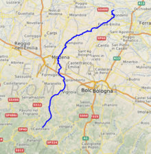
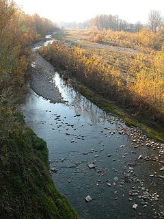
The Panaro is an Italian river and the final right-hand tributary to the Po, discounting the Cavo Napoleonicocanal. It runs right across Emilia-Romagna in a north-easterly direction: from its source close to the Apenninewatershed, where Emilia-Romagna meets Tuscany, to its outlet where the Po marks the region's boundary with Veneto. Its Latin name was Scultenna.
It is 148 kilometres (92mi) long, with a 2,292-square-kilometre (885sqmi)drainage basin; alternating between aridity in summer and fullness in spring and autumn.
Its principal source, the Rio delle Tagliole, rises at Foce a Giovo, Monte Rondinaio, some 12 kilometres (7mi) south-west of highest peak of the Tuscan-EmillianApennines, Monte Cimone, elevation 2,165 metres (7,103ft). From here it flows down the valley in a northeastern direction. At Pievepelago (in the Province of Modena) it changes name to Scoltenna, assuming in the territory of Pavullo nel Frignano finally that of Panaro. In this area it makes up the border between the communities of Montana del Frignano and Montana dell’appennino Modena Est. Close to Modena, it joins the Naviglio de Modena and becomes navigable until its confluence with the Po, a little to the west of Ferrara. It runs through Vignola, Finale Emilia and Bondeno.
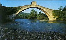
Of particular historical and artistic interest is the bridge of Olina, constructed in 1522, crossing the river close to the small town of the same name, in the commune of Pavullo nel Frignano
This article related to a river in Italy is a stub. You can help Wikipedia by expanding it.
Emilia-Romagna is one of the 20 administrative regions of Italy, situated in the northeast section of the country, comprising the historical regions of Emilia and Romagna. Its capital is Bologna. It has an area of 22,446 km2 (8,666 sq mi), and about 4.4 million inhabitants.
The Apennines or Apennine Mountains are a mountain range consisting of parallel smaller chains extending c. 1,200 km (750 mi) along the length of peninsular Italy. In the northwest they join with the Ligurian Alps at Altare. In the southwest they end at Reggio di Calabria, the coastal city at the tip of the peninsula. Since 2000 the Environment Ministry of Italy, following the recommendations of the Apennines Park of Europe Project, has been defining the Apennines System to include the mountains of north Sicily, for a total distance of 1,500 kilometres (930 mi). The system forms an arc enclosing the east side of the Ligurian and Tyrrhenian Seas.
The Trebbia is a river predominantly of Liguria and Emilia Romagna in northern Italy. It is one of the four main right-bank tributaries of the river Po, the other three being the Tanaro, the Secchia and the Panaro.
The province of Bologna was a province in the Emilia-Romagna region of Italy. Its provincial capital was the city of Bologna. The province of Bologna covered an area of 3,702.32 square kilometres (1,429.47 sq mi) and had a total population of 1,004,323 inhabitants as of 31 December 2014, giving it a population density of 271.27 inhabitants per square kilometre. It was replaced by the Metropolitan City of Bologna starting from January 2015.
The Secchia is an Italian river. One of the main right bank tributaries of the Po, it flows through the Emilia-Romagna region in northern Italy.
The Arda is a torrent of Emilia-Romagna, Italy, nearly all of its course being within the province of Piacenza. It is a right tributary of the Po River.
The Taro is a river in Emilia-Romagna, in northern Italy. It is a tributary of the Po and is 126 kilometres (78 mi) long. It flows almost entirely in the province of Parma, west of the city Parma. The Taro flows into the Po near Gramignazzo, a frazione of the comune of Sissa, north of Parma.
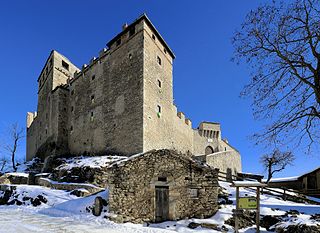
Pavullo nel Frignano is a town and comune in the province of Modena, Emilia-Romagna, Italy, in the Modenese Apeninnes. It is home to the medieval Castle of Montecuccolo, birthplace of the 17th century condottiero Raimondo Montecuccoli, and of the pieve of San Giovanni Battista di Renno. The town was extensively damaged during World War II due to its proximity to the Gothic Line.
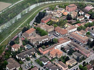
Camposanto is a comune (municipality) in the Province of Modena in the Italian region Emilia-Romagna, located about 35 kilometres (22 mi) northwest of Bologna and about 20 kilometres (12 mi) northeast of Modena on the Panaro river. Although the name in Italian literally means "saint's field", which normally means "cemetery" in Italian, its original (Latin) name, "Campus Sanctus", probably honoured the 14th century Ferrara family of Santi, who owned the land.
Guiglia is a comune (municipality) in the Province of Modena in the Italian region Emilia-Romagna, located about 30 kilometres (19 mi) southwest of Bologna and about 25 kilometres (16 mi) south of Modena.
Lama Mocogno is a comune (municipality) in the Province of Modena in the Italian region Emilia-Romagna, located about 50 kilometres (31 mi) southwest of Bologna and about 40 kilometres (25 mi) southwest of Modena. The Monte Cimone is located nearby.
Marano sul Panaro is a comune (municipality) in the Province of Modena in the Italian region Emilia-Romagna, located about 30 kilometres west of Bologna and about 20 kilometres south of Modena.
Montecreto is a comune (municipality) in the Province of Modena in the Italian region Emilia-Romagna, located about 60 kilometres (37 mi) southwest of Bologna and about 50 kilometres (31 mi) southwest of Modena.
Pievepelago is a comune (municipality) in the Province of Modena in the Italian region of Emilia-Romagna in the heart of the northern Apennine Mountains. Situated on the Scoltenna river, in a mountain valley, it is a tourist resort crossed by the "Via Vandelli".
Savignano sul Panaro is a comune (municipality) in the Province of Modena in the Italian region Emilia-Romagna, located about 25 kilometres (16 mi) west of Bologna and about 20 kilometres (12 mi) southeast of Modena.
Serramazzoni is a comune (municipality) in the Province of Modena in the Italian region Emilia-Romagna, located about 45 kilometres (28 mi) west of Bologna and about 30 kilometres (19 mi) southwest of Modena.
Sestola is a comune (municipality) in the Province of Modena in the Italian region Emilia-Romagna, located about 60 kilometres (37 mi) southwest of Bologna and about 50 kilometres (31 mi) southwest of Modena. It is located near the Monte Cimone and other mountains of the northern Apennines separating Emilia and Tuscany.
Zocca is a comune (municipality) in the Province of Modena in the Italian region Emilia-Romagna, located about 45 kilometres (28 mi) southwest of Bologna and about 35 kilometres (22 mi) south of Modena.
"G. Paolucci" Airport is an Italian airport located in 'I Piani' in Pavullo, about 2 km south of Pavullo nel Frignano, Italy. The airport is used for general aviation, business aviation, leisure and sport aviation activities, and for civil protection and rescue functions. Inside there is both a flight school for piloting gliders, and a motorized flight school for VDS equipment, basic and advanced, with the possibility of making preparatory flights to the teaching activity.
The Tidone is a river in the Region of Emilia Romagna in northern Italy. It is a right-bank tributary of the Po River. The stream rises in the Apennine Mountains near Monte Penice and flows in a northerly direction into the Po.
This page is based on this Wikipedia article Text is available under the CC BY-SA 4.0 license; additional terms may apply. Images, videos and audio are available under their respective licenses.