Phillimore Island

Last updated

Phillimore Island from the Shiplake bank PhillimoreIsland01.JPG
Phillimore Island from the Shiplake bank

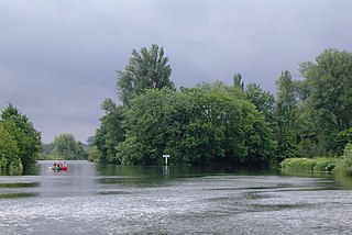
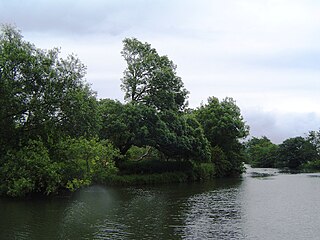
Phillimore Island is an elongated island in the River Thames in the county of Berkshire, England, near the villages of Shiplake, Oxfordshire and Wargrave, Berkshire. It is on the reach above Shiplake Lock. [1]

River Thames river in southern England

The River Thames, known alternatively in parts as the Isis, is a river that flows through southern England including London. At 215 miles (346 km), it is the longest river entirely in England and the second longest in the United Kingdom, after the River Severn.

Berkshire County of England

Berkshire is one of the home counties in England. It was recognised by the Queen as the Royal County of Berkshire in 1957 because of the presence of Windsor Castle, and letters patent were issued in 1974. Berkshire is a county of historic origin, a ceremonial county and a non-metropolitan county without a county council. The county town is Reading.

Shiplake village and civil parish in South Oxfordshire district, Oxfordshire, England

Shiplake is a village and civil parish beside the River Thames 2 miles (3 km) south of Henley-on-Thames, Oxfordshire, England. The river forms the parish boundary to the east and south, and also the county boundary between Oxfordshire and Berkshire.

Contents

The island is named after the Phillimore family who were formerly the owners of Shiplake House, now Shiplake College, on the Oxfordshire bank. [2]

Baron Phillimore

Baron Phillimore, of Shiplake in the County of Oxford, is a title in the Peerage of the United Kingdom. It was created in 1918 for the former Judge of the High Court of Justice and Lord Justice of Appeal, Sir Walter Phillimore, 2nd Baronet. The Phillimore Baronetcy, of The Coppice, had been created in the Baronetage of the United Kingdom on 28 December 1881 for his father Sir Robert Phillimore, who was also a noted lawyer and judge. The first Baron was succeeded by his son, the second Baron.

Shiplake College

Shiplake College is an independent boarding and day school in Shiplake, by the River Thames just outside Henley-on-Thames, England. The school, with 480 pupils, takes boys from 11–18 and girls from 16–18.

Phillimore Island is quite centrally located in the River Thames. [3]

See also

Related Research Articles

Oxfordshire County of England

Oxfordshire is a county in South East England. The ceremonial county borders Warwickshire to the north-west, Northamptonshire to the north-east, Buckinghamshire to the east, Berkshire to the south, Wiltshire to the south-west and Gloucestershire to the west.

Marsh Lock lock and weir situated on the River Thames in England near Henley-on-Thames

Marsh Lock is a lock and weir situated on the River Thames in England near Henley-on-Thames, Oxfordshire. The lock is close to the Berkshire bank, but accessed from the Oxfordshire side via two long walkways, the downstream one being near Mill Meadows. The first pound lock was built by the Thames Navigation Commission in 1773.

Shiplake Lock

Shiplake Lock is a lock and weir situated on the River Thames in England near the village of Shiplake, Oxfordshire. It is just above the points where the River Loddon joins the Thames and Shiplake Railway Bridge crosses the river. The first pound lock was built by the Thames Navigation Commission in 1773.

Sonning Bridge grade II listed deck arch bridge in the United kingdom

Sonning Bridge is a road bridge across the River Thames at Sonning, Berkshire. It links Sonning with Sonning Eye (Oxfordshire) and crosses the Thames on the reach above Shiplake Lock, just short of Sonning Lock. It is a brick arch bridge completed in 1775, to replace an earlier wooden bridge. The bridge has been the subject of many paintings and prints by artists and is a Grade II listed building.

Mill Meadows, Henley-on-Thames

Mill Meadows is part of the flood plain of the River Thames at Henley-on-Thames, Oxfordshire, England. It is an area of natural beauty close to the town centre of Henley. Marsh Lock and Rod Eyot are also close by and the River and Rowing Museum, established in 1998, is located there. There is car parking available for visitors.

Sonning Regatta is the regatta of the village of Sonning in Berkshire and the hamlet of Sonning Eye in Oxfordshire, England, on the north and south banks of the River Thames.

Eye and Dunsden civil parish in South Oxfordshire district, Oxfordshire, England

Eye and Dunsden is a largely rural civil parish in the most southern part of English county of Oxfordshire.

Shiplake Railway Bridge bridge in United Kingdom

Shiplake Railway Bridge carries the Henley Branch Line to Henley-on-Thames, England across the River Thames, connecting Shiplake in Oxfordshire with Wargrave in Berkshire. It crosses the river just downstream of Shiplake Lock on the reach above Marsh Lock.

Buck Ait island in the River Thames

Buck Ait is an island in the River Thames in Oxfordshire, England. It is on the reach above Shiplake Lock near Sonning.

The Lynch island in the River Thames

The Lynch is an island in the River Thames in Berkshire, England. It is on the reach above Shiplake Lock near Lower Shiplake.

Hallsmead Ait island in the River Thames

Hallsmead Ait is an island in the River Thames in Berkshire, England. It is on the reach above Shiplake Lock near Lower Shiplake.

Handbuck Eyot island in the River Thames

Handbuck Eyot or Handbuck Ait is a thin, wooded island in the River Thames in England towards the eastern edge of the villages of Shiplake, Oxfordshire. It is on the reach above Marsh Lock.

Ferry Eyot island in the River Thames

Ferry Eyot or Ferry Ait is an island in the River Thames in England near the villages of Shiplake, Oxfordshire and Wargrave, Berkshire. It is on the reach above Marsh Lock.

St Patricks Stream river in the United Kingdom

St Patrick's Stream or Patrick Stream is a backwater of the River Thames in England, which flows into the River Loddon near Wargrave, Berkshire. It leaves the Thames on the reach above Shiplake Lock near Buck Ait, downstream of Sonning.

Poplar Eyot or Poplar Ait is an island in the River Thames in England near the villages of Shiplake, Oxfordshire and Wargrave, Berkshire. It is on the reach above Marsh Lock.

Shiplake Court was a historic manor house near Henley-on-Thames in Oxfordshire, England. In the sixteenth century, it was the residence of Edmund Plowden. In 1897, it had its own electricity generating plant, managed by Stuart Turner. The independent school, Shiplake College, is now on the manor house's grounds.

Hennerton Backwater is a narrow backwater of the River Thames on the reach above Marsh Lock near the villages of Shiplake, Oxfordshire and Wargrave, Berkshire.

Sonning Hill hill near the village of Sonning in Berkshire, England

Sonning Hill is a hill near the village of Sonning in Berkshire, England, close to the River Thames.

Berry Brook

The Berry Brook is a stream close to Sonning Eye in the flood plain of the River Thames, in southern Oxfordshire, England.

References

  1. Cove-Smith, Chris (1996). The River Thames Book. St Ives, Cambridgeshire: Imray Laurai Norie & Wilson. p. 92 (Map 14). ISBN   0-85288-286-6.
  2. Fred. S. Thacker, Fred S. (1920). The Thames Highway: Volume II Locks and Weirs. Republished 1968, David & Charles.
  3. Reading, Henley-on-Thames, Wokingham: Street AZ Atlas. Geographer' A-Z Map Company. 1995. p. 15. ISBN   0-85039-277-2.
Next island upstream River Thames Next island downstream
The Lynch Phillimore Island Unnamed Eyot

Coordinates: 51°29′53″N0°53′25″W / 51.49806°N 0.89028°W / 51.49806; -0.89028

Geographic coordinate system Coordinate system

A geographic coordinate system is a coordinate system that enables every location on Earth to be specified by a set of numbers, letters or symbols. The coordinates are often chosen such that one of the numbers represents a vertical position and two or three of the numbers represent a horizontal position; alternatively, a geographic position may be expressed in a combined three-dimensional Cartesian vector. A common choice of coordinates is latitude, longitude and elevation. To specify a location on a plane requires a map projection.