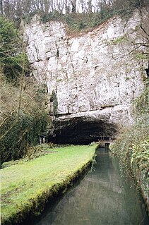
Wookey Hole Caves are a series of limestone caverns, a show cave and tourist attraction in the village of Wookey Hole on the southern edge of the Mendip Hills near Wells in Somerset, England. The River Axe flows through the cave. It is a Site of Special Scientific Interest (SSSI) for both biological and geological reasons. Wookey Hole cave is a "solutional cave", one that is formed by a process of weathering in which the natural acid in groundwater dissolves the rocks. Some water originates as rain that flows into streams on impervious rocks on the plateau before sinking at the limestone boundary into cave systems such as Swildon's Hole, Eastwater Cavern and St Cuthbert's Swallet; the rest is rain that percolates directly through the limestone. The temperature in the caves is a constant 11 °C (52 °F).

Cheddar Gorge is a limestone gorge in the Mendip Hills, near the village of Cheddar, Somerset, England. The gorge is the site of the Cheddar show caves, where Britain's oldest complete human skeleton, Cheddar Man, estimated to be 9,000 years old, was found in 1903. Older remains from the Upper Late Palaeolithic era have been found. The caves, produced by the activity of an underground river, contain stalactites and stalagmites. The gorge is part of a Site of Special Scientific Interest called Cheddar Complex.

Creswell Crags is an enclosed limestone gorge on the border between Derbyshire and Nottinghamshire, England, near the villages of Creswell and Whitwell. The cliffs in the ravine contain several caves that were occupied during the last ice age, between around 43,000 and 10,000 years ago. Its caves contain the northernmost cave art in Europe. The evidence of occupation found in the rich series of sediments that accumulated over many thousands of years is regarded as internationally unique in demonstrating how prehistoric people managed to live at the extreme northernmost limits of their territory during the Late Pleistocene period.

Timpanogos Cave National Monument is a United States National Monument protecting the Timpanogos Cave Historic District and a cave system on Mount Timpanogos in American Fork Canyon in the Wasatch Range, near Highland, Utah, in the United States. The site is managed by the National Park Service. The 1.5-mile (2.4 km) trail to the cave is steep, gaining close to 1,000 feet (300 m), but paved and fairly wide, making the caves accessible to most. The three caves of the system, one of which is specifically called Timpanogos Cave, are only viewable on guided tours when the monument is open, usually from May through September depending on snow conditions and funding. There is the standard tour going through the cave system, and an Introduction to Caving tour which teaches Leave No Trace caving and goes further into Hansen Cave.

Burrington Combe is a Carboniferous Limestone gorge near the village of Burrington, on the north side of the Mendip Hills Area of Outstanding Natural Beauty, in North Somerset, England.
Ebbor Gorge is a limestone gorge in Somerset, England, designated and notified in 1952 as a 63.5-hectare (157-acre) biological Site of Special Scientific Interest in the Mendip Hills. It was donated to the National Trust in 1967 and is now managed by Natural England as a national nature reserve.

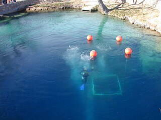
A blue hole is a large marine cavern or sinkhole, which is open to the surface and has developed in a bank or island composed of a carbonate bedrock. Their existence was first discovered in the late 20th century by fishermen and recreational divers. Blue holes typically contain tidally influenced water of fresh, marine, or mixed chemistry. They extend below sea level for most of their depth and may provide access to submerged cave passages. Well-known examples are the Dragon Hole and, in the Caribbean, the Great Blue Hole and Dean's Blue Hole.

Lost River Cave is a seven-mile cave system located in Bowling Green, Kentucky. The Lost River originates outside of the cave and flows into it. The cave contains one of the largest natural entrances in the Eastern U.S. Boat tours are available year-round, but closed for Thanksgiving Day, Christmas Eve, Christmas Day, and New Year's Day. The river was once listed by Ripley's Believe it or Not as the "Shortest, deepest river in the world" because the blue hole is over 437 feet deep, while the river itself is only 400 feet long. In fact, the blue hole is only 16 feet deep, but is linked to a further underground river. The 72-acre cave property is jointly owned by Western Kentucky University and the non-profit Friends of Lost River Cave.

Odin Mine is a disused lead mine in the Peak District National Park, situated at grid reference SK133835. It lies on a site of 25 hectares near the village of Castleton, England. It is the oldest documented mine in Derbyshire and is thought to be one of the oldest lead mines in England. The mine is a Scheduled Ancient Monument and has biological and geological significance within the Castleton Site of Special Scientific Interest.

Smoke Hole Canyon — traditionally called The Smoke Holes and later simply Smoke Hole — is a rugged 20 miles (32 km) long gorge carved by the South Branch Potomac River in the Allegheny Mountains of eastern West Virginia, United States. The area is rather isolated and remote with parts accessible only by boat or on foot.
The Blue Hole of Santa Rosa, or simply the Blue Hole, is a circular, bell-shaped pool or small lake located along Route 66 east of Santa Rosa, New Mexico that is a tourist attraction and swimming venue, and one of the most popular dive destinations in the US for scuba diving and training. The Blue Hole is an artesian well and cenóte that was once used as a fish hatchery.

Warton Crag is a limestone hill in north west Lancashire, England. It lies to the north west of Warton village, in City of Lancaster district. At 163 metres (535 ft) it is the highest point in the Arnside and Silverdale Area of Outstanding Natural Beauty, and is listed as a "HuMP" or "Hundred Metre Prominence", having a "drop" or "prominence" of 126 metres (413 ft) with its parent being Hutton Roof Crags. Two areas are Local Nature Reserves, called Warton Crag and Warton Crag Quarry. Different sections are owned by Lancashire County Council, the Wildlife Trust for Lancashire, Manchester and North Merseyside, Lancaster City Council and the Royal Society for the Protection of Birds.
The Caves of the Tullybrack and Belmore hills are a collection of caves in southwest County Fermanagh, Northern Ireland. The region is also described as the West Fermanagh Scarplands by environmental agencies and shares many similar karst features with the nearby Marble Arch Caves Global Geopark.
Devon contains some limestone areas mainly on the eastern side of Dartmoor. The River Dart has created several caves along its fringes. There are few caves with active streamways in Devon, excluding the Bakers Pit streamway. Devon also has its own species of cave shrimp.
Chudleigh Cavern is a limestone cave outside the town of Chudleigh in Devon, England. The cave is deep and contains stalactites. A small part is open to the public as a show cave. The rest is open only to experienced cavers.
Picken's Hole is a small cave on the southern side of Crook Peak in the Mendip Hills in the English county of Somerset. It has been designated as a scheduled monument. It has sometimes been confused with a nearby cave called Scragg's Hole, including by the Somerset Historic Environment Record.

Ash Hole Cavern is a limestone cave system in Brixham, Devon, England. There is evidence of human habitation since Neolithic times, and archaeological excavations have been conducted, with several artefacts found. It has been a scheduled monument since 1966.

Cow Cave is a limestone cave system which is situated on the south side of the Chudleigh Rocks, close to the town of Chudleigh, Devon, England. It is listed as a Scheduled Monument by Historic England and was first listed in 1992.
The Bockstein Cave, German: Bocksteinhöhle is part of the Bockstein complex – a White Jurassic limestone rock massif. The 15 by 20 m rock shelter, among small peripheral caves is situated around 12 m (39 ft) above the Lone River valley bottom, north of the towns of Rammingen and Öllingen, Heidenheim district in the central Swabian Jura, southern Germany. Several small openings, that are the actual entrances to the site, lead to various cave sections. The large frontal opening is of modern origin, created during the first excavation works in the late 19th century.

The Derbyshire Dome is a geological formation across mid-Derbyshire in England.

