Administrative divisions are geographical areas into which a particular independent sovereign state is divided. Such a unit usually has an administrative authority with the power to take administrative or policy decisions for its area.
A county is a geographic region of a country used for administrative or other purposes in some modern nations. The term is derived from the Old French comté denoting a jurisdiction under the sovereignty of a count (earl) or a viscount. Literal equivalents in other languages, derived from the equivalent of "count", are now seldom used officially, including comté, contea, contado, comtat, condado, Grafschaft, graafschap, and zhupa in Slavic languages; terms equivalent to 'commune' or 'community' are now often instead used.
In geography, regions, otherwise referred to as areas, zones, lands or territories, are portions of the Earth's surface that are broadly divided by physical characteristics, human impact characteristics, and the interaction of humanity and the environment. Geographic regions and sub-regions are mostly described by their imprecisely defined, and sometimes transitory boundaries, except in human geography, where jurisdiction areas such as national borders are defined in law. More confined or well bounded portions are called locations or places.
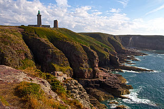
Brittany is the westernmost region of Metropolitan France. It covers about four fifths of the territory of the historic province of Brittany. It is one of two regions in Metropolitan France that do not contain any landlocked departments, the other being Corsica.

Belgium is a federal state comprising three communities and three regions that are based on four language areas. For each of these subdivision types, the subdivisions together make up the entire country; in other words, the types overlap.

A biogeographic realm is the broadest biogeographic division of Earth's land surface, based on distributional patterns of terrestrial organisms. They are subdivided into bioregions, which are further subdivided into ecoregions. A biogeographic realm is also known as "ecozone", although that term may also refer to ecoregions.
An oblast is a type of administrative division in Bulgaria and several post-Soviet states, including Belarus, Russia and Ukraine. Historically, it was used in the Russian Empire and the Soviet Union. The term oblast is often translated in English as region or province. In some countries, oblasts are also known by cognates of the Russian term.
Ecological classification or ecological typology is the classification of land or water into geographical units that represent variation in one or more ecological features. Traditional approaches focus on geology, topography, biogeography, soils, vegetation, climate conditions, living species, habitats, water resources, and sometimes also anthropic factors. Most approaches pursue the cartographical delineation or regionalisation of distinct areas for mapping and planning.

In general, a rural area or a countryside is a geographic area that is located outside towns and cities. Typical rural areas have a low population density and small settlements. Agricultural areas and areas with forestry typically are described as rural. Different countries have varying definitions of rural for statistical and administrative purposes.

Lithuania can be divided into five historical and cultural regions. The exact borders are not fully clear, as the regions are not official political or administrative units. They are delimited by culture, such as country traditions, traditional lifestyle, songs, tales, etc. To some extent, regions correspond to the zones of Lithuanian language dialects. This correspondence, however, is by no means strict. For example, although the Dzūkian dialect is called South Aukštaitian, it does not mean that Dzūkija is part of Aukštaitija. In certain parts of some regions, dialects of other regions are spoken, while for example in Samogitia, there are three indigenous dialects, some of which are subdivided into subdialects.

Western Australia (WA) is divided into regions according to a number of systems.
The country of Norway is historically divided into a number of districts. Many districts have deep historical roots, and only partially coincide with today's administrative units of counties and municipalities. The districts are defined by geographical features, often valleys, mountain ranges, fjords, plains, or coastlines, or combinations of the above. Many such regions were petty kingdoms up to the early Viking Age.

Esperance Plains, also known as Eyre Botanical District, is a biogeographic region in southern Western Australia on the south coast between the Avon Wheatbelt and Hampton bioregions, and bordered to the north by the Mallee region. It is a plain punctuated by granite and quartz outcrops and ranges, with a semi-arid Mediterranean climate and vegetation consisting mostly of mallee-heath and proteaceous scrub. About half of the region has been cleared for intensive agriculture. Recognised as a bioregion under the Interim Biogeographic Regionalisation for Australia (IBRA), it was first defined by John Stanley Beard in 1980.

Mallee, also known as Roe Botanical District, is a biogeographic region in southern Western Australia. Located between the Esperance Plains, Avon Wheatbelt and Coolgardie bioregions, it has a low, gently undulating topography, a semi-arid mediterranean climate, and extensive Eucalyptus mallee vegetation. It has an area of 73,975.59 square kilometres (28,562.13 sq mi). About half of the region has been cleared for intensive agriculture. Recognised as a region under the Interim Biogeographic Regionalisation for Australia (IBRA), it was first defined by John Stanley Beard in 1980.
In the state of New South Wales, Australia, there are many areas which are commonly known by regional names. Regions are areas that share similar characteristics. These characteristics may be natural such as the Murray River, the coastline, or the Snowy Mountains. Alternatively, the characteristics may be cultural, such as a viticulture land use. New South Wales is divided by numerous regional boundaries, based on different characteristics. In many cases boundaries defined by different agencies are coterminous.
The south coast of Western Australia comprises the Western Australian coastline from Cape Leeuwin to Eucla. This is a distance of approximately 1,600 kilometres (1,000 mi), fronting the Great Australian Bight and the Southern Ocean.

The following outline is provided as an overview of and topical guide to geography:
In the Australian state of Tasmania, there are many areas which are commonly known by regional names. Regions are areas that share similar characteristics. These characteristics may be natural such as the Furneaux Islands, the coastline, or the Central Highlands. Alternatively, the characteristics may be cultural, such as a viticulture land use. Tasmania is divided by numerous regional boundaries, based on different characteristics. In many cases boundaries defined by different government agencies are coterminous and are often cited by the Australian and local media that tend to distinguish between North West, West Coast, Southern, and East Coast.
In South Australia, one of the states of Australia, there are many areas which are commonly known by regional names. Regions are areas that share similar characteristics. These characteristics may be natural such as the Murray River, the coastline, desert or mountains. Alternatively, the characteristics may be cultural, such as common land use. South Australia is divided by numerous sets of regional boundaries, based on different characteristics. In many cases boundaries defined by different agencies are coterminous.