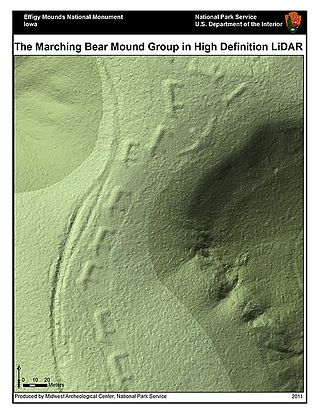
Lidar is a method for determining ranges by targeting an object or a surface with a laser and measuring the time for the reflected light to return to the receiver. lidar may operate in a fixed direction or it may scan multiple directions, in which case it is known as lidar scanning or 3D laser scanning, a special combination of 3-D scanning and laser scanning. Lidar has terrestrial, airborne, and mobile applications.
The Common Object Request Broker Architecture (CORBA) is a standard defined by the Object Management Group (OMG) designed to facilitate the communication of systems that are deployed on diverse platforms. CORBA enables collaboration between systems on different operating systems, programming languages, and computing hardware. CORBA uses an object-oriented model although the systems that use the CORBA do not have to be object-oriented. CORBA is an example of the distributed object paradigm.

Topography is the study of the forms and features of land surfaces. The topography of an area may refer to the land forms and features themselves, or a description or depiction in maps.

Remote sensing is the acquisition of information about an object or phenomenon without making physical contact with the object, in contrast to in situ or on-site observation. The term is applied especially to acquiring information about Earth and other planets. Remote sensing is used in numerous fields, including geophysics, geography, land surveying and most Earth science disciplines ; it also has military, intelligence, commercial, economic, planning, and humanitarian applications, among others.
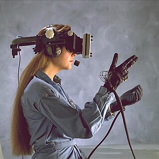
Haptic technology is technology that can create an experience of touch by applying forces, vibrations, or motions to the user. These technologies can be used to create virtual objects in a computer simulation, to control virtual objects, and to enhance remote control of machines and devices (telerobotics). Haptic devices may incorporate tactile sensors that measure forces exerted by the user on the interface. The word haptic, from the Greek: ἁπτικός (haptikos), means "tactile, pertaining to the sense of touch". Simple haptic devices are common in the form of game controllers, joysticks, and steering wheels.
Ground truth is information that is known to be real or true, provided by direct observation and measurement as opposed to information provided by inference.
Image analysis or imagery analysis is the extraction of meaningful information from images; mainly from digital images by means of digital image processing techniques. Image analysis tasks can be as simple as reading bar coded tags or as sophisticated as identifying a person from their face.
Measurement and signature intelligence (MASINT) is a technical branch of intelligence gathering, which serves to detect, track, identify or describe the distinctive characteristics (signatures) of fixed or dynamic target sources. This often includes radar intelligence, acoustic intelligence, nuclear intelligence, and chemical and biological intelligence. MASINT is defined as scientific and technical intelligence derived from the analysis of data obtained from sensing instruments for the purpose of identifying any distinctive features associated with the source, emitter or sender, to facilitate the latter's measurement and identification.

Photogrammetry is the science and technology of obtaining reliable information about physical objects and the environment through the process of recording, measuring and interpreting photographic images and patterns of electromagnetic radiant imagery and other phenomena.
Sounding or soundings may refer to:

Within the atmospheric sciences, atmospheric physics is the application of physics to the study of the atmosphere. Atmospheric physicists attempt to model Earth's atmosphere and the atmospheres of the other planets using fluid flow equations, radiation budget, and energy transfer processes in the atmosphere. In order to model weather systems, atmospheric physicists employ elements of scattering theory, wave propagation models, cloud physics, statistical mechanics and spatial statistics which are highly mathematical and related to physics. It has close links to meteorology and climatology and also covers the design and construction of instruments for studying the atmosphere and the interpretation of the data they provide, including remote sensing instruments. At the dawn of the space age and the introduction of sounding rockets, aeronomy became a subdiscipline concerning the upper layers of the atmosphere, where dissociation and ionization are important.

Multispectral imaging captures image data within specific wavelength ranges across the electromagnetic spectrum. The wavelengths may be separated by filters or detected with the use of instruments that are sensitive to particular wavelengths, including light from frequencies beyond the visible light range, i.e. infrared and ultra-violet. It can allow extraction of additional information the human eye fails to capture with its visible receptors for red, green and blue. It was originally developed for military target identification and reconnaissance. Early space-based imaging platforms incorporated multispectral imaging technology to map details of the Earth related to coastal boundaries, vegetation, and landforms. Multispectral imaging has also found use in document and painting analysis.
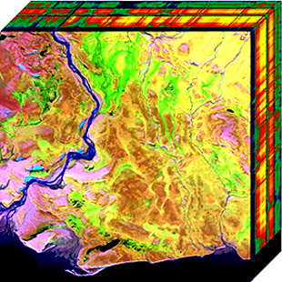
Hyperspectral imaging collects and processes information from across the electromagnetic spectrum. The goal of hyperspectral imaging is to obtain the spectrum for each pixel in the image of a scene, with the purpose of finding objects, identifying materials, or detecting processes. There are three general types of spectral imagers. There are push broom scanners and the related whisk broom scanners, which read images over time, band sequential scanners, which acquire images of an area at different wavelengths, and snapshot hyperspectral imagers, which uses a staring array to generate an image in an instant.

A photoelectric sensor is a device used to determine the distance, absence, or presence of an object by using a light transmitter, often infrared, and a photoelectric receiver. They are largely used in industrial manufacturing. There are three different useful types: opposed (through-beam), retro-reflective, and proximity-sensing (diffused).

Divergent thinking is a thought process used to generate creative ideas by exploring many possible solutions. It typically occurs in a spontaneous, free-flowing, "non-linear" manner, such that many ideas are generated in an emergent cognitive fashion. Many possible solutions are explored in a short amount of time, and unexpected connections are drawn. Following divergent thinking, ideas and information are organized and structured using convergent thinking, which follows a particular set of logical steps to arrive at one solution, which in some cases is a "correct" solution.
Atmospheric correction is the process of removing the scattering and absorption effects of the atmosphere on the reflectance values of images taken by satellite or airborne sensors. Atmospheric effects in optical remote sensing are significant and complex, dramatically altering the spectral nature of the radiation reaching the remote sensor. The atmosphere both absorbs and scatters various wavelengths of the visible spectrum which must pass through the atmosphere twice, once from the sun to the object and then again as it travels back up the image sensor. These distortions are corrected using various approaches and techniques, as described below.
The International Society for Photogrammetry and Remote Sensing (ISPRS) is an international non-governmental organization that enhances international cooperation between the worldwide organizations with interests in the photogrammetry, remote sensing and spatial information sciences. Originally named International Society for Photogrammetry (ISP), it was established in 1910, and is the oldest international umbrella organization in its field, which may be summarized as addressing “information from imagery”.
Cognition Network Technology (CNT), also known as Definiens Cognition Network Technology, is an object-based image analysis method developed by Nobel laureate Gerd Binnig together with a team of researchers at Definiens AG in Munich, Germany. It serves for extracting information from images using a hierarchy of image objects, as opposed to traditional pixel processing methods.
Middleware is a type of computer software programme that provides services to software applications beyond those available from the operating system. It can be described as "software glue".

Gaofen is a series of Chinese high-resolution Earth imaging satellites launched as part of the China High-resolution Earth Observation System (CHEOS) program. CHEOS is a state-sponsored, civilian Earth-observation program used for agricultural, disaster, resource, and environmental monitoring. Proposed in 2006 and approved in 2010, the CHEOS program consists of the Gaofen series of space-based satellites, near-space and airborne systems such as airships and UAVs, ground systems that conduct data receipt, processing, calibration, and taskings, and a system of applications that fuse observation data with other sources to produce usable information and knowledge.