Rimer, Ohio

Last updated
Houses on Road 18-R Rimer 18-R houses.jpg
Houses on Road 18-R
Location of Rimer, Ohio OHMap-doton-Rimer.png
Location of Rimer, Ohio

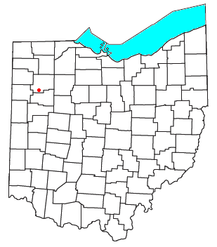
Rimer is an unincorporated community in western Sugar Creek Township, Putnam County, Ohio, United States. [1] It lies along State Route 189 between Fort Jennings and Vaughnsville.

Unincorporated area Region of land not governed by own local government

In law, an unincorporated area is a region of land that is not governed by a local municipal corporation; similarly an unincorporated community is a settlement that is not governed by its own local municipal corporation, but rather is administered as part of larger administrative divisions, such as a township, parish, borough, county, city, canton, state, province or country. Occasionally, municipalities dissolve or disincorporate, which may happen if they become fiscally insolvent, and services become the responsibility of a higher administration. Widespread unincorporated communities and areas are a distinguishing feature of the United States and Canada. In most other countries of the world, there are either no unincorporated areas at all, or these are very rare; typically remote, outlying, sparsely populated or uninhabited areas.

Sugar Creek Township, Putnam County, Ohio Township in Ohio, United States

Sugar Creek Township is one of the fifteen townships of Putnam County, Ohio, United States. The 2000 census found 1,156 people in the township.

Putnam County, Ohio county in Ohio, United States

Putnam County is a county located in the U.S. state of Ohio. As of the 2010 census, the population was 34,499. Its county seat is Ottawa. The county was created in 1820 and later organized in 1834. Its name is in honor of Israel Putnam, who was a hero in the French and Indian War and a general in the American Revolutionary War.

History

Rimer was originally called Roxburg, and under the latter name was laid out in 1881. [2] The present name is for D. P. Rimer, the original owner of the town site. [2] A post office called Rimer was in operation from 1882 until 1916. [3]

Related Research Articles

Ottawa River (Auglaize River tributary) river in the United States of America

The Ottawa River is a tributary of the Auglaize River, approximately 50 miles (80 km) long, in northwestern Ohio in the United States. The river is named for the Ottawa tribe of Native Americans who inhabited the area in the 18th century. It shares its name with another river in northwestern Ohio, the Ottawa River in Toledo, as well as the Ottawa river in Ontario & Quebec Canada.

Kieferville, Ohio human settlement in United States of America

Kieferville is an unincorporated community in Putnam County, in the U.S. state of Ohio.

North Creek is an unincorporated community in Putnam County, in the U.S. state of Ohio.

Hector is an unincorporated community in Putnam County, in the U.S. state of Ohio.

Cuba is an unincorporated community in Putnam County, in the U.S. state of Ohio.

Dorninton is an unincorporated community in Putnam County, in the U.S. state of Ohio.

Avis is an unincorporated community in Putnam County, in the U.S. state of Ohio.

Jones City is an unincorporated community in Putnam County, in the U.S. state of Ohio.

Muntanna is an unincorporated community in Putnam County, in the U.S. state of Ohio.

Huntstown is a ghost town in Putnam County, in the U.S. state of Ohio.

Douglas is an unincorporated community in Putnam County, in the U.S. state of Ohio.

Rushmore is an unincorporated community in Putnam County, in the U.S. state of Ohio.

Elm Center is an unincorporated community in Putnam County, in the U.S. state of Ohio.

Prentiss is an unincorporated community in Putnam County, in the U.S. state of Ohio.

Wisterman is an unincorporated community in Putnam County, in the U.S. state of Ohio.

Rice is an unincorporated community in Putnam County, in the U.S. state of Ohio.

New Cleveland is an unincorporated community in Putnam County, in the U.S. state of Ohio.

Cascade is a former town in Putnam County, in the U.S. state of Ohio. The GNIS classifies it as a populated place.

Hartsburg is an unincorporated community in Putnam County, in the U.S. state of Ohio.

References

Coordinates: 40°53′04″N84°12′41″W / 40.88444°N 84.21139°W / 40.88444; -84.21139

Geographic coordinate system Coordinate system

A geographic coordinate system is a coordinate system that enables every location on Earth to be specified by a set of numbers, letters or symbols. The coordinates are often chosen such that one of the numbers represents a vertical position and two or three of the numbers represent a horizontal position; alternatively, a geographic position may be expressed in a combined three-dimensional Cartesian vector. A common choice of coordinates is latitude, longitude and elevation. To specify a location on a plane requires a map projection.