
Alaska is a U.S. state on the northwest extremity of North America. A semi-exclave of the U.S., it borders British Columbia and Yukon in Canada to the east, and it shares a western maritime border in the Bering Strait with the Russian Federation's Chukotka Autonomous Okrug. To the north are the Chukchi and Beaufort Seas of the Arctic Ocean, and the Pacific Ocean lies to the south and southwest.

The Yukon River is a major watercourse of northwestern North America. From its source in British Columbia, Canada, it flows through Canada's territory of Yukon. The lower half of the river continues westward through the U.S. state of Alaska. The river is 3,190 kilometres (1,980 mi) long and empties into the Bering Sea at the Yukon–Kuskokwim Delta. The average flow is 6,400–7,000 m3/s (230,000–250,000 cu ft/s). The total drainage area is 833,000 km2 (321,500 sq mi), of which 323,800 km2 (125,000 sq mi) lies in Canada. The total area is more than 25% larger than Texas or Alberta.

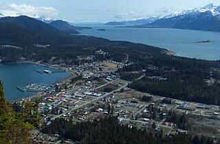
The City and Borough of Juneau, more commonly known simply as Juneau, is the capital city of the U.S. state of Alaska. Located in the Gastineau Channel and the Alaskan panhandle, it is a consolidated city-borough and the second-largest city in the United States by area. Juneau was named the capital of Alaska in 1906, when the government of what was then the District of Alaska was moved from Sitka as dictated by the U.S. Congress in 1900. The municipality unified on July 1, 1970, when the city of Juneau merged with the city of Douglas and the surrounding Greater Juneau Borough to form the current municipality, which is larger by area than both Rhode Island and Delaware.
Haines is a census-designated place located in Haines Borough, Alaska, United States. It is in the northern part of the Alaska Panhandle, near Glacier Bay National Park and Preserve.
The Alaska Highway was constructed during World War II to connect the contiguous United States to Alaska across Canada. It begins at the junction with several Canadian highways in Dawson Creek, British Columbia, and runs to Delta Junction, Alaska, via Whitehorse, Yukon. When it was completed in 1942, it was about 2,700 kilometres (1,700 mi) long, but in 2012, it was only 2,232 km (1,387 mi). This is due to the continuing reconstruction of the highway, which has rerouted and straightened many sections. The highway opened to the public in 1948. Once legendary for being a rough, challenging drive, the highway is now paved over its entire length. Its component highways are British Columbia Highway 97, Yukon Highway 1, and Alaska Route 2.

The Pan-American Highway is a network of roads stretching across the Americas and measuring about 30,000 kilometres (19,000 mi) in total length. Except for a break of approximately 106 km (66 mi) across the border between northwest Colombia and southeast Panama called the Darién Gap, the roads link almost all of the Pacific coastal countries of the Americas in a connected highway system. According to Guinness World Records, the Pan-American Highway is the world's longest "motorable road". It is only possible to cross by land between South America and Central America—the last town in Colombia to the first outpost in Panama—by a difficult and dangerous hike of at least four days through the Darién Gap, one of the rainiest areas of the planet.

A bridge to nowhere is a bridge where one or both ends are broken, incomplete, or unconnected to any roads. If it is an overpass or an interchange, the term overpass to nowhere or interchange to nowhere may be used respectively. There are five main origins for these bridges:
Route 1 is a highway in the southern part of the Canadian province of New Brunswick. It begins in the west from the Canada–United States border at St. Stephen, and runs east for 239.11 kilometres (148.58 mi) to Route 2 at River Glade.

The Alaska Railroad is a Class II railroad that operates freight and passenger trains in the state of Alaska. The railroad's mainline is over 470 miles (760 km) long and runs between Seward on the southern coast and Fairbanks, near the center of the state and the Arctic Circle, passing through Anchorage and Denali National Park where 17% of visitors arrive by train. The railroad has about 656 miles (1,056 km) of track, including sidings, rail yards and branch lines, including the branch to Whittier, where the railroad interchanges freight railcars with the contiguous United States via rail barges that sail between the Port of Whittier and Harbor Island in Seattle.
Route 2 is a major provincial highway in the Canadian province of New Brunswick, carrying the main route of the Trans-Canada Highway in the province. The highway connects with Autoroute 85 at the border with Quebec and Highway 104 at the border with Nova Scotia, as well as with traffic from Interstate 95 in the U.S. state of Maine via the short Route 95 connector. A core route in the National Highway System, Route 2 is a four-lane freeway in its entirety, and directly serves the cities of Edmundston, Fredericton, and Moncton.
The Haines Highway or Haines Cut-Off is a highway that connects Haines, Alaska, in the United States, with Haines Junction, Yukon, Canada, passing through the province of British Columbia. It follows the route of the old Dalton Trail from the port of Haines inland for about 180 km (110 mi) to Klukshu, Yukon, and then continues to Haines Junction. The highway is about 244 km (152 mi) long, of which 72 km (45 mi) is in Alaska.

The Canol Road was part of the Canol Project and was built to construct a pipeline from Norman Wells, Northwest Territories, to Whitehorse, Yukon, during World War II. The pipeline no longer exists, but the 449 kilometres (279 mi) long Yukon portion of the road is maintained by the Yukon Government during summer months. The portion of the road that still exists in the NWT is called the Canol Heritage Trail. Both road and trail are incorporated into the Trans-Canada Trail.
The Kluane First Nation (KFN) is a First Nations band government in Yukon, Canada. Its main centre is in Burwash Landing, Yukon along the Alaska Highway on the shores of Kluane Lake, the territory's largest lake. The native language spoken by the people of this First Nation is Southern Tutchone. They call themselves after the great Lake Lù’àn Män Ku Dän or Lù’àn Mun Ku Dän.

The Chilkat Pass is a mountain pass on the border of Alaska, United States, and the province of British Columbia, Canada, at the divide between the Klehini (S) and Kelsall Rivers just northwest of Haines, Alaska. At an elevation of 3510 ft, it is used by the Haines Highway and was the route used by the Dalton Trail during the days of the Klondike Gold Rush. It also marks the boundary between the Coast Mountains and Saint Elias Mountains.

Kiskatinaw Provincial Park is a provincial park located in Peace River Regional District in British Columbia, Canada. It was established on May 1, 1962 to protect a prominent horseshoe-shaped incised meander in the Kiskatinaw River where a historic curved bridge crosses the river along the original alignment of the Alaska Highway.
The Canol Project was constructed during World War II to ensure a supply of oil for the defense of Alaska and the North American west coast. The project was completed in two years at an astronomical cost and was abandoned less than a year later.

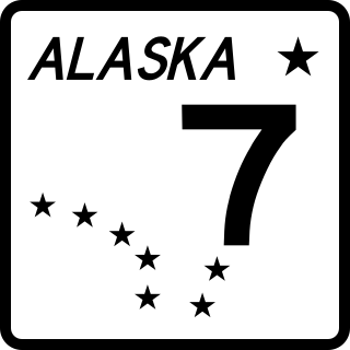
The Lynn Canal Highway, or Juneau Access Road, is a proposed road between Skagway and City and Borough of Juneau, the capital of the U.S. state of Alaska. Such a road, if built, would still require ferry access to connect Juneau to the Alaskan highway network. The new road would be 47.9 miles long, built at a cost of $574 million, and be a part of Alaska Route 7. The plan of the Alaska Department of Transportation & Public Facilities (DOT&PF) called for extending "The Road" northward from Juneau to a ferry terminal 18 miles south of Skagway. The corridor crosses Berners Bay LUD II which is a congressionally designated roadless area created by the Tongass Timber Reform Act (TTRA). The act permits crossing LUD IIs when the governor of the State of Alaska designates routes as essential transportation corridors. The proposed road skirts the shore of a northwestern section of Alaska's Inside Passage, which was recently named a National Scenic Waterway. As of 2017, the project has been indefinitely shelved due to the state's budget crisis.

The Board of Road Commissioners for Alaska, more commonly known as the Alaska Road Commission or ARC, was created in 1905 as a board of the U.S. War Department. It was responsible for the construction and improvement of many important Alaska highways, such as the Richardson Highway, Steese Highway, Elliot Highway and Edgerton Highway, among others.

The Dalton Cache–Pleasant Camp Border Crossing connects the towns of Haines, Alaska and Haines Junction, Yukon on the Canada–United States border. Alaska Route 7 on the American side joins Yukon Highway 3 on the Canadian side as part of the Haines Highway.
