Radar is a detection system that uses radio waves to determine the range, angle, or velocity of objects. It can be used to detect aircraft, ships, spacecraft, guided missiles, motor vehicles, weather formations, and terrain. A radar system consists of a transmitter producing electromagnetic waves in the radio or microwaves domain, a transmitting antenna, a receiving antenna and a receiver and processor to determine properties of the object(s). Radio waves from the transmitter reflect off the object and return to the receiver, giving information about the object's location and speed.
In telecommunications, antenna blind cone is the volume of space, usually approximately conical with its vertex at the antenna, that cannot be scanned by an antenna because of limitations of the antenna radiation pattern and mount.
A corner reflector is a retroreflector consisting of three mutually perpendicular, intersecting flat surfaces, which reflects waves directly towards the source, but translated. The three intersecting surfaces often have square shapes. Radar corner reflectors made of metal are used to reflect radio waves from radar sets. Optical corner reflectors, called corner cubes or cube corners, made of three-sided glass prisms, are used in surveying and laser ranging.
A data link is the means of connecting one location to another for the purpose of transmitting and receiving digital information. It can also refer to a set of electronics assemblies, consisting of a transmitter and a receiver and the interconnecting data telecommunication circuit. These are governed by a link protocol enabling digital data to be transferred from a data source to a data sink.

In telecommunication, a transponder is a device that, upon receiving a signal, emits a different signal in response. The term is a portmanteau of transmitter and responder. It is variously abbreviated as XPDR, XPNDR, TPDR or TP.

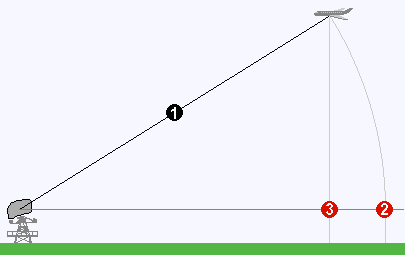
Line-of-sight propagation is a characteristic of electromagnetic radiation or acoustic wave propagation which means waves travel in a direct path from the source to the receiver. Electromagnetic transmission includes light emissions traveling in a straight line. The rays or waves may be diffracted, refracted, reflected, or absorbed by the atmosphere and obstructions with material and generally cannot travel over the horizon or behind obstacles.

A Doppler radar is a specialized radar that uses the Doppler effect to produce velocity data about objects at a distance. It does this by bouncing a microwave signal off a desired target and analyzing how the object's motion has altered the frequency of the returned signal. This variation gives direct and highly accurate measurements of the radial component of a target's velocity relative to the radar. Doppler radars are used in aviation, sounding satellites, Major League Baseball's StatCast system, meteorology, radar guns, radiology and healthcare, and bistatic radar.

Synthetic-aperture radar (SAR) is a form of radar that is used to create two-dimensional images or three-dimensional reconstructions of objects, such as landscapes. SAR uses the motion of the radar antenna over a target region to provide finer spatial resolution than conventional beam-scanning radars. SAR is typically mounted on a moving platform, such as an aircraft or spacecraft, and has its origins in an advanced form of side looking airborne radar (SLAR). The distance the SAR device travels over a target in the time taken for the radar pulses to return to the antenna creates the large synthetic antenna aperture. Typically, the larger the aperture, the higher the image resolution will be, regardless of whether the aperture is physical or synthetic – this allows SAR to create high-resolution images with comparatively small physical antennas. Additionally, SAR has the property of having larger apertures for more distant objects, allowing consistent spatial resolution over a range of viewing distances.

Distance measuring equipment (DME) is a radio navigation technology that measures the slant range (distance) between an aircraft and a ground station by timing the propagation delay of radio signals in the frequency band between 960 and 1215 megahertz (MHz). Line-of-visibility between the aircraft and ground station is required. An interrogator (airborne) initiates an exchange by transmitting a pulse pair, on an assigned 'channel', to the transponder ground station. The channel assignment specifies the carrier frequency and the spacing between the pulses. After a known delay, the transponder replies by transmitting a pulse pair on a frequency that is offset from the interrogation frequency by 63 MHz and having specified separation.
True-range multilateration is a method to determine the location of a movable vehicle or stationary point in space using multiple ranges (distances) between the vehicle/point and multiple spatially-separated known locations. The name is derived from trilateration, the geometrical problem of determining an unknown position based on the distance to other two known vertices of a triangle . True range multilateration is both a mathematical topic and an applied technique used in several fields. A practical application involving a fixed location is the trilateration method of surveying. Applications involving vehicle location are termed navigation when on-board persons/equipment are informed of its location, and are termed surveillance when off-vehicle entities are informed of the vehicle's location.
A pulse-Doppler radar is a radar system that determines the range to a target using pulse-timing techniques, and uses the Doppler effect of the returned signal to determine the target object's velocity. It combines the features of pulse radars and continuous-wave radars, which were formerly separate due to the complexity of the electronics.
The air traffic control radar beacon system (ATCRBS) is a system used in air traffic control (ATC) to enhance surveillance radar monitoring and separation of air traffic. It consists of a rotating ground antenna and transponders in aircraft. The ground antenna sweeps a narrow vertical beam of microwaves around the airspace. When the beam strikes an aircraft, the transponder transmits a return signal back giving information such as altitude and the Squawk Code, a four digit code assigned to each aircraft that enters a region. Information about this aircraft is then entered into the system and subsequently added to the controller's screen to display this information when queried. This information can include flight number designation and altitude of the aircraft. ATCRBS assists air traffic control (ATC) surveillance radars by acquiring information about the aircraft being monitored, and providing this information to the radar controllers. The controllers can use the information to identify radar returns from aircraft and to distinguish those returns from ground clutter.
A radar altimeter (RA), radio altimeter (RALT), electronic altimeter, or reflection altimeter measures altitude above the terrain presently beneath an aircraft or spacecraft by timing how long it takes a beam of radio waves to travel to ground, reflect, and return to the craft. This type of altimeter provides the distance between the antenna and the ground directly below it, in contrast to a barometric altimeter which provides the distance above a defined vertical datum, usually mean sea level. When used on aircraft, it may be known as low-range radio altimeter (LRRA).

A height finder is a ground-based aircraft altitude measuring device. Early height finders were optical range finder devices combined with simple mechanical computers, while later systems migrated to radar devices. The unique vertical oscillating motion of height finder radars led to them also being known as nodding radar. Devices combining both optics and radar were deployed by the U.S. Military.
A wind profiler is a type of weather observing equipment that uses radar or sound waves (SODAR) to detect the wind speed and direction at various elevations above the ground. Readings are made at each kilometer above sea level, up to the extent of the troposphere. Above this level there is inadequate water vapor present to produce a radar "bounce." The data synthesized from wind direction and speed is very useful to meteorological forecasting and timely reporting for flight planning. A twelve-hour history of data is available through NOAA websites.

Radio is the technology of signaling and communicating using radio waves. Radio waves are electromagnetic waves of frequency between 30 hertz (Hz) and 300 gigahertz (GHz). They are generated by an electronic device called a transmitter connected to an antenna which radiates the waves, and received by a radio receiver connected to another antenna. Radio is very widely used in modern technology, in radio communication, radar, radio navigation, remote control, remote sensing and other applications.
Moving target indication (MTI) is a mode of operation of a radar to discriminate a target against the clutter. It describes a variety of techniques used to find moving objects, like an aircraft, and filter out unmoving ones, like hills or trees. It contrasts with the modern stationary target indication (STI) technique, which uses details of the signal to directly determine the mechanical properties of the reflecting objects and thereby find targets whether they are moving or not.

The AN/CPS-6 was a medium-range search/height finder Radar used by the United States Air Force Air Defense Command.

The AN/FPS-19 was a long-range search radar developed for the NORAD Distant Early Warning Line by Raytheon. It was an L-band system working between 1220 to 1350 MHz produced by a 500 kW magnetron. Two such systems were placed back-to-back, one with an antenna that produced a narrow beam to improve range for long-range detection, and the second with a wider fan-shaped beam to cover higher angles at shorter ranges. The former could detect bomber-sized targets to about 160 miles (260 km) and the latter covered up to 65,000 ft altitude.

A cosecant squared antenna, sometimes known as a constant height pattern, is a modified form of parabolic reflector used in some radar systems. It is shaped to send more radio energy in certain directions in order to smooth out the reception pattern of objects as their range changes in relation to the radar. The name refers to the fact that the amount of energy returned from a target drops off with the square of the cosecant of the angle between the radar and the target.