
The Homestead Acts were several laws in the United States by which an applicant could acquire ownership of government land or the public domain, typically called a homestead. In all, more than 160 million acres of public land, or nearly 10 percent of the total area of the United States, was given away free to 1.6 million homesteaders; most of the homesteads were west of the Mississippi River.

The Federal Farm Loan Act of 1916 was a United States federal law aimed at increasing credit to rural family farmers. It did so by creating a federal farm loan board, twelve regional farm loan banks and tens of farm loan associations. The act was signed into law by President of the United States Woodrow Wilson.
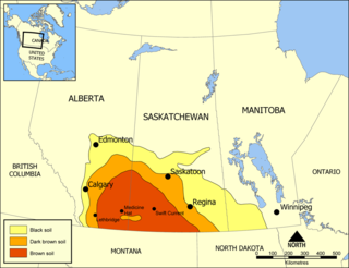
Palliser's Triangle, or the Palliser Triangle, is a semi-arid steppe occupying a substantial portion of the Western Canadian Canadian Prairies, Saskatchewan, Alberta and Manitoba, within the Great Plains region. While initially determined to be unsuitable for crops outside of the fertile belt due to arid conditions and dry climate, expansionists questioned this assessment, leading to homesteading in the Triangle. Agriculture in the region has since suffered from frequent droughts and other such hindrances.
The Dominion Land Survey is the method used to divide most of Western Canada into one-square-mile (2.6 km2) sections for agricultural and other purposes. It is based on the layout of the Public Land Survey System used in the United States, but has several differences. The DLS is the dominant survey method in the Prairie provinces, and it is also used in British Columbia along the Railway Belt, and in the Peace River Block in the northeast of the province.

The Dominion Lands Act was an 1872 Canadian law that aimed to encourage the settlement of the Canadian Prairies and to help prevent the area being claimed by the United States. The Act was closely based on the U.S. Homestead Act of 1862, setting conditions in which the western lands could be settled and their natural resources developed.

The Act of Settlement 1662 was passed by the Irish Parliament in Dublin. It was a partial reversal of the Cromwellian Act for the Settlement of Ireland 1652, which punished Irish Catholics and Royalists for fighting against the English Parliament in the Wars of the Three Kingdoms by the wholesale confiscation of their lands and property. The Act describes itself An act for the better execution of His Majesty's gracious declaration for the Settlement of his Kingdom of Ireland, and the satisfaction of the several interests of adventurers, soldiers, and other his subjects there.

Osadniks were veterans of the Polish Army and civilians who were given or sold state land in the Kresy territory ceded to Poland by Polish-Soviet Riga Peace Treaty of 1921. The Polish word was also a loanword that was used in the Soviet Union.
Section 91(2) of the Constitution Act, 1867, also known as the trade and commerce power, grants the Parliament of Canada the authority to legislate on:
2. The Regulation of Trade and Commerce.

Strongfield is a village in the Canadian province of Saskatchewan within the Rural Municipality of Loreburn No. 254 and Census Division No. 11. It lies approximately 100 km south of the City of Saskatoon on Highway 19 between its sister communities of Hawarden and Loreburn.
The Department of Soldiers' Civil Re-establishment was established by the Dominion Government of Canada in 1918 to handle the major problem of returning Canadian servicemen to civilian life after the First World War. In 1928 it merged with the Department of Health to form the Department of Pensions and National Health, with its former responsibilities being carried out by the Pensions Division.

The allotment system was a system used in Sweden for keeping a trained army at all times. This system came into use in around 1640, and was replaced by the modern Swedish Armed Forces conscription system in 1901. Two different allotment systems have been in use in Sweden; they are the old allotment system and the new allotment system, the latter often referred to as just "the allotment system". The soldiers who were part of these systems were known as "croft soldiers" due to the small crofts allotted to them.
Founded in 1921 as Australian Guarantee Company to initially provide finance for purchasers of smaller household items, it progressed into financing motor vehicles and was renamed as Australian Guarantee Corporation (AGC) in 1925. AGC was Australia's oldest national finance company offering a range of finance, investment and insurance products and were market leaders in equipment finance, cashflow finance, motor vehicle and personal finance.

Soldier settlement was the settlement of land throughout parts of Australia by returning discharged soldiers under soldier settlement schemes administered by state governments after World War I and World War II. The post-World War II settlements were co-ordinated by the Commonwealth Soldier Settlement Commission.
Land is owned in Canada by governments, Indigenous groups, corporations, and individuals. Canada is the second-largest country in the world by area; at 9,093,507 km2 or 3,511,085 mi2 of land. It occupies more than 6% of the Earth's surface.

The Group Settlement Scheme was an assisted migration scheme which operated in Western Australia from the early 1920s. It was engineered by Premier James Mitchell and followed on from the Soldier Settlement Scheme immediately after World War I. Targeting civilians and others who were otherwise ineligible for the Soldiers' scheme, its principal purpose was to provide a labour force to open up the large tracts of potential agricultural land to ultimately reduce dependence on food imports from interstate. It was also seen by Australians as boosting the ideals of the White Australia policy by strengthening the Anglo-Australian cultural identity of Australia. High levels of post-war unemployment in Britain saw the UK Government seizing on the scheme as a way to reduce dole-queues. Over 6,000 people emigrated to Western Australia under the scheme which was funded jointly by the state, federal and UK governments.

Elizabeth Métis Settlement is a Métis settlement in central Alberta, Canada within the Municipal District of Bonnyville No. 87. It was founded in 1939 after the introduction of the Metis Betterment Act. It is located approximately 20 km (12 mi) east of Highway 897 and 39 km (24 mi) south of Cold Lake and comprises 25,641 hectares of land. Industries such as oil, gas, forestry, and construction are commonly practiced by members of the settlement.

Anzac Avenue Memorial Trees is a heritage-listed memorial at Anzac Avenue, Beerburrum, Sunshine Coast Region, Queensland, Australia. It was built in 1920. It was added to the Queensland Heritage Register on 16 October 2008.

Beerburrum Soldier Settlement was a soldier settlement in Beerburrum, Queensland, Australia, established to provide opportunities for Australian soldiers returning from World War I. It is generally regarded as a failure.

The process of land selectionin Queensland in Australia began in 1860. It continued under a series of land acts in subsequent years. When Britain claimed possession of Australia, it did so based on terra nullius and did not acknowledge that Indigenous people had any ownership over the land. All land in Australia became Crown land and was sold or leased by the Australian colonial governments according to the needs of the colonists.
The Porcupine Provincial Forest is a protected boreal forest in Canada which covers the Porcupine Hills on the border of Saskatchewan and Manitoba.