
Umbria is a region of central Italy. It includes Lake Trasimeno and Marmore Falls, and is crossed by the River Tiber. It is the only landlocked region on the Apennine Peninsula. The regional capital is Perugia.
Teramo is a city and comune in the Italian region of Abruzzo, the capital of the province of Teramo.

Treia is a town and comune in the province of Macerata in the central Marche (Italy). It is 7 kilometres (4.3 mi) north of Pollenza, 12 kilometres (7.5 mi) west of Macerata, and 18 kilometres (11 mi) north-northeast of Tolentino.

Sentinum was an ancient town located in the Marche region of Italy. It was situated at low elevation about a kilometre south of the present-day town of Sassoferrato. The ruins of Sentinum were partially excavated in 1890 and the results of the archeological investigation were published by T. Buccolini.

Cosa was a Latin colony founded in southwestern Tuscany in 273 BC, on land confiscated from the Etruscans, to solidify the control of the Romans and offer the Republic a protected port. The Etruscan site may have been where modern Orbetello stands; a fortification wall in polygonal masonry at Orbetello's lagoon may be in phase with the walls of Cosa. The position of Cosa is distinct, rising some 113 metres above sea level and is sited 140 km northwest of Rome on the Tyrrhenian Sea coast, on a hill near the small town of Ansedonia. The town experienced a hard life and was never truly a prosperous Roman city, although it has assumed a position of prominence in Roman archaeology owing to the circumstances of its excavation. After the foundation, wars of the 3rd century BC affected the town. New colonists arrived in 197 BC. Cosa seems to have prospered until it was sacked in the 60s BC, perhaps by pirates - although an earthquake and unrest related to the Catilinarian Conspiracy have also been cited as reasons. This led to a re-foundation under Augustus and then life continued until the 3rd century. One of the last textual references to Cosa comes from the work of Rutilius Claudius Namatianus in his De reditu suo. In the passage 1.285-90, Rutilius remarks that by AD 417 the site of Cosa was deserted and could be seen to be in ruins. He further suggests that a plague of mice had driven the people of Cosa away.

Grumentum was an ancient Roman city in the centre of Lucania, in what is now the comune of Grumento Nova, c. 50 km (31 mi) south of Potenza by the direct road through Anxia, and 80 km (50 mi) by the Via Herculia, at the point of divergence of a road eastward to Heraclea.

Regio VI Umbria is the name for one of the 11 administrative regions into which the emperor Augustus divided Italy. The main source for the regions is the Historia Naturalis of Pliny the Elder, who informs his readers he is basing the geography of Italy on the descriptio Italiae, "division of Italy," made by Augustus. The Regio Sexta is called Umbria complexa agrumque Gallicam citra Ariminium, "Umbria including the Gallic country this side of Rimini."

Carsoli is a town and comune in the province of L'Aquila, Abruzzo. The ancient Roman city lies 4 kilometres (2.5 mi) southwest of the modern town.
Ricina or Helvia Recina was a Roman town located in the lower Potenza valley, the contemporary Italian region Marche.

Ostra is a town and comune in the Marche, central Italy, near the modern Ostra Vetere, south-east of Senigallia.

Castelleone di Suasa is a town and comune within the Province of Ancona, in the Marche region of Italy.
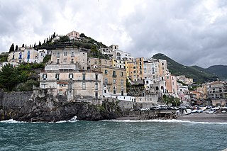
Minori is a town and a comune in the province of Salerno, in the Campania region of south-western Italy. As a part of the Amalfi Coast, it was declared a UNESCO World Heritage Site in 1997.
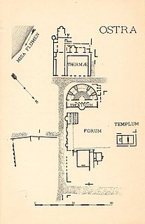
Ancient Ostra is a Roman era town situated between the modern town of Ostra Vetere the Roman town was inhabited from the 3rd century BC until the 6th century AD.

The Gilt Bronzes from Cartoceto di Pergola are the only surviving Roman gilt bronze equestrian group. The monumental ensemble was composed of at least two knights, of which only one remains, atop their horses, and two women standing. The statues are thought most likely to date between 50 and 30 BC and depict members of a prestigious local family. They were found not far from the intersection of the Via Flaminia and the Via Salaria Gallica in central Italy, in an isolated location, far from urban centres.
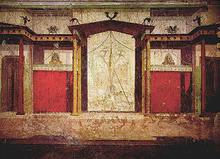
The House of Augustus, or the Domus Augusti, is situated on the Palatine Hill in Rome, Italy. This house has been identified as the primary place of residence for the emperor Augustus.

Septempeda was a Roman town in Picenum, now in the Italian region Marche. It became today's San Severino Marche after the fall of the Roman Empire.

Gino Vinicio Gentili was an Italian archaeologist.

Claternae, also called Claterna, was a Roman town on the Via Emilia situated between the coloniae of Bononia and Forum Cornelii. Like many other evenly spaced settlements on the Via Emilia, each at a day's march for the legionaries, it probably arose as a stopping place for travellers between the major towns.
Potentia was a Roman town along the central Adriatic Italian coast, near the modern town of Porto Recanati, in the province of Macerata. Its original position was just north of the main Roman bed of the River Potenza, which now flows more than 1 km (0.62 mi) to the north.

Melite or Melita was an ancient city located on the site of present-day Mdina and Rabat, Malta. It started out as a Bronze Age settlement, which developed into a city called Maleth under the Phoenicians, and became the administrative centre of the island. The city fell to the Roman Republic in 218 BC, and it remained part of the Roman and later the Byzantine Empire until 870 AD, when it was captured and destroyed by the Aghlabids. The city was then rebuilt and renamed Medina, giving rise to the present name Mdina. It remained Malta's capital city until 1530.


