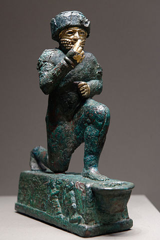
Ur was an important Sumerian city-state in ancient Mesopotamia, located at the site of modern Tell el-Muqayyar in south Iraq's Dhi Qar Governorate. Although Ur was once a coastal city near the mouth of the Euphrates on the Persian Gulf, the coastline has shifted and the city is now well inland, on the south bank of the Euphrates, 16 km (10 mi) from Nasiriyah in modern-day Iraq. The city dates from the Ubaid period circa 3800 BC, and is recorded in written history as a city-state from the 26th century BC, its first recorded king being Mesannepada.
Eridu was a Sumerian city located at Tell Abu Shahrain, also Abu Shahrein or Tell Abu Shahrayn, an archaeological site in southern Mesopotamia. It is located in Dhi Qar Governorate, Iraq near the modern city of Basra. Eridu is traditionally believed to be the earliest city in southern Mesopotamia based on the Sumerian King List. Located 12 kilometers southwest of the ancient site of Ur, Eridu was the southernmost of a conglomeration of Sumerian cities that grew around temples, almost in sight of one another. The city gods of Eridu were Enki and his consort Damkina. Enki, later known as Ea, was considered to have founded the city. His temple was called E-Abzu, as Enki was believed to live in Abzu, an aquifer from which all life was believed to stem. According to Sumerian temple hymns another name for the temple of Ea/Enki was called Esira (Esirra).
"... The temple is constructed with gold and lapis lazuli, Its foundation on the nether-sea (apsu) is filled in. By the river of Sippar (Euphrates) it stands. O Apsu pure place of propriety, Esira, may thy king stand within thee. ..."

Sumer is the earliest known civilization in the historical region of southern Mesopotamia, emerging during the Chalcolithic and early Bronze Ages between the sixth and fifth millennium BC. Like nearby Elam, it is one of the cradles of civilization, along with Egypt, the Indus Valley, the Erligang culture of the Yellow River valley, Caral-Supe, and Mesoamerica. Living along the valleys of the Tigris and Euphrates rivers, Sumerian farmers grew an abundance of grain and other crops, a surplus which enabled them to form urban settlements. The world's earliest known texts come from the Sumerian cities of Uruk and Jemdet Nasr, and date to between c. 3350 – c. 2500 BC, following a period of proto-writing c. 4000 – c. 2500 BC.
Larsa, also referred to as Larancha/Laranchon by Berossos and connected with the biblical Ellasar, was an important city-state of ancient Sumer, the center of the cult of the sun god Utu. It lies some 25 km (16 mi) southeast of Uruk in Iraq's Dhi Qar Governorate, near the east bank of the Shatt-en-Nil canal at the site of the modern settlement Tell as-Senkereh or Sankarah.
Kish is an important archaeological site in Babil Governorate (Iraq), located 80 kilometers south of Baghdad and 12 kilometers east of the ancient city of Babylon. The Ubaid period site of Ras al-Amiyah is 8 kilometers away. It was occupied from the Ubaid to Hellenistic periods. In Early Dynastic times the city's patron deity was Ishtar with her consort Ea. Her temple, at Tell Ingharra, was (E)-hursag-kalama. By Old Babylonian times the patron deities had become Zababa, along with his consort, the goddess Bau and Istar. His temple Emeteursag was at Uhaimir.
The Ubaid period is a prehistoric period of Mesopotamia. The name derives from Tell al-'Ubaid where the earliest large excavation of Ubaid period material was conducted initially in 1919 by Henry Hall and later by Leonard Woolley.
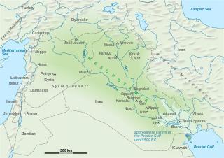
The history of Mesopotamia ranges from the earliest human occupation in the Paleolithic period up to Late antiquity. This history is pieced together from evidence retrieved from archaeological excavations and, after the introduction of writing in the late 4th millennium BC, an increasing amount of historical sources. While in the Paleolithic and early Neolithic periods only parts of Upper Mesopotamia were occupied, the southern alluvium was settled during the late Neolithic period. Mesopotamia has been home to many of the oldest major civilizations, entering history from the Early Bronze Age, for which reason it is often called a cradle of civilization.

Jemdet Nasr is a tell or settlement mound in Babil Governorate (Iraq) that is best known as the eponymous type site for the Jemdet Nasr period, and was one of the oldest Sumerian cities. The site was first excavated in 1926 by Stephen Langdon, who found Proto-Cuneiform clay tablets in a large mudbrick building thought to be the ancient administrative centre of the site. A second season took place in 1928, but this season was very poorly recorded. Subsequent excavations in the 1980s under British archaeologist Roger Matthews were, among other things, undertaken to relocate the building excavated by Langdon. These excavations have shown that the site was also occupied during the Ubaid, Uruk and Early Dynastic I periods. Based on texts found there mentioning an ensi of NI.RU that is thought to be it's ancient name.

Girsu was a city of ancient Sumer, situated some 25 km (16 mi) northwest of Lagash, at the site of modern Tell Telloh, Dhi Qar Governorate, Iraq.

Zabala, also Zabalam was a city of ancient Sumer in Mesopotamia, located in what is now the Dhi Qar governorate in Iraq. In early archaeology this location was also called Tel el-Buzekh. Locally it is called Tell Bzikh. Zabala was at the crossing of the ancient Iturungal and Ninagina canals, 10 kilometers to the northwest of Umma. The city's deity was Inanna of Zabala. A cuneiform tablet from Zabala contains one of only a few metro-mathematical tables of area measures from the Early Dynastic Period.

The Samarra culture is a Late Neolithic archaeological culture of northern Mesopotamia, roughly dated to between 5500 and 4800 BCE. It partially overlaps with Hassuna and early Ubaid. Samarran material culture was first recognized during excavations by German Archaeologist Ernst Herzfeld at the site of Samarra. Other sites where Samarran material has been found include Tell Shemshara, Tell es-Sawwan, and Yarim Tepe.
Tell es-Sawwan is an important Samarran period archaeological site in Saladin Province, Iraq. It is located 110 kilometres (68 mi) north of Baghdad, and south of Samarra. It lies on a 12 meter high cliff overlooking the Tigris River.
Choghā Mīsh (Persian language; چغامیش čoġā mīš) dating back to about 6800 BC, is the site of a Chalcolithic settlement located in the Khuzistan Province Iran on the eastern Susiana Plain. It was occupied at the beginning of 6800 BC and continuously from the Neolithic up to the Proto-Literate period, thus spanning the time periods from Archaic through Proto-Elamite period. After the decline of the site about 4400 BC, the nearby Susa, on the western Susiana Plain, became culturally dominant in this area. Chogha Mish is located just to the east of Dez River, and about 25 kilometers to the east from the ancient Susa. The similar, though much smaller site of Chogha Bonut lies six kilometers to the west.
Choga Mami is a Samarran settlement site in Diyala province in Eastern Iraq in the Mandali region. It shows the first canal irrigation in operation at about 6000 BCE.

Tell al-'Ubaid is a low, relatively small tell west of nearby Ur in southern Iraq's Dhi Qar Governorate. The majority of the remains are from the Chalcolithic Ubaid period, for which Tell al-'Ubaid is the type site, with an Early Dynastic temple and cemetery at the highest point. It was a cult center for the goddess Ninhursag.
Tell Khaiber is a tell, or archaeological settlement mound, in southern Mesopotamia. It is located thirteen kilometers west of the modern city of Nasiriyah, about 19 kilometers northwest of the ancient city of Ur in Dhiq Qar Province and 25 kilometers south of the ancient city of Larsa. In 2012, the site was visited by members of the Ur Region Archaeology Project (URAP), a cooperation between the British Institute for the Study of Iraq, the University of Manchester and the Iraqi State Board for Antiquities and Heritage. They found that the site had escaped looting, and applied for an excavation permit.
Tell Rashid is a tell, or archaeological settlement mound, in Diyala Governorate, Iraq. The site lies in the foothills of the Zagros Mountains, some 12 km (7.5 mi) south of Tell Abada, another Ubaid period site. It measures 54 by 30 m and extends 2.5 m above the surrounding plain. Tell Rashid was excavated for a single season in 1978 under the direction of Sabah Abboud Jasim as part of the archaeological salvage work being done for the construction of the Hemrin Dam. The excavation trench reached a depth of 5 m, at which point virgin soil was reached. Four different occupation levels were recognised, all dating to the Ubaid period.
Tell Abada is a tell, or archaeological settlement mound, in Diyala Governorate (Iraq). Abada was excavated as part of the archaeological salvage operation to excavate sites that would be flooded by the reservoir of the Hamrin Dam. Excavations revealed occupation levels dating to the Ubaid 1-3 periods. The site is important because it was one of the few where an Ubaid period settlement could be excavated in its entirety.
Ginnig is a tell in Upper Mesopotamia that was occupied at the transition from the PPNB to the Pottery Neolithic.
Tell Zurghul, also spelled Tell Surghul, is an archaeological site in Dhi Qar Governorate (Iraq). It lies on an ancient canal leading from Lagash of which is lies 10 km to the south-east. Its ancient name was the cuneiform read as Niĝin. The city god was Nanshe (Nanše), who had temples there (E-sirara) and at nearby Girsu. She was the daughter of Enki and sister of Ningirsu and Nisaba. Niĝin, along with the cities of Girsu and Lagash, was part of the State of Lagash in the later part of the 3rd Millennium BC.
