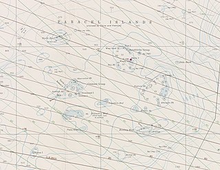
The Paracel Islands, also known as the Xisha Islands and the Hoàng Sa Archipelago, are a disputed archipelago in the South China Sea.
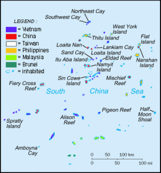
The Spratly Islands are a disputed archipelago in the South China Sea. Composed of islands, islets, cays, and more than 100 reefs, sometimes grouped in submerged old atolls, the archipelago lies off the coasts of the Philippines, Malaysia, and southern Vietnam. Named after the 19th-century British whaling captain Richard Spratly who sighted Spratly Island in 1843, the islands contain less than 2 km2 of naturally occurring land area, which is spread over an area of more than 425,000 km2 (164,000 sq mi).
The term One China may refer, in alphabetical order, to one of the following:
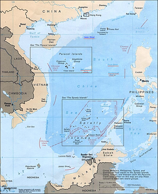
The South China Sea Islands consist of over 250 islands, atolls, cays, shoals, reefs and seamounts in the South China Sea. The islands are mostly low and small and have few inhabitants. The islands and surrounding seas are subject to overlapping territorial claims by the countries bordering the South China Sea.

Zhenbao Island or Damansky Island is an island in Hulin, Jixi, Heilongjiang Province, China, with an area of only 0.74 square kilometres (0.29 sq mi). It is on the Ussuri River on the border between Primorsky Krai, Russia, and Heilongjiang Province, China.
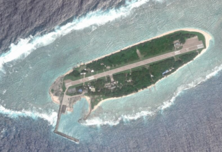
Taiping Island, also known as Itu Aba, and various other names, is the largest of the naturally occurring Spratly Islands in the South China Sea. The island is elliptical in shape being 1.4 kilometres (0.87 mi) in length and 0.4 kilometres (0.25 mi) in width, with an area of 46 hectares. It is located on the northern edge of the Tizard Bank. The runway of the Taiping Island Airport is easily the most prominent feature on the island, running its entire length.
The 1991 Sino–Soviet Border Agreement was a treaty signed between China and the Soviet Union on May 16, 1991. It set up demarcation work to resolve most of the border disputes between the two states. Initially signed by China and the Soviet Union, the terms of the agreement were resumed by Russia after the dissolution of the Soviet Union. The treaty resulted in some minor territorial changes along the border.

Bolshoi Ussuriysky Island, or Heixiazi Island, is a sedimentary island at the confluence of the Ussuri and Amur rivers. It is disputed between the People's Republic of China (PRC) and the Russian Federation (RF). It has an area of about 327 to 350 km2 and is bounded closely by Yinlong/Tarabarov Island, and over 90 islets. Its position at the confluence of the Amur and the Ussuri, and right next to the major Russian city of Khabarovsk, has given it great strategic importance.
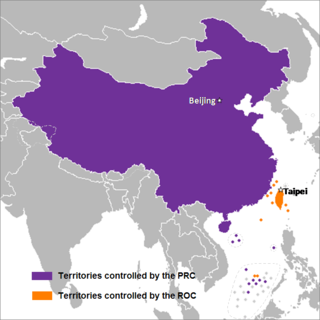
The term "Two Chinas" refers to the geopolitical situation where two political entities exist under the name "China".

Sansha City is a prefecture-level city under the Hainan province of the People's Republic of China (PRC), and is the southernmost and least populated prefecture in China, with the smallest land area but the largest maritime territory. The city's seat is located on Yongxing Island in the South China Sea, and administers several island groups, atolls, seamounts and a number of other ungrouped maritime features within the nine-dash line, although the PRC's de facto control over the area varies. The name "Sansha", literally meaning "three sands", refers to the three archipelago districts of Xisha, Zhongsha and Nansha.
The Spratly Islands dispute is an ongoing territorial dispute between Brunei, China, Malaysia, the Philippines, Taiwan, and Vietnam concerning "ownership" of the Spratly Islands, a group of islands and associated "maritime features" located in the South China Sea. The dispute is characterized by diplomatic stalemate and the employment of military pressure techniques in the advancement of national territorial claims. All except Brunei occupy some of the maritime features.

Territorial disputes in the South China Sea involve conflicting island and maritime claims in the South China Sea by several sovereign states, namely the People's Republic of China (PRC), Taiwan, Brunei, Malaysia, the Philippines, Vietnam and Indonesia. The disputes involve the islands, reefs, banks, and other features of the region, including the Spratly Islands, Paracel Islands, Scarborough Shoal, and various boundaries in the Gulf of Tonkin. The waters near the Indonesian Natuna Islands, which some regard as geographically part of the South China Sea, are disputed as well.
The Chinese–Russian border or the Sino-Russian border is the international border between China and Russia. After the final demarcation carried out in the early 2000s, it measures 4,209.3 kilometres (2,615.5 mi), and is the world's sixth-longest international border. According to the Russian border agency, as of October 1, 2013, there are more than 160 land border crossings between Russia and China, all of these border crossings are open 24 hours. There are crossing points established by the treaty including railway crossings, highway crossings, river crossing, and mostly ferry crossings.

Japan is currently engaged in several territorial disputes with nearby countries, including Russia, South Korea, North Korea, the People's Republic of China, and the Republic of China (Taiwan).

Vietnam claims an exclusive economic zone (EEZ) of 1,395,096 km2 (538,650 sq mi) with 200 nautical miles from its shores.

Chinese irredentism involves irredentist claims to the territories of former Chinese dynasties made by the Republic of China (ROC) and subsequently the People's Republic of China (PRC).

This article is about territorial disputes of the People's Republic of China (PRC). A territorial dispute is a disagreement over the possession or control of land between two or more political entities. Many of these territorial disputes are almost identical to those that the Republic of China (ROC) based in Taipei, also known as Taiwan, has with other countries. Therefore, many of the subsequent resolved disputes made by the PRC after 1949 with other governments may not be recognized by the ROC.
The following is a topical outline of English Wikipedia articles about the military history of the People's Republic of China. It includes the military events, individuals, and topics involving the People's Republic of China from the Chinese Civil War to the present. The events are outlined chronologically with topical subsections.
