Tolicha Peak

Last updated

Tolicha Peak is a summit in the U.S. state of Nevada. [1] The elevation is 6,870 feet (2,090 m). [1]

Summit A point on a surface that is higher in elevation than all points immediately adjacent to it, in topography

A summit is a point on a surface that is higher in elevation than all points immediately adjacent to it. Mathematically, a summit is a local maximum in elevation. The topographic terms acme, apex, peak, and zenith are synonymous.

U.S. state constituent political entity of the United States

In the United States, a state is a constituent political entity, of which there are currently 50. Bound together in a political union, each state holds governmental jurisdiction over a separate and defined geographic territory and shares its sovereignty with the federal government. Due to this shared sovereignty, Americans are citizens both of the federal republic and of the state in which they reside. State citizenship and residency are flexible, and no government approval is required to move between states, except for persons restricted by certain types of court orders. Four states use the term commonwealth rather than state in their full official names.

Nevada State of the United States of America

Nevada is a state in the Western United States. It is bordered by Oregon to the northwest, Idaho to the northeast, California to the west, Arizona to the southeast and Utah to the east. Nevada is the 7th most extensive, the 32nd most populous, but the 9th least densely populated of the U.S. states. Nearly three-quarters of Nevada's people live in Clark County, which contains the Las Vegas–Paradise metropolitan area where three of the state's four largest incorporated cities are located. Nevada's capital, however, is Carson City.

Tolicha is a name derived from the Yokutsan languages. [2]

Yokutsan languages endangered language family spoken in the interior of Northern and Central California in and around the San Joaquin Valley by the Yokut people

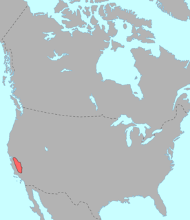
Yokutsan is an endangered language family spoken in the interior of Northern and Central California in and around the San Joaquin Valley by the Yokut people. The speakers of Yokutsan languages were severely affected by disease, missionaries, and the Gold Rush. While descendants of Yokutsan-family speakers currently number in the thousands, most of the constituent languages are now extinct.

Related Research Articles

Why, Arizona community in Arizona

Why is a tiny unincorporated rural community in Pima County, Arizona, United States. It lies near the western border of the Tohono O'Odham Indian Reservation and due north of Organ Pipe Cactus National Monument in Southern Arizona. It is approximately 30 miles (48 km) north of the Mexican border where Lukeville, Arizona, and Sonoyta, Sonora, Mexico, border each other, and 10 miles (16 km) south of Ajo, Arizona.

Scottys Junction, Nevada town

Scotty's Junction is an unincorporated community in the Sarcobatus Flat of Nye County, Nevada where State Route 267 meets with U.S. Route 95 at an elevation of 4,062 feet (1,238 m).

Cactus Range

The Cactus Range is a small mountain range in Nye County, Nevada. The range lies southwest of Cactus Flat and north of Pahute Mesa. Goldfield lies 23 mi (37 km) to the west in Esmeralda County. The range lies within the restricted area of the Tonopah Test Range.

Montezuma Creek is a tributary of the San Juan River. The river is approximately 73 miles (117 km) long and is a seasonal river, becoming dry for several months of the year.

Pahute Mesa (landform)

The Pahute Mesa (landform) is a large, 60 miles (97 km) long mesa in southern Nye County, Nevada. The mesa's southeast region lies in the Nevada Test Site which is southeast; the region in the test site is called Pahute Mesa, one of the major test site sub-regions.

Marshall Heights is an unincorporated community in Gloucester County, in the U. S. state of Virginia.

Rainier Mesa

Rainier Mesa is one of four major nuclear test regions within the Nevada National Security Site (NNSS). It occupies approximately 40 square miles (100 km2) along the northern edge of the NNSS and corresponds to Area 12.

Tongue Wash is a wash in Nye County, Nevada, in the United States.

Excelsior is a ghost town in Elko County, in the U.S. state of Nevada.

Silurian Valley is a valley in the Mojave Desert, in San Bernardino County, California. The valley trends in a north-south direction, its mouth located just southeast of the south end of Death Valley at 35°37′17″N116°16′07″W. Its head is at 35°23′36″N116°08′02″W. The valley is drained by Salt Creek a tributary of the Amargosa River and contains Silurian Lake and Dry Sand Lake.

Junior Furnace is an unincorporated community in Scioto County, in the U.S. state of Ohio.

Beaver Peak is a summit in the U.S. state of Nevada. The elevation is 8,783 feet (2,677 m).

Hat Peak is a summit in the U.S. state of Nevada. The elevation is 5,886 feet (1,794 m).

Antelope Peak is a summit in the U.S. state of Nevada. The elevation is 10,223 feet (3,116 m).

Western Peak is a summit in the U.S. state of Nevada. The elevation is 8,835 feet (2,693 m).

Amos is an unincorporated community in Humboldt County, in the U.S. state of Nevada.

National is an extinct town in Humboldt County, in the U.S. state of Nevada.

Highland Peak is a summit in the U.S. state of Nevada. The elevation is 9,337 feet (2,846 m).

Hat Peak is a summit in the U.S. state of Nevada. The elevation is 8,625 feet (2,629 m).

Quartzite Mountain is a summit in the U.S. state of Nevada. The elevation is 7,762 feet (2,366 m).

References