The Upper Thames River Conservation Authority is a body based in London, Ontario, Canada. It was created in 1947. It was responsible for the construction of the Fanshawe Dam, completed in the 1950s, to control flooding from the Thames River, which runs through London. During the last ice age, the site of London was the terminus of a large glacier. When the region warmed at the end of the ice age, the glacier melted and receded North, leaving behind a drainage ditch and features such as Sifton Bog. As such, the Thames is a watershed for most of Western Ontario, and is therefore highly susceptible to seasonal flooding. In 1937, such flooding had devastating consequences, destroying over 1,000 homes, and causing millions of dollars in damage.
Today, the Upper Thames River Conservation Authority is mainly a not-for-profit agency which monitors flora and fauna welfare in the area and gives tours to local kids on school field trips. As of 2023, the current headquarters for the UTRCA is next to Fanshawe Lake at the Fanshawe Conservation Area.
Conservation areas
The Upper Thames River Conservation Authority manages three conservation areas:
Ellice Swamp is a Class 2 Provincially Significant wetland and largest wetland in the watershed.
Dorchester Swamp, is a Class 1 wetland east of London attached to the Dorchester Mill Pond. It is a designated as an Area of Natural and Scientific Interest (ANSI) and a Carolinian Canada site. This swamp is 548 hectares is size.
Sifton Bog, which is a Class 2 wetland within the City of London, is considered the most southerly intact bog in Canada.
Golspie Swamp, northwest of Woodstock, is one of the largest remaining wooded areas in Oxford County.
London is a city in southwestern Ontario, Canada, along the Quebec City–Windsor Corridor. The city had a population of 422,324 according to the 2021 Canadian census. London is at the confluence of the Thames River, approximately 200 km (120 mi) from both Toronto and Detroit; and about 230 km (140 mi) from Buffalo, New York. The city of London is politically separate from Middlesex County, though it remains the county seat.
A swamp is a forested wetland. Swamps are considered to be transition zones because both land and water play a role in creating this environment. Swamps vary in size and are located all around the world. The water of a swamp may be fresh water, brackish water, or seawater. Freshwater swamps form along large rivers or lakes where they are critically dependent upon rainwater and seasonal flooding to maintain natural water level fluctuations. Saltwater swamps are found along tropical and subtropical coastlines. Some swamps have hammocks, or dry-land protrusions, covered by aquatic vegetation, or vegetation that tolerates periodic inundation or soil saturation. The two main types of swamp are "true" or swamp forests and "transitional" or shrub swamps. In the boreal regions of Canada, the word swamp is colloquially used for what is more formally termed a bog, fen, or muskeg. Some of the world's largest swamps are found along major rivers such as the Amazon, the Mississippi, and the Congo.
The Don River is a watercourse in southern Ontario that empties into Lake Ontario, at Toronto Harbour. Its mouth was just east of the street grid of the town of York, Upper Canada, the municipality that evolved into Toronto, Ontario. The Don is one of the major watercourses draining Toronto that have headwaters in the Oak Ridges Moraine.
The Mississippi River is a tributary of the Ottawa River in Eastern Ontario, Canada which has no relation with the Mississippi River in the United States. It is 200 kilometres (120 mi) in length from its source at Mackavoy Lake, has a drainage area of 4,450 square kilometres (1,720 sq mi), and has a mean discharge of 40 cubic metres per second (1,400 cu ft/s). There are more than 250 lakes in the watershed.
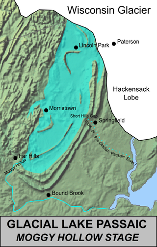
Lake Passaic was a prehistoric proglacial lake that existed in northern New Jersey in the United States at the end of the last ice age approximately 19,000–14,000 years ago. The lake was formed of waters released by the retreating Wisconsin Glacier, which had pushed large quantities of earth and rock ahead of its advance, blocking the previous natural drainage of the ancestral Passaic River through a gap in the central Watchung Mountains. The lake persisted for several thousand years as melting ice and eroding moraine dams slowly drained the former lake basin. The effect of the lake's creation permanently altered the course of the Passaic River, forcing it to take a circuitous route through the northern Watchung Mountains before spilling out into the lower piedmont.
Pottageville is an unincorporated community located in northeastern King Township, in Ontario, Canada. It is near Schomberg. It is named for one of its early settlers, Edward Pottage.
A conservation authority is a local, community-based natural resource management agency based in Ontario, Canada. Conservation authorities represent groupings of municipalities on a watershed basis and work in partnership with other agencies to carry out natural resource management activities within their respective watersheds, on behalf of their member municipalities and the Province of Ontario.
Rouge National Urban Park is a national urban park in Ontario, Canada. The park is centred around the Rouge River and its tributaries in the Greater Toronto Area. The southern portion of the park is situated around the mouth of river in Toronto, and extends northwards into Markham, Pickering, Uxbridge, and Whitchurch-Stouffville.
The Thames River is located in southwestern Ontario, Canada.
Fanshawe Dam is a dam located on North Thames River near the eastern edge of London, Ontario. The crest of the dam is 625 metres long. It is 30.5 metres in height and drops the river surface 12 metres. Fanshawe Lake is the reservoir created by the dam. The hydroelectric generator of the Fanshawe Dam generates enough power to run 400 households. It is one of three dams on the Thames River and its tributaries.
Minesing Wetlands, previously known as Minesing Swamp, is a Ramsar boreal wetland in central Ontario, Canada stretching from the western periphery of Barrie to Georgian Bay. It was identified and classified through the International Biological Program. It is "the largest and best example of fen bog in southern Ontario", one of the "most diverse undisturbed wetland tracts in Canada" and is a provincially significant Area of Natural and Scientific Interest. The term minesing is of Ojibwe origin and means "island", referring to an island located within Lake Edenvale, which encompassed the present-day wetlands and surrounding areas.
Medway Creek is a tributary of the Thames River in southwestern Ontario, Canada, draining into the North branch of the Thames at the University of Western Ontario.
The Pittock Dam is a dam in Woodstock, Ontario, Canada. It lies on the main branch of the Thames River, and creates the Pittock Reservoir. This artificial lake forms the northeast boundary of the City of Woodstock.
Wildwood Dam is a dam located on Trout Creek in Perth South, Ontario, which flows into the North Thames River in the Town of St. Marys. Wildwood Dam is designed for flood control and flow augmentation purposes.
The Sifton Bog Environmentally Significant Area is a wetland jointly administered by the city of London, Ontario and the Upper Thames River Conservation Authority. It is located west of Hyde Park Road and south of Oxford Street inside the city limits of London, Southern Ontario, Canada. It is a Class 2 provincially significant wetland.
The Huron Tract Purchase also known as the Huron Block, registered as Crown Treaty Number 29, is a large area of land in southwestern Ontario bordering on Lake Huron to the west and Lake Erie to the east. The area spans the counties of Huron, Perth, Middlesex and present day Lambton County, Ontario in the province of Ontario.
Ellice Swamp is a large woodlot in Perth County, Ontario. The swamp covers approximately 856 hectares. It is located between Stratford and Milverton in the northeastern portion of the Thames River Watershed, between the North Branch of the Thames and the Nith River.
Fanshawe Pioneer Village is an open-air museum established in 1959 and located in the Fanshawe Conservation Area in London, Ontario. The village uses historical re-enactments to communicate the history of rural communities in the former townships of Westminster, London, North Dorchester, Delaware, West Nissouri and Lobo in Middlesex County from 1820 to 1920 and the founding and development of the City of London up to 1840.
The Saugeen Valley Conservation Authority (SVCA) is a conservation authority in Ontario, Canada. It operates under the Conservation Authorities Act of Ontario. It is a corporate body, through which municipalities, landowners and other organizations work cooperatively to manage the Saugeen River watershed and natural resources within it.
This page is based on this Wikipedia article Text is available under the CC BY-SA 4.0 license; additional terms may apply. Images, videos and audio are available under their respective licenses.