Albosaggia is a comune (municipality) in the Province of Sondrio in the Italian region Lombardy, located about 90 kilometres (56 mi) northeast of Milan and about 2 kilometres (1 mi) southwest of Sondrio. As of 31 December 2004, it had a population of 3,135 and an area of 34.3 square kilometres (13.2 sq mi).
Andalo Valtellino is a comune (municipality) in the Province of Sondrio in the Italian region Lombardy, located about 80 kilometres (50 mi) northeast of Milan and about 30 kilometres (19 mi) west of Sondrio.
Bianzone is a comune (municipality) in the Province of Sondrio in the Italian region Lombardy, located about 110 kilometres (68 mi) northeast of Milan and about 20 kilometres (12 mi) east of Sondrio, on the border with Switzerland. As of 31 December 2004, it had a population of 1,250 and an area of 17.3 square kilometres (6.7 sq mi).
Caiolo is a comune (municipality) in the Province of Sondrio in the Italian region Lombardy, located about 90 kilometres (56 mi) northeast of Milan and about 5 kilometres (3 mi) southwest of Sondrio. As of 31 December 2004, it had a population of 994 and an area of 33.3 square kilometres (12.9 sq mi).

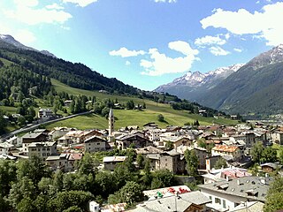
Chiesa in Valmalenco is a comune (municipality) in the Province of Sondrio in the Italian region Lombardy, located about 100 kilometres (62 mi) northeast of Milan and about 11 kilometres (7 mi) north of Sondrio, on the border with Switzerland. The English for "Chiesa in Valmalenco" is "Valmalenco's Chapel": it is the most important village of the Valmalenco valley . The area near Chiesa in Valmalenco is famous for alpine skiing and the particular geology of the surrounding mountains. As of 31 December 2004, it had a population of 2,714 and an area of 114.8 square kilometres (44.3 sq mi).
Chiuro is a comune (municipality) in the Province of Sondrio in the Italian region Lombardy, located about 100 kilometres (62 mi) northeast of Milan and about 9 kilometres (6 mi) east of Sondrio, on the border with Switzerland. As of 31 December 2004, it had a population of 2,499 and an area of 51.8 square kilometres (20.0 sq mi).
Cosio Valtellino is a comune (municipality) in the Province of Sondrio in the Italian region Lombardy, located about 80 kilometres (50 mi) northeast of Milan and about 25 kilometres (16 mi) west of Sondrio.

Gordona is a comune (municipality) in the Province of Sondrio in the Italian region Lombardy, located about 90 kilometres (56 mi) north of Milan and about 40 kilometres (25 mi) northwest of Sondrio, on the border with Switzerland. As of 31 December 2004, it had a population of 1,770 and an area of 49.0 square kilometres (18.9 sq mi).
Grosotto is a comune (municipality) in the Province of Sondrio in the Italian region Lombardy, located about 120 kilometres (75 mi) northeast of Milan and about 35 kilometres (22 mi) northeast of Sondrio, on the border with Switzerland.
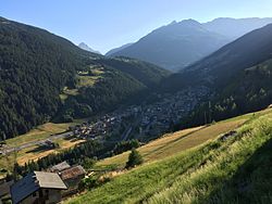
Lanzada is a comune (municipality) in the Province of Sondrio in the Italian region Lombardy, located about 150 kilometres (93 mi) northeast of Milan and 18 kilometres (11 mi) north of Sondrio, on the border with Switzerland. As of 31 December 2004, it had a population of 1,445 and an area of 116.1 square kilometres (44.8 sq mi).
Mazzo di Valtellina is a comune (municipality) in the Province of Sondrio in the Italian region Lombardy, located about 120 kilometres (75 mi) northeast of Milan and about 30 kilometres (19 mi) northeast of Sondrio. As of 31 December 2004, it had a population of 1,075 and an area of 15.4 square kilometres (5.9 sq mi).

Montagna in Valtellina is a comune (municipality) in the Province of Sondrio in the Italian region Lombardy, located about 100 kilometres (62 mi) northeast of Milan and about 3 kilometres (2 mi) northeast of Sondrio.

Teglio is a comune (municipality) in the Province of Sondrio in the Italian region Lombardy, located about 130 kilometres (81 mi) northeast of Milan and about 20 kilometres (12 mi) east of Sondrio, on the border with Switzerland.
Traona is a comune (municipality) in the Province of Sondrio in the Italian region Lombardy, located about 80 kilometres (50 mi) northeast of Milan and about 25 kilometres (16 mi) west of Sondrio. As of 31 December 2004, it had a population of 2,314 and an area of 6.2 square kilometres (2.4 sq mi).
Valdisotto is a comune (municipality) in the Province of Sondrio in the Italian region Lombardy, located about 140 kilometres (87 mi) northeast of Milan and about 45 kilometres (28 mi) northeast of Sondrio.
Val Masino is a comune (municipality) in the Province of Sondrio in the Italian region Lombardy, located about 90 kilometres (56 mi) northeast of Milan and about 20 kilometres (12 mi) northwest of Sondrio, on the border with Switzerland. As of 31 December 2004, it had a population of 962 and an area of 116.0 square kilometres (44.8 sq mi).
Vervio is a comune (municipality) in the Province of Sondrio in the Italian region Lombardy, located about 120 kilometres (75 mi) northeast of Milan and about 30 kilometres (19 mi) northeast of Sondrio, on the border with Switzerland. As of 31 December 2004, it had a population of 230 and an area of 12.6 square kilometres (4.9 sq mi).

Villa di Chiavenna is a comune (municipality) in the Province of Sondrio in the Italian region Lombardy, located about 100 kilometres (62 mi) north of Milan and about 35 kilometres (22 mi) northwest of Sondrio, on the border with Switzerland.
Villa di Tirano is a comune (municipality) in the Province of Sondrio in the Italian region Lombardy, located about 110 kilometres (68 mi) northeast of Milan and about 20 kilometres (12 mi) east of Sondrio, on the border with Switzerland. As of 31 December 2004, it had a population of 2,997 and an area of 24.6 square kilometres (9.5 sq mi).