North Macedonia is a country situated in southeastern Europe with geographic coordinates 41°50′N22°00′E, bordering Kosovo and Serbia to the north, Bulgaria to the east, Greece to the south and Albania to the west. The country is part of the wider region of Macedonia and makes up most of Vardar Macedonia. The country is a major transportation corridor from Western and Central Europe to Southern Europe and the Aegean Sea. North Macedonia is a landlocked country but has three major natural lakes: Lake Ohrid, Lake Prespa and Lake Dojran. It has a water area of 857 km2, while its land area is 24,856 km2.

The Vardar or Axios is the longest river in North Macedonia and a major river in Greece, where it reaches the Aegean Sea at Thessaloniki. It is 388 km (241 mi) long, out of which 76 km (47 mi) are in Greece, and drains an area of around 25,000 km2 (9,653 sq mi). The maximum depth of the river is 4 m (13 ft).

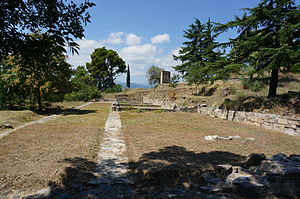
Scupi is an archaeological site located between Zajčev Rid and the Vardar River, several kilometers from the center of Skopje in North Macedonia. A Roman military camp was founded here in the second century BC on the site of an older Dardanian settlement. It became later Colonia Flavia Aelia Scupi and many veteran legionnaires were settled there. A Roman town was founded in the time of Domitian and Scupi became the chief center for romanizing Dardania. It was abandoned in AD 518 during interregnum between Anastasius I Dicorus and Justin I after an earthquake destroyed the city.
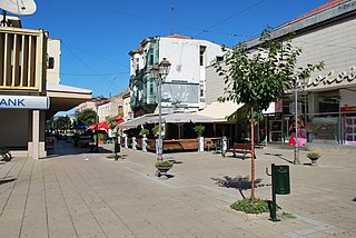
Gevgelija is a town with a population of 15,685 located in the very southeast of the North Macedonia along the banks of the Vardar River, situated at the country's main border with Greece (Bogorodica-Evzoni), the point which links the motorway from Skopje and three regional capitals, Belgrade, Zagreb, and Sofia with Thessaloniki in Greece. The town is the seat of Gevgelija municipality.

Negotino is a town in North Macedonia, the seat of the Negotino Municipality. Its population is about 13,000.

Lebane is a town and municipality located in Jablanica District of southern Serbia. According to the 2011 census, the town has a population of 10,062 inhabitants, while the municipality has 20,000 inhabitants.

Bogdanci is a small town in North Macedonia, close to the border with Greece. It is located at around 41°12′11″N22°34′32″E, and is the seat of Bogdanci Municipality.
Gradsko is a village located in the central part of North Macedonia. It is the seat of the Gradsko municipality. It is located very close to the main motorway which links Gevgelija on North Macedonia's border with Greece.

Altıntepe or Yerez is an Urartian fortress and temple archaeological site dating from the 9th to 7th century BCE. It is located on a small hill overlooking the Euphrates River in the Üzümlü district of Erzincan Province, Turkey.
Thymbra or Thymbre was a town in the Troad, near Troy. The second of the six gates of Troy was named after it, according to John Lydgate. The location is about five miles from present day Hissarlik, the site of the present archaeological excavations.

Leary Site, also known as 25-RH-1 or Leary-Kelly Site is an archaeological site near Rulo, Nebraska and the Big Nemaha River. The site now lies entirely on the reservation of the Iowa Tribe of Kansas and Nebraska. The area was once a village and burial site.
Dizə is a village and municipality in the Sharur District of Nakhchivan Autonomous Republic, Azerbaijan. It is located on the left bank of the river Arpachay (Arpa), on the Sharur plain. On the other side of the river is the village of Oglanqala.

The Shengavit Settlement is an archaeological site in present-day Yerevan, Armenia located on a hill south-east of Yerevan Lake. It was inhabited during a series of settlement phases from approximately 3000 BC cal to 2500 BC cal in the Kura Araxes (Shengavitian) Period of the Early Bronze Age and irregularly re-used in the Middle Bronze Age until 2200 BC cal. The town occupied an area of six hectares. It appears that Shengavit was a societal center for the areas surrounding the town due to its unusual size, evidence of surplus production of grains, and metallurgy, as well as its monumental 4 meter wide stone wall. Three smaller village sites of Moukhannat Tepe, Khorumbulagh, and Tairov have been identified and were located outside the walls of Shengavit. Its pottery makes it a type site of the Kura-Araxes or Early Transcaucasian Period and the Shengavitian culture area.
The Cloverdale archaeological site (23BN2) is an archaeological site located near present-day St. Joseph, Missouri. It is situated at the mouth of a small valley that opens into the Missouri River.

The Brick Church Mound and Village Site (40DV39) is a Mississippian culture archaeological site located in Nashville in Davidson County, Tennessee. It was excavated in the late nineteenth century by Frederic Ward Putnam. During excavations in the early 1970s, the site produced a unique cache of ceramic figurines very similar in style to Mississippian stone statuary which are now on display at the Frank H. McClung Museum. It was added to the National Register of Historic Places (NRHP) on May 7, 1973 as NRIS number 73001759 although this did not save the site from being almost totally destroyed by residential development.

Negorci is a village located 5 km north from the city of Gevgelija in North Macedonia.
Trapezitsa is a medieval stronghold located on a hill with the same name in Veliko Tarnovo in northern Bulgaria.
The Martz Rock Shelters was an archaeological site located near Myersdale, Somerset County, Pennsylvania, US, on the farm of Harry Martz. The Somerset County Archaeological Survey began its excavations on June 14, 1938, and was completed six days later. The site was located about 30 miles from Metropolitan Pittsburgh. The site was discovered around 1938 during the Works Projects Administration excavation project, necessary for the construction of state highway 219. It was located at a hill overlooking the Casselman River from which a shale ledge protruded about two hundred and fifty feet above the river. The opening of the caves faced south. The site was destroyed during the construction of the highway.

Sugh Ancient Mound, also known as the Ancient Site of Sugh, is located in the village of Amadalpur Dayalgarh, in the Yamunanagar district of Haryana, India. Suryamandir-Tirth in Amadalpur is nearby. Buddhist stupa here is identified with the Srughna.
The geology of North Macedonia includes the study of rocks dating to the Precambrian and a wide array of volcanic, sedimentary and metamorphic rocks formed in the last 539 million years.