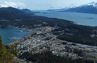
Haines is a census-designated place located in Haines Borough, Alaska, United States. It is in the northern part of the Alaska Panhandle, near Glacier Bay National Park and Preserve.

Hyder is a census-designated place in Prince of Wales-Hyder Census Area, Alaska, United States. The population was 87 at the 2010 census, down from 97 in 2000. Hyder is accessible by road only from Stewart, British Columbia, is popular with motorists wishing to visit Alaska without driving the length of the Alaska Highway, and is otherwise landlocked. It is the southernmost community in the state that can be reached via car. Hyder is Alaska's easternmost town.

The Alaska boundary dispute was a territorial dispute between the United States and the United Kingdom of Great Britain and Ireland, which then controlled Canada's foreign relations. It was resolved by arbitration in 1903. The dispute had existed between the Russian Empire and Britain since 1821, and was inherited by the United States as a consequence of the Alaska Purchase in 1867. The final resolution favored the American position, as Canada did not get an all-Canadian outlet from the Yukon gold fields to the sea. The disappointment and anger in Canada was directed less at the United States, and more at the British government for betraying Canadian interests in favor of healthier Anglo-American relations.
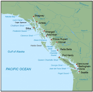
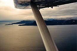
The Inside Passage is a coastal route for ships and boats along a network of passages which weave through the islands on the Pacific Northwest coast of the North American Fjordland. The route extends from southeastern Alaska in the United States, through western British Columbia in Canada, to northwestern Washington state in the United States. Ships using the route can avoid some of the bad weather in the open ocean and may visit some of the many isolated communities along the route. The Inside Passage is heavily travelled by cruise ships, freighters, tugs with tows, fishing craft, pleasure craft, and ships of the Alaska Marine Highway, BC Ferries, and Washington State Ferries systems. Coast Guard vessels of both Canada and the United States patrol and transit in the Passage.

The Dixon Entrance is a strait about 80 kilometers (50 mi) long and wide in the Pacific Ocean at the Canada–United States border, between the U.S. state of Alaska and the province of British Columbia in Canada. The Dixon Entrance is part of the Inside Passage shipping route. It forms part of the maritime boundary between the U.S. and Canada, although the location of that boundary here is disputed.

Glacier Bay Basin in southeastern Alaska, in the United States, encompasses the Glacier Bay and surrounding mountains and glaciers, which was first proclaimed a U.S. National Monument on February 25, 1925, and which was later, on December 2, 1980, enlarged and designated as the Glacier Bay National Park and Preserve under the Alaska National Interest Lands Conservation Act, covering an area of 3,283,000 acres. In 1986, UNESCO declared an area of 57,000 acres within a World Biosphere Reserve. This is the largest UNESCO protected biosphere in the world. In 1992, UNESCO included this area as a part of a World Heritage site, extending over an area of 24,300,000-acre (98,000 km2) which also included the Wrangell-St. Elias National Park, Kluane National Park (Canada) and Tatshenshini-Alsek Park (Canada). Part of the National Park is also designated a Wilderness area covering 2,658,000 acres.
Pearse Island is an island in western British Columbia, Canada, in the Portland Inlet, an inlet of the Pacific Ocean. The island was first charted in 1793 by George Vancouver during his 1791-95 expedition. It was named by George Henry Richards, captain of HMS Plumper, circa 1860, in honour of William Alfred Rombulow Pearse of the Royal Navy, who had been commander of HMS Alert.

Portland Canal is an arm of Portland Inlet, one of the principal inlets of the British Columbia Coast. It is approximately 114 km (71 mi) long. The Portland Canal forms part of the border between southeastern Alaska and British Columbia. The name of the entire inlet in the Nisga'a language is Kʼalii Xkʼalaan, with xkʼalaan meaning "at the back of (someplace)". The upper end of the inlet was home to the Tsetsaut, who after being decimated by war and disease were taken under the protection of the Laxsgiik (Eagle) chief of the Nisga'a, who holds the inlet's title in native law.

Stewart is a district municipality at the head of the Portland Canal in northwestern British Columbia, Canada, near the Alaskan panhandle. In 2011, its population was about 494.
Rivers Inlet is a fjord in the Central Coast region of the Canadian province of British Columbia, its entrance off Fitz Hugh Sound, about 125 km (78 mi) southwest of the community of Bella Coola and about 65 km (40 mi) north of the northern tip of Vancouver Island and the western entrance of the Queen Charlotte Strait.

The British Columbia Coast, popularly referred to as the BC Coast or simply the Coast, is a geographic region of the Canadian province of British Columbia. As the entire western continental coastline of Canada along the Pacific Ocean is in B.C., it is synonymous with being the West Coast of Canada.

Princess Royal Island is the largest island on the North Coast of British Columbia, Canada. It is located amongst the isolated inlets and islands east of Hecate Strait on the British Columbia Coast. At 2,251 square kilometres (869 sq mi), it is the fourth largest island in British Columbia. Princess Royal Island was named in 1788 by Captain Charles Duncan, after his sloop Princess Royal.

Porcher Island is an island in Hecate Strait, British Columbia, Canada, near the mouth of the Skeena River and southwest of the port city of Prince Rupert. The locality of Porcher Island is located near the island's northern tip at Humpback Bay, 54°05′11″N130°23′23″W. Stephens and Prescott Islands are located off its northwestern tip.

Portland Inlet is an inlet of the Pacific Ocean on the north coast of British Columbia, Canada, approximately 55 km (34 mi) north of Prince Rupert. It joins Chatham Sound opposite the Dixon Entrance. It is 4 km (2.5 mi) long and as much as 13 km (8.1 mi) wide. It drains the Portland Canal, Nass Bay, and Khutzeymateen Inlet, among others, and is the site of Pearse Island and Somerville Island. Other major sidewaters of the inlet are Observatory Inlet and its east arm, Alice Arm.

Calvert Island is an island on the coast of the Canadian province of British Columbia. It is located east of Queen Charlotte Sound in the Central Coast region, about 100 kilometres (62 mi) north of the town of Port Hardy, which is at the north end of Vancouver Island.
Tongass Passage is a strait on the Canada–United States border between Alaska and British Columbia, located on the southwest side of Wales Island. Wales Island, and Pearse Island, to its northeast, were claimed by the United States prior to the settlement of the Alaska boundary dispute in 1903. Prior to that time, numerous American-owned canneries lined its shores. Canadian claims to the islands were affirmed in the Alaska Boundary Settlement of 1903, in which Tongass Passage, Pearse Canal and the Portland Canal were defined as comprising "Portland Channel", a term first used in the Anglo-Russian Treaty of 1825 as part of the marine boundary between Russian America and British claims in the region, but which remained undefined until the boundary settlement.
Observatory Inlet is an inlet on the North Coast of British Columbia. It is a northward extension of Portland Inlet, other branches of which include the Portland Canal. The entrance of Observatory Inlet, from Portland Inlet, lies between Ramsden Point and Nass Point. Ramsden Point also marks, to the west, the entrance of Portland Canal. Observatory Inlet was named by George Vancouver in 1793, because he set up his observatory on the shore of the inlet, at Salmon Cove, in order to calibrate his chronometers. His two vessels, HMS Discovery and HMS Chatham, stayed in Salmon Cove from July 23 to August 17, 1793. During this time a boat surveying expedition under Vancouver himself explored Behm Canal. Vancouver also named three headlands at the entrance of Observatory Inlet: Maskelyne Point, for Nevil Maskelyne, the Astronomer Royal, Wales Point, for William Wales, the mathematical master who sailed with James Cook, and Ramsden Point, after the famed mathematical instrument-maker Jesse Ramsden.
Pearse Canal is a channel or strait forming part of the Canada–United States border at the southern end of the Alaska Panhandle and adjacent to the mouth of Portland Inlet. It is on the northwest side of Wales and Pearse Islands, which are in British Columbia, Canada, and forms part of the southwestern edge of Misty Fiords National Monument in Alaska, United States. The southwest entrance to the strait is between Phipp Point and Maie Point, both in Alaska.

Camosun was a steamship built in 1904 in Paisley, Scotland which served in British Columbia.