
The Nilgiris district is one of the 38 districts in the southern Indian state of Tamil Nadu. Nilgiri is the name given to a range of mountains spread across the borders among the states of Tamil Nadu, Karnataka and Kerala. The Nilgiri Hills are part of a larger mountain chain known as the Western Ghats. Their highest point is the mountain of Doddabetta, height 2,637 m. The district is contained mainly within the Nilgiri Mountains range. The administrative headquarters is located at Ooty. The district is bounded by Malappuram district of Kerala to the west, Coimbatore and Palakkad to the south, Erode to the east, and Chamarajnagar district of Karnataka and Wayanad district of Kerala to the north. As it is located at the junction of three states, namely, Tamil Nadu, Kerala, and Karnataka, significant Malayali and Kannadiga populations reside in the district. Nilgiris district is known for natural mines of Gold, which is also seen in the other parts of Nilgiri Biosphere Reserve extended in the neighbouring states of Karnataka and Kerala too.

Nandurbar district is an administrative district in the northwest corner of Maharashtra state in India. On 1 July 1998 Dhule was bifurcated as two separate districts now known as Dhule and Nandurbar. Nandurbar is a tribal-dominated district, The district headquarters are located at Nandurbar city. The district occupies an area of 5955 km2 and has a population of 1,648,295 of which 16.71% were urban.
Andal is a community development block that forms an administrative division in Durgapur subdivision of Paschim Bardhaman district in the Indian state of West Bengal.
Farmer suicides in India refers to the national catastrophe of farmers committing suicide since the 1970s, due to their inability to repay loans mostly taken from private landlords and banks. NCRB data shows that the incidence of farmer suicides has remained high in the 6 years between 2014 and 2020. Fifty-six hundred farmers committed suicide in 2014, and 5,500 farmers committed suicide in 2020. If the agricultural labourers are added to the 2020 number, the number of suicides rises to over 10,600.
Salanpur is a community development block that forms an administrative division in Asansol subdivision of Paschim Bardhaman district in the Indian state of West Bengal.
The economy of the state of Maharashtra is the largest in India. It is one of the most urbanised of Indian States.

Lavasa is a private, planned city built near Pune, India. It is stylistically based on the Italian town Portofino, with a street and several buildings bearing the name of that town.
Numbardar or Lambardar is a title in the Indian subcontinent which applies to powerful families of zamindars of the village revenue estate, a state-privileged status which is hereditary and has wide-ranging governmental powers share in it, the collaboration with the police for maintaining law and order in the village, and it comes with the associated social prestige. In contrast, the Zaildar who was the grand jagirdar and usually had the power over 40 to 100 villages. The Zail and Zaildar system of British Raj was abolished in 1952 in India but the lambardar system still continues in Pakistan and in some places in India.
Nandurbar Lok Sabha constituency is one of the 48 Lok Sabha (parliamentary) constituencies of Maharashtra state in western India. Presently, four of its Vidhan Sabha segments are located in Nandurbar district, while the other two segments are located in Dhule district.
The Economy of India under Company rule describes the economy of those regions that fell under Company rule in India during the years 1757 to 1858. The British East India Company began ruling parts of the Indian subcontinent beginning with the Battle of Plassey, which led to the conquest of Bengal Subah and the founding of the Bengal Presidency, before the Company expanded across most of the subcontinent up until the Indian Rebellion of 1857.
A Village accountant or Patwari, Talati or Lekhpal, is an administrative government position in rural areas of the Indian subcontinent. Introduced during the early 16th century, it was maintained by the British Raj. The official, as a representative of the state, is responsible for keeping land records, agricultural records and collecting taxes.
A Khasra Girdawari is a legal Revenue Department document used in India and Pakistan that specifies land and crop details. It is often used in conjunction with a shajra, which is a family tree of owner ;used for reference map of the village that administers the land described by the khasra girdawari. Khasras traditionally detail "all the fields and their areas, measurement, who owns and what cultivators he employs, what crops, what sort of soil, what trees are on the land.". In Indian Land record system, "Khatauni" is an account book, "Khasra girdawari" is a survey book and "Sajra" is the village map. At village level, patwari is appointed to update and maintain these land records.

A shujra or shujrah is a detailed village map that is used for legal and administrative purposes in India and Pakistan. A shujra maps out the village lands into land parcels and gives each parcel a unique number. The patwari maintains a record for each one of these parcels in documents called khasras.
Raniganj is a community development block that forms an administrative division in Asansol subdivision of Paschim Bardhaman district in the Indian state of West Bengal.

Kanksa is a community development block that forms an administrative division in Durgapur subdivision of Paschim Bardhaman district in the Indian state of West Bengal.

The Koli is an Indian caste found in Rajasthan, Himachal Pradesh, Gujarat, Maharashtra, Uttar Pradesh, Haryana, Karnataka, Odisha and Jammu and Kashmir states in India. Koli is an agriculturist caste of Gujarat but in coastal areas they also work as fishermen along with agriculture. In the beginning of 20th century, the Koli caste was recognised as a Criminal Tribe under Criminal Tribes Act by British Indian government because of their anti-social activities during World War I.

Digital India is a campaign launched by the Government of India to ensure that the Government's services are made available to citizens electronically through improved online infrastructure and by increasing Internet connectivity or making the country digitally empowered in the field of technology. The initiative includes plans to connect rural areas with high-speed internet networks. It consists of three core components: the development of secure and stable digital infrastructure, delivering government services digitally, and universal digital literacy.
Norangpura, near Chandgothi, is a village of less than 7,000 population, in Churu district of Rajasthan state of India. Clockwise, Rajgarh (Sadalpur) is 40 km, in north-east are Chandgothi 10 km and Hisar 110 km, in east are Pilani 20 km and Loharu 42 km and national capital Delhi 105 km, in south Jhunjhunu 31 km and state capital Jaipur 160 km, and in west Churu 65 km.
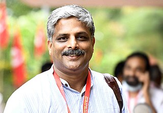
Dr. Vijoo Krishnan is an Indian peasant leader, writer on Agrarian Issues and the All India General Secretary of All India Kisan Sabha. He is a central committee member of Communist Party of India (Marxist). He is also part of the six-member central secretariat of CPI(M). He is one of the key organiser of Bhoomi Adhikar Andolan.