AN/FRD-10

Last updated

AN/FRD-10
Circularly Disposed Antenna Array (CDAA)
Overview of Facility 314, view facing northwest - U.S. Naval Base, Pearl Harbor, Naval Radio Station, AF-FRD-10 Circularly Disposed Antenna Array, Wahiawa, Honolulu County, HI HABS HI-522-B-1.tif
AN/FRD-10, Wahiawa, Hawaii
Country of originUnited States
Introduced1961
Type Circularly disposed antenna array (CDAA)
FrequencyLow Band 2-9 MHz [1]
High Band 9-32 MHz [1]
Inner Array Antenna radius393.5 feet (119.9 m) [1]
Inner Array Reflector radius366 feet (112 m) [1]
Outer Array Antenna radius436.75 feet (133.12 m)
431.75 feet (131.60 m) at 4 sites [1]
Outer Array Reflector radius423.5 feet (129.1 m) [1]
Range3,200 nautical miles (5,900 km)
Antenna Cost (1970)$800,000 to $900,000
($7.06 million today)
Electronics Cost (1970)$20 million
($157 million today)

The AN/FRD-10 is a United States Navy circularly disposed antenna array (CDAA), built at a number of locations during the cold war for high frequency radio direction finding (HF/DF) and signals intelligence. In the Joint Electronics Type Designation System, FRD stands for fixed ground, radio, direction finding. 14 sites were originally constructed as a part of the "Classic Bullseye" program. [2] [3] Two AN/FRD-10 systems were later installed in Canada. AN/FRD-10 systems were originally constructed in the early 1960s, but after the dissolution of the Soviet Union, the systems began to be shut down and demolished. The Naval Security Group operated and maintained the U.S. Navy AN/FRD-10 systems. The system had several nicknames including Fred-10 and Elephant or Dinosaur cages. [4] As of 2015, none of the US Navy AN/FRD-10 sites are extant, but the two Canadian sites remain in service.[ citation needed ] The AN/FLR-9 was a system with a similar design and function, but operated by the US Air Force and Army.

Contents

Bullseye

The program to install and operate the radio direction finding network was known as Bullseye, Clarinet Bullseye and Classic Bullseye at various points over its life cycle. [5] The word Classic was likely added later when permanently assigned "first words" were created for two-word nicknames. Classic was the word used to designate programs related to the Naval Security Group and Clarinet was used for programs related to the Chief of Naval Operations. [6] [7]

Classic Bullseye was also related to the Centerboard and Flaghoist programs. [8] Centerboard was a network for processing HF/DF information. [9] The security classification guide that covered all three programs was cancelled in January 2009. [10] [11] Later, the programs Unitary DF and Crosshair sought to unify the military's HF direction finding information into a single data collection network. [12] Crosshair, an HF/DF geolocation network, is apparently still in use c. 2015, employing small fixed or mobile HF/DF systems instead of large circular arrays. [13]

Development

The United States Naval Research Laboratory (NRL) led development of the technology that was used in the AN/FRD-10. Three developments were critical to the FRD-10, the ability to record portions of the frequency spectrum for future analysis, the Circularly Disposed Antenna Array (CDAA) and the computer control system that allowed rapid triangulation across multiple sites. [14] NRL funded research at a test site built in 1955 by the University of Illinois at the Bondville Road Field Station in Scott Township, Champaign County, Illinois, south of Bondville, Illinois. [15] The AN/FRD-10 antenna was a scaled-up version of the NRL prototype antenna array. [12]

Construction and cost

Plan view of a CDAA quadrant FRD-10 Plan View of CDAA.png
Plan view of a CDAA quadrant

In 1959, the Navy awarded a contract to ITT Federal Systems to construct a network of AN/FRD-10 systems. [16] The first AN/FRD-10 to be constructed was at NSGA Hanza in Okinawa, but future FRD-10 sites had different antenna dimensions. The High band reflector was reduced from 120 ft to 90 ft in later sites. Additionally, the outer high band antenna ring at Hanza was 311 feet (95 m) from the center with later sites being around 435 feet (133 m). [1] For the remaining sites, the outer antenna elements were spaced every 3 degrees around the circle and the outer reflector was 24.3 feet (7.4 m) tall. The inner antenna elements were spaced every 9 degrees and the inner reflector was 90 feet (27 m) tall. [1] One site was short lived. NSGA Marietta, Washington closed in 1972 and reverted to a Lummi reservation. [17] Marietta was the first FRD-10 site to shut down and operated less than 10 years.

Major components of the antenna array. FRD-10 Major Components CDAA.png
Major components of the antenna array.

The 1970 estimate to construct a CDAA was just under $900,000 ($7.06 million today) with electronics at the site estimated at $20 million ($157 million today). [1] The system had 120 high band antennas and 40 low band antennas which had to be positioned within +/- two minutes of arc and +/- 3 inches of their intended distance from the center of the array. 160 75 ohm coaxial transmission lines were used to carry signals from the antennas had to be electrically matched to within 3/4 of a degree at 10 MHz. This task was estimated at 300 to 400 man hours to complete. [1] There was also an extensive grounding system used at the FRD-10 sites. This included 360 ground radials made of 8 AWG wire, 150 feet (46 m) long, extending from the outer antenna ring. It also included a massive ground grid, made of 10 AWG wire bonded together to create a mesh with 2 feet (61 cm) squares. It was laid underground up to the radials in the area between the high and low antennas. [1]

Weather proved to be a challenge for the FRD-10 antennas. For example, the antenna at NSGA Winter Harbor had problems due to frost heaving the ground and shifting the reflector screens out of alignment. Digging up the affected poles and replacing them was costly and was estimated at $240,000 in the late 1970s. An alternative method was discovered that modified the poles to allow readjustment of the screen instead of the costly removal and replacement that had been done in the past. [18] The arrays were also vulnerable to high winds. Antenna arrays at Homestead, Florida and Sabana Seca, Puerto Rico were heavily damaged by hurricanes Andrew and Georges, respectively. [4]

Capabilities

25 ft high-band reflector screens on the left, behind the high-band monopole antenna at right. Detail of monopole antenna element (right) an d25' high-band reflector screen poles (left), view facing northeast - U.S. Naval Base, Pearl Harbor, Naval Radio Station, AF-FRD-10 HABS HI-522-B-11.tif
25 ft high-band reflector screens on the left, behind the high-band monopole antenna at right.

The AN/FRD-10 had an estimated range of 3,200 nautical miles (5,900 km) and was used to monitor and triangulate single or double hop high frequency (HF) signals between 2 and 32 MHz. Site locations were likely chosen based on HF hop distances for their intended surveillance targets. [2] The FRD-10 was designed to locate HF transmissions especially from submarines and was managed by the Naval Security Group. [2] The Navy also claimed over the years that the direction finding sites were used primarily for air and sea rescue operations [17] [19] and Naval communications in the case of the pair of FRD-10s at Sugar Grove Station. [20]

The FRD-10 used a goniometer to rapidly scan through all the antennas around the circle. This electronically "rotated" the antenna 360 degrees several times a second allowing fast and accurate direction finding. [16] This was needed because Soviet submarines began to use wide-band burst transmissions in the early 1960s to make themselves more difficult to pinpoint. Initially, these signals were too rapid for Bullseye's predecessor, Boresight, to locate, but the AN/FRD-10 was able to locate even very brief transmissions. [12]

Sites in the Classic Bullseye network were connected by communications links to facilitate "near instantaneous" triangulation of received signals if two or more sites received the same signal. Signals could also be recorded for later direction finding. The system was four times more accurate than the prior Navy AN/GRD-6 system with bearing accuracy better than 0.5 degrees. [2]

The Navy AN/FRD-10 was slightly smaller and had a narrower frequency range compared to the Air Force AN/FLR-9 system. [2] The FRD-10 had only 2 antenna rings, 870 feet (270 m) and 780 feet (240 m) diameters. [2] The Navy system was vertically instead of horizontally polarized. [2] The FRD-10 was also said to be closer to omnidirectional than to the FLR-9 due to complications added by having three sets of reflectors and with FLR-9 array looking inward rather than outward. On the FRD-10 the high band elements were on the outside, vs inside. [2]

Smaller AX-16 Pusher antenna arrays were developed with about half the diameter of the AN/FRD-10 and were used at sites that required a smaller footprint, like Diego Garcia and other sites in the United Kingdom. [12] The pusher systems were found to have lower performance, but not primarily due to the reduced antenna size. Most of the excess signal loss and higher noise floor was attributed to problems with the RF distribution network and higher transmission line losses due to the RG-8 coaxial cable that the pusher systems used. [21]

Former locations of FRD-10 sites

Atlantic

FRD-10 sites in the Atlantic AN FRD-10 HFDF atlantic map.png
FRD-10 sites in the Atlantic
No.Site NameLocationMap linkFate
1NSGA Galeta Island Galeta Island, Panama 9°24′09″N79°52′20″W / 9.402409°N 79.872279°W / 9.402409; -79.872279 Shut down 1995, abandoned in place. [4]
2NSGA Sabana Seca Toa Baja, Puerto Rico 18°27′16″N66°13′36″W / 18.454368°N 66.226646°W / 18.454368; -66.226646 Damaged by Hurricane Georges in 1998, demolished 1999. [4]
3NSGA Homestead Homestead, Florida 25°22′21″N80°25′24″W / 25.372582°N 80.423358°W / 25.372582; -80.423358 Damaged by Hurricane Andrew in 1992, later demolished. [4]
4NSGA Northwest Chesapeake, Virginia 36°32′56″N76°15′31″W / 36.548900°N 76.258646°W / 36.548900; -76.258646 Shut down 2001, demolished. [4]
5 NSGA Winter Harbor Winter Harbor, Maine 44°24′04″N67°59′28″W / 44.401239°N 67.991033°W / 44.401239; -67.991033 Shut down 1998, demolished 2001. [4]
6 CFB Gander Gander, Newfoundland, Canada 48°57′03″N54°31′29″W / 48.950718°N 54.524717°W / 48.950718; -54.524717 Operational.[ citation needed ] [22] [23]
7NSGA Edzell RAF Edzell, Edzell, Scotland 56°48′33″N2°36′20″W / 56.809282°N 2.605551°W / 56.809282; -2.605551 Shut down 1997, demolished later. [4]
8NSGA Rota NS Rota, Rota, Cádiz, Spain 36°39′24″N6°21′54″W / 36.656563°N 6.364955°W / 36.656563; -6.364955 Shut down 1993, demolished 2005. [4]

Pacific

FRD-10 sites in the Pacific AN FRD-10 HFDF pacific map.png
FRD-10 sites in the Pacific
No.Site NameLocationMap linkFate
1 NCTS Guam (NCTS Finegayan) Dededo, Guam 13°35′37″N144°51′09″E / 13.593609°N 144.852547°E / 13.593609; 144.852547 Shut down 1999, demolished 2000s. [4]
2NSGA HanzaOkinawa 26°24′01″N127°43′48″E / 26.400327°N 127.729883°E / 26.400327; 127.729883 Shut down 1997, demolished 2007. [4]
3NSGA Adak Adak, Alaska 51°56′33″N176°36′02″W / 51.942637°N 176.600438°W / 51.942637; -176.600438 Shut down 1994, later demolished. [4]
4 CFS Masset Masset, British Columbia, Canada 54°01′44″N132°03′55″W / 54.02881°N 132.065363°W / 54.02881; -132.065363 Operational as of 2008, operated remotely from CFS Leitrim, Ontario. [4] [ citation needed ]
5NSGA Marietta Marietta-Alderwood, Washington 48°47′39″N122°39′16″W / 48.794226°N 122.654465°W / 48.794226; -122.654465 Closed 1972, first Bullseye site closed. [4]
6 NSGA Skaggs Island Sonoma County, California 38°10′08″N122°22′23″W / 38.168968°N 122.373061°W / 38.168968; -122.373061 Shut down 1993, later demolished. [4]
7 NSGA Imperial Beach Imperial Beach, California 32°35′36″N117°07′45″W / 32.593468°N 117.129064°W / 32.593468; -117.129064 Shut down 1999, demolished 2015. [4]
8NCTAMS Wahiawa Wahiawa, Hawaii 21°31′20″N158°00′41″W / 21.522321°N 158.011329°W / 21.522321; -158.011329 Shut down 1998, demolished 2005. [4]

Other

See also

Related Research Articles

<span class="mw-page-title-main">Signals intelligence</span> Intelligence-gathering by interception of signals

Signals intelligence (SIGINT) is the act and field of intelligence-gathering by interception of signals, whether communications between people or from electronic signals not directly used in communication. Signals intelligence is a subset of intelligence collection management. As classified and sensitive information is usually encrypted, signals intelligence may necessarily involve cryptanalysis. Traffic analysis—the study of who is signaling to whom and in what quantity—is also used to integrate information, and it may complement cryptanalysis.

<span class="mw-page-title-main">RAF Chicksands</span>

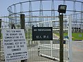
Royal Air Force Chicksands or more simply RAF Chicksands, was a Royal Air Force station located 7.7 miles south east of Bedford, Bedfordshire and 11.6 miles north east of Luton, Bedfordshire. It closed in 1997 when responsibility for the camp was taken over by the British Army Intelligence Corps. Near the town of Shefford it is named after Chicksands Priory, a 12th-century Gilbertine monastery located within the perimeter of the camp.

<span class="mw-page-title-main">Direction finding</span> Measurement of the direction from which a received signal was transmitted

Direction finding (DF), or radio direction finding (RDF), is the use of radio waves to determine the direction to a radio source. The source may be a cooperating radio transmitter or may be an inadvertant source, a naturally-occurring radio source, or an illicit or enemy system. Radio direction finding differs from radar in that only the direction is determined by any one receiver; a radar system usually also gives a distance to the object of interest, as well as direction. By triangulation, the location of a radio source can be determined by measuring its direction from two or more locations. Radio direction finding is used in radio navigation for ships and aircraft, to locate emergency transmitters for search and rescue, for tracking wildlife, and to locate illegal or interfering transmitters. During the Second World War, radio direction finding was used by both sides to locate and direct aircraft, surface ships, and submarines.

<span class="mw-page-title-main">High-frequency direction finding</span> Electronic equipment for finding radio sources

High-frequency direction finding, usually known by its abbreviation HF/DF or nickname huff-duff, is a type of radio direction finder (RDF) introduced in World War II. High frequency (HF) refers to a radio band that can effectively communicate over long distances; for example, between U-boats and their land-based headquarters. HF/DF was primarily used to catch enemy radios while they transmitted, although it was also used to locate friendly aircraft as a navigation aid. The basic technique remains in use as one of the fundamental disciplines of signals intelligence, although typically incorporated into a larger suite of radio systems and radars instead of being a stand-alone system.

<span class="mw-page-title-main">Circularly disposed antenna array</span> Circular antenna for radio direction finding

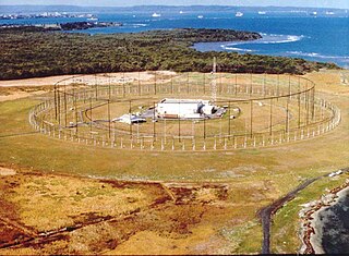
A circularly disposed antenna array (CDAA), sometimes referred to as a circularly disposed dipole array (CDDA) or a wullenweber, is a large circular antenna array used for radio direction finding. They are used by military and government agencies to triangulate radio signals for radio navigation, intelligence gathering, search and rescue, and enforcement of broadcasting laws. Because their huge circular reflecting screens looks like circular fences, some antennas have been colloquially referred to as "elephant cages". The term "wullenwever" was the World War II German cover term used to identify their secret CDAA research and development program; its name is unrelated to any person involved in the program.

<span class="mw-page-title-main">CFS Leitrim</span>

Canadian Forces Station Leitrim, also referred to as CFS Leitrim, is a Canadian Forces Station located in the neighbourhood of Leitrim in Ottawa, Ontario. It is concerned with the interception, decrypting and processing of communication for the Communications Security Establishment and the Canadian Forces, and forms part of the ECHELON system.

<span class="mw-page-title-main">Galeta Island (Panama)</span>

Galeta Island is an island located on the Atlantic side of the Republic of Panama, just east of the city of Colón, Panama.

San Vito dei Normanni Air Station was a United States Air Force facility located 7 miles (11 km) west of Brindisi, Apulia, between the port of Brindisi and the town of San Vito dei Normanni, Italy.

<span class="mw-page-title-main">Silver Strand Training Complex</span>

Silver Strand Training Complex South (SSTC-S), formerly known as the Naval Radio Receiving Facility (NRRF), is the premier training facility for U.S. Special Operations Forces. Located between Imperial Beach and Silver Strand State Beach near San Diego in southern California, USA, this facility was known by locals as the "elephant cage" which is a nickname for the large Wullenweber direction finder antenna. The antenna was used to provide direction finding, primary communication links for U.S. Navy submarines. The antenna was finally dismantled in 2015, even though it was scheduled to be removed in fiscal year 2007. Presently the area is part of Naval Base Coronado and commanded by that base's Commanding Officer. While just north of Imperial Beach, it is within the city limits of Coronado.

<span class="mw-page-title-main">Naval Security Group Activity, Winter Harbor</span>

Naval Security Group Activity, Winter Harbor was a radio station of the United States Navy that operated from 1935 to 2002.

<span class="mw-page-title-main">Wacław Struszyński</span> Polish electronic engineer (1904–1980)

Wacław Struszyński was a Polish electronics engineer who made a vital contribution to the defeat of U-boats in the Battle of the Atlantic. He designed an exceptional radio antenna which enabled effective high frequency (HF) radio direction finding systems to be installed on Royal Navy convoy escort ships. Such direction finding systems were referred to as HF/DF or Huff-Duff, and enabled the bearings of U-boats to be determined when the U-boats made high frequency radio transmissions.

Gablingen Kaserne is a former military facility in Gablingen near Augsburg, Germany, which was closed in 1998. Its primary use was signals intelligence collection during the Cold War.

Skaggs Island Naval Communication Station is a former United States Navy installation located near California State Route 37 between Novato and Vallejo, California. It was a secretive, secure, and self-contained naval base, engaged in a number of communications and intelligence gathering functions for the Navy and other federal intelligence organizations. The 3,310-acre (13.4 km2) site was purchased by the Navy in 1941, and closed in 1993. The antennas continued to be used for some time after that, but by 2013 they were removed along with all of the remaining buildings.

<span class="mw-page-title-main">United States Air Force Security Service</span> Former signals intelligence service of the US Air Force

Initially established as the Air Force (USAF) Security Group in June, 1948, the USAF Security Service (USAFSS) was activated as a major command on 20 October 1948.

<span class="mw-page-title-main">AN/FLR-9</span> United States circularly disposed antenna array

The AN/FLR-9 is a type of very large circularly disposed antenna array, built at eight locations during the cold war for HF/DF direction finding of high priority targets. The worldwide network, known collectively as "Iron Horse", could locate HF communications almost anywhere on Earth. Because of the exceptionally large size of its outer reflecting screen, the FLR-9 was commonly referred to by the nickname "Elephant Cage." Constructed in the early to mid 1960s, in May 2016 the last operational FLR-9 at Joint Base Elmendorf-Richardson in Alaska was decommissioned. It can be confused with the US Navy's AN/FRD-10, which also used a circularly disposed antenna array.

<span class="mw-page-title-main">CFS Masset</span> Place in British Columbia, Canada

Canadian Forces Station Masset was a Canadian Forces station and signals intercept facility located near Masset, British Columbia. The station was officially stood-down on 1 April 1997 and re-established as Canadian Forces Station Leitrim Detachment Masset.

<span class="mw-page-title-main">Curtain array</span> Class of large multielement directional wire radio transmitting antennas

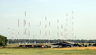
Curtain arrays are a class of large multielement directional radio transmitting wire antennas, used in the shortwave radio bands. They are a type of reflective array antenna, consisting of multiple wire dipole antennas, suspended in a vertical plane, often in front of a "curtain" reflector made of a flat vertical screen of many long parallel wires. These are suspended by support wires strung between pairs of tall steel towers, up to 90 m high. They are used for long-distance skywave transmission; they transmit a beam of radio waves at a shallow angle into the sky just above the horizon, which is reflected by the ionosphere back to Earth beyond the horizon. Curtain antennas are mostly used by international short wave radio stations to broadcast to large areas at transcontinental distances.

Maxwell K. Goldstein was a first generation Jewish-American scientist and engineer who was instrumental in the development and deployment of high-frequency direction finding by the United States Navy during the Second World War. High-frequency direction finding played a significant role in the Allies efforts to counter the threat of German U-boats (submarines) during the Battle of the Atlantic. This success helped ensure the continued flow of equipment and supplies from the United States to Britain and to European battlefields, which was a critical factor in the ultimate Allied victory. Following World War II, Goldstein founded Balco Research Laboratory, which specialized in high resistance capacitors used in numerous military, civilian, and NASA projects.

<span class="mw-page-title-main">Naval Computer and Telecommunications Station Guam</span> Military unit

Naval Computer and Telecommunications Station Guam is a United States Navy communications facility on the U.S. territory of Guam. It is located on the Naval Base Guam North Finegayan Telecommunications Site along Guam Highway 3 in Dededo, on the northwest coast of the island.

Project Boresight was a United States program that built radio-location systems to find the position of Russian submarines that were using burst communications. It was created as a top-secret program.

References

  1. 1 2 3 4 5 6 7 8 9 10 11 "Maintenance Manual for Antenna Groups OA-3967(XN-1)/FRD-10(V) and OA-3967/FRD-10(V) (15 MB)" (PDF). navy-radio.com. 1972. Retrieved 2 August 2015.
  2. 1 2 3 4 5 6 7 8 Ruzicka, Dan (May 2007). HABS No. HI-522-B (PDF) (Report). Historic American Buildings Survey. Archived from the original (PDF) on 4 March 2016. Retrieved 2 August 2015.
  3. "AN/FRD-10 CLASSIC BULLSEYE". fas.org. Retrieved 2 August 2015.
  4. 1 2 3 4 5 6 7 8 9 10 11 12 13 14 15 16 17 18 Morris, Michael R. (27 May 2008). "Wullenweber Antenna Arrays". Navy CT History at navycthistory.com. Retrieved 3 July 2023.
  5. Proc, Jerry (3 February 2015). "CFS Masset" . Retrieved 4 August 2015.
  6. Parsch, Andreas (2005). "Code Names for U.S. Military Projects and Operations" . Retrieved 4 August 2015.
  7. "OPNAVINST 5511.37D" (PDF). Chief of Naval Operations via fas.org. Retrieved 5 August 2015.
  8. "Declassified US Government Internal Documents on the Central Intelligence Agency (CIA) #255". Archive.org. Retrieved 2 August 2015.
  9. "Centerboard". fas.org. Archived from the original on 25 December 2015. Retrieved 2 August 2015.
  10. Cancelled DON SCGs Report (PDF) (Report). Secretary of the Navy. Archived from the original (PDF) on 24 September 2015. Retrieved 2 August 2015.
  11. OPNAVINST 5513.4E (PDF) (Report). Chief of Naval Operations, via fas.org. Retrieved 2 August 2015.
  12. 1 2 3 4 Friedman, Norman (2006). The Naval Institute Guide to World Naval Weapon Systems. Naval Institute Press. p. 20. ISBN   978-1-55750-262-9.
  13. Richelson, Jeffrey T (2015). The U.S. Intelligence Community. Westview Press. p. 243. ISBN   978-0-8133-4919-0 . Retrieved 2 August 2015.
  14. "75th Anniversary Awards for Innovation" (PDF). Naval Research Laboratory. 1998. p. 28. Archived from the original (PDF) on 3 August 2015. Retrieved 2 August 2015.
  15. "Wullenweber and the books it made happen" (PDF). faculty.ece.illinois.edu. Retrieved 2 August 2015.
  16. 1 2 "The CDAA Antenna and the Wullenweber". Military Products Digest. September 2014. Retrieved 5 August 2015.[ permanent dead link ]
  17. 1 2 "Navy plans to close unit". Spokane Daily Chronicle. AP. 5 November 1971. Retrieved 5 August 2015.
  18. Gordon, Michael (27 March 1981). "Man Gets $1,175 for $240,000 Idea". Bangor Daily News.
  19. "Winter Harbor Naval Base Receives Orders until 2000". Bangor Daily News. 12 May 1995.
  20. Herman, Steven (10 June 1987). "National Security Agency has big, secret ears". Schenectady Gazette. AP.
  21. "AN/FRD-10 vs AN/AX-16 Pusher" (PDF). Archived (PDF) from the original on 24 September 2015. Retrieved 2 August 2015.
  22. "CFS Leitrim Detachment - General Information | 9 Wing Lodger Units | 9 Wing Gander | RCAF | DND/CF". Archived from the original on 22 July 2012. Retrieved 16 September 2011.
  23. "Gander SIGNIT Station". (As of Feb 2007 website update) Today, the Gander SIGINT facility is maintained by a handful of dedicated on-site personnel.
  24. Google earth imagery dated 31 Dec 2002