In physical geography, a steppe is an ecoregion characterized by grassland plains without closed forests except near rivers and lakes. Steppe biomes may include:
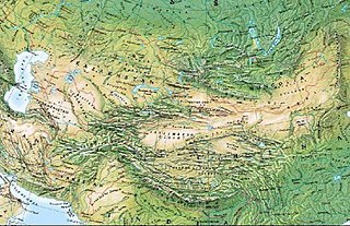
The Mountains of Central Asia are a biodiversity hot spot designated by Conservation International which covers several montane and alpine ecoregions of Central Asia, including those of the Pamir and Tian Shan ranges, and extending across portions of Afghanistan, China, Kazakhstan, Kyrgyzstan, Tajikistan, Uzbekistan and the Karakoram range in China, Pakistan and India. The Karakoram range is also famously known for Karakoram Anomaly that relates to the anomalous growth of glaciers in the central Karakoram that is in contrast with melting glaciers in other mountainous ranges of Himalayas and other parts of the world due to the effects of climate change.
The wildlife of Turkmenistan is the flora and fauna of Turkmenistan, and the natural habitats in which they live. Turkmenistan is a country in Central Asia to the east of the Caspian Sea. Two thirds of the country is hot dry plains and desert, and the rest is more mountainous. Very little rain falls in summer and the chief precipitation occurs in the southern part of the country in the winter and spring. The Caspian coast has milder winters.

Sayram-Ugam National Park, also Sairam-Ugam, is a mountainous region of the Western Tian Shan Mountains, on the border with Uzbekistan. Ugam-Chatkal National Park of Uzbekistan is across the border, and Aksu-Zhabagly Nature Reserve of Kazakhstan is directly to the northeast along the border. The area has high levels of species diversity, covering floral communities from steppe to high altitude zones. It is particularly known for stands of juniper forests, and stands of fruit and nut trees. Sayram-Ugam is located in Kazygurt District, Tole Bi District and Tulkibas District of South Kazakhstan Region. The park boundary is 30 kilometres (19 mi) southeast of the regional city of Shymkent, and 50 km northeast of the Uzbekh capital of Tashkent.

Zhongar-Alatau National Park, also Jungar Alatau, or Dzungurian Alatau, was created in 2010 to protect the unique ecology of the Dzungarian Alatau, an isolated, glaciated mountain range in Kazakhstan, on the southeastern border with China. One stated reason for creating the park is to protect forests of wild fruit trees, including apricots, barberry, cherries, and currants. Approximately 1% of the land area of the park is forested with Sievers Apple trees, which are the progenitors of all cultured apple varieties in the world. The park is 300 km long (west-to-east), and spreads across Aksu District, Sarkand District and Alakol District of Almaty Region, 300 km northeast of the regional city of Almaty.
The Kazakh forest steppe ecoregion is a long thin strip of transition zone between the forested taiga of Siberian Russia, and the Kazakh steppe to the south. The ecoregion stretches over 2,000 km from the southern Ural mountains in the west to the foothills of Altai mountains in the east, yet averages only 200 km from south to north across its length. Because the region is farther inland than European forest steppe, and some 300 to 500 km farther north, the climate is more continental and with less precipitation the tree cover more sparse. The ecoregion is in the Temperate grasslands, savannas, and shrublands biome, and the Palearctic realm, with a Humid Continental climate. It covers 420,614 km2 (162,400 sq mi).
The Tian Shan montane conifer forests ecoregion covers the "forest belt" of the Tian Shan mountains - generally the north-facing slopes that get enough moisture, and are warm enough, for trees to grow. This conifer belt is found mostly between 1,500 and 2,700 meters.

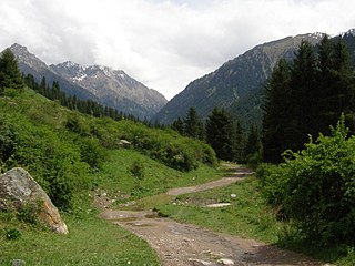
The Tian Shan montane steppe and meadows ecoregion covers a 2,000 km long stretch of grasslands of the isolated Tian Shan mountains of Central Asia. It is characterized by high-altitude flat and rolling grasslands.

The Tian Shan foothill arid steppe ecoregion covers the northern and western approaches to the Tian Shan mountains, centered on Lake Issyk-Kul in Kyrgyzstan. This region receives more moisture from Central Asia, thereby supporting more vegetation and diversity of plant and animal species than the deserts to the south.

The Pamir alpine desert and tundra ecoregion covers the high plateau of the Pamir Mountains, at the central meeting of the great mountain ranges of Central Asia: Himalaya, Karakoram, Hindu Kush, Kunlun, and Tian Shan. It is a region of relatively high biodiversity due to its central location and high elevation differentials, but it also acts as a barrier between the climate and habitats of north and south Asia.

The Yarlung Tsangpo arid steppe ecoregion covers the river valley of the Yarlung Tsangpo River on the southern edge of Tibet. The river runs parallel to the northern borders of Nepal, Bhutan and India, between the Himalayas to the south and the Tibet Plateau to the north. The river valleys are the most populated areas of Tibet, putting pressure on wildlife. The area ranges from cold desert in the west to steppe shrub land in the east; the few trees are in the lowest river valleys to the east.

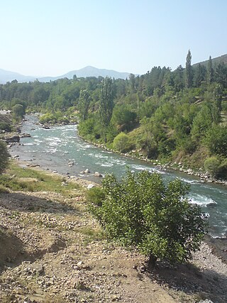
The Central Asian riparian woodlands ecoregion is spread out across the deserts and plains of central Asia between the Aral Sea and the mountains 2,000 kilometres (1,200 mi) to the east. The long narrow components of the ecoregion follow the large rivers fed by snowmelt, and provide critical habitat for migratory birds as they travel through the arid region. The vegetation is referred to as tugai, characterized by low tangles of trees and brush along the edges of the rivers and associated wetlands, and fed by groundwater instead of precipitation.

The Central Asian southern desert ecoregion is an arid but ecologically active region between the east coast of the Caspian Sea and steppes at the base of the mountains of central Asia. Most of Turkmenistan and eastern Uzbekistan is in this ecoregion. The winters are milder than in the cold desert to the north, and a large number of endemic species have adapted to living in the particular climate and soil of the region. As with sandy deserts in general, the region is notable for high numbers of endemic species of reptiles and insects.

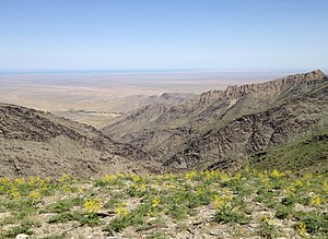
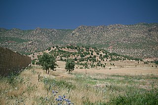
The Kopet Dag semi-desert ecoregion is a small ecoregion that crosses the border of southwestern Turkmenistan into northeastern Iran. It covers a transition zone between the deserts to the north and west, and the foothill steppes and woodlands in the higher Kopet Dag mountains to the east and the Alborz Mountains to the south. The terrain is mostly barren semi-desert and widespread 'takir', a type of seasonal salt flat or dried clay deposit in an interdune depression.

The Kopet Dag woodlands and forest steppe ecoregion coincides with the Kopet Dag mountains, straddling the southern border of Turkmenistan and the northeastern border of Iran. The region is one of high biodiversity, as it includes a full range of altitude zones, and variety of habitats included juniper-wooded slopes, montane grasslands, and tugay.
The Gissaro-Alai open woodlands ecoregion covers the western foothills winding around two western offshoots of the Tian Shan Mountains in western Tajikistan, and parts of eastern Uzbekistan and western Kyrgyzstan, in Central Asia. The woodlands are typically of Juniper trees and shrubs, fitting the altitude zone situated between the desert valley floor, and the tree line, above which the mountain ridges are glaciated and barren.
The Middle East steppe ecoregion stretches in an arc from southern Jordan across Syria and Iraq to the western border of Iran. The upper plains of the Tigris and Euphrates Rivers dominate most of the ecoregion. The terrain is mostly open shrub steppe. The climate is arid. Evidence is that this region was once more of a forest-steppe, but centuries of overgrazing and gathering firewood have reduced tree and grass cover to small areas and along the riverine corridors. Despite the degraded condition of the steppe environment, the ecoregion is important for water birds as the rivers and reservoirs provide habitat in the arid region.

The Kuh Rud and Eastern Iran montane woodlands ecoregion covers hills and mountains in central and eastern Iran. The habitat is wetter and cooler than the surrounding desert of the Iranian Plateau, supporting the vulnerable goitered gazelle and small populations of the cheetah. The ecoregion is under conservation threat from overgrazing and conversion of steep slopes to cultivation.