Related Research Articles

Cape Town is the legislative capital of South Africa. It is the country's oldest city and the seat of the Parliament of South Africa. It is the country's second-largest city, after Johannesburg, and the largest in the Western Cape. The city is part of the City of Cape Town metropolitan municipality.

Cape Agulhas is a rocky headland in Western Cape, South Africa. It is the geographic southern tip of Africa and the beginning of the traditional dividing line between the Atlantic and Indian Oceans according to the International Hydrographic Organization. It is approximately half a degree of latitude, or 55 kilometres (34 mi), further south than the Cape of Good Hope.

East London is a city on the southeastern coast of South Africa, in the Buffalo City Metropolitan Municipality, Eastern Cape Province. The city lies on the Indian Ocean coast, largely between the Buffalo River and the Nahoon River, and hosts the country's only river port. As of 2011, East London had a population of over 267,000 with over 755,000 in the surrounding metropolitan area.

The Western Cape is a province of South Africa, situated on the south-western coast of the country. It is the fourth largest of the nine provinces with an area of 129,449 square kilometres (49,981 sq mi), and the third most populous, with an estimated 7 million inhabitants in 2020. About two-thirds of these inhabitants live in the metropolitan area of Cape Town, which is also the provincial capital. The Western Cape was created in 1994 from part of the former Cape Province. The two largest cities are Cape Town and George.

Overberg is a region in South Africa to the east of Cape Town beyond the Hottentots-Holland mountains. It lies along the Western Cape Province's south coast between the Cape Peninsula and the region known as the Garden Route in the east. The boundaries of the Overberg are the Hottentots-Holland mountains in the West; the Riviersonderend Mountains, part of the Cape Fold Belt, in the North; the Atlantic and Indian Oceans in the South and the Breede River in the East.

Overstrand Municipality is a local municipality in the Western Cape province of South Africa. It is located along the Atlantic coast between Cape Town and Cape Agulhas, within the Overberg District Municipality. The principal towns in the municipality are Hermanus, Gansbaai and Kleinmond. As of 2011, it had a population of 80,432.

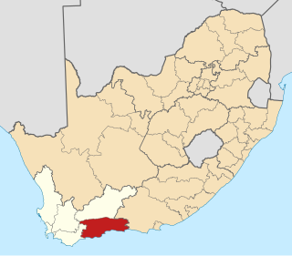
Cape Agulhas Municipality is a municipality located in the Western Cape province of South Africa. As of 2011, it had a population of 33,038. Its municipality code is WC033. It is named after Cape Agulhas, the southernmost point of Africa. The largest town is Bredasdorp, which is the seat of the municipal headquarters. It also includes the villages of Napier, Struisbaai, Elim, Arniston and L'Agulhas, and the De Hoop Nature Reserve.

Swellendam Municipality is a local municipality located within the Overberg District Municipality, in the Western Cape province of South Africa. As of 2011, it had a population of 35,916. Its municipality code is WC034.

Theewaterskloof Municipality is a local municipality located within the Overberg District Municipality, in the Western Cape province of South Africa. As of 2007, the population was 108,790. Its municipality code is WC031. The enormous Theewaterskloof Dam, which provides water for Cape Town and the surrounding areas, is located in this municipality.

The Overberg District Municipality is a district municipality that governs the Overberg region in the Western Cape province of South Africa. It is divided into four local municipalities and includes the major towns of Grabouw, Caledon, Hermanus, Bredasdorp and Swellendam. The municipal area covers 12,241 square kilometres (4,726 sq mi) and had in 2007 an estimated population of 212,787 people in 60,056 households.

Gqeberha, previously named Port Elizabeth, and colloquially referred to as P.E., is a major seaport and the most populous city in the Eastern Cape province of South Africa. It is the seat of the Nelson Mandela Bay Metropolitan Municipality, South Africa's second-smallest metropolitan municipality by area. It is the sixth-most populous city in South Africa and is the cultural, economic and financial hub of the Eastern Cape.
The City of Ekurhuleni Metropolitan Municipality is a metropolitan municipality that forms the local government of the East Rand region of Gauteng, a large suburban region east of Johannesburg. Ekurhuleni means "place of peace" in XiTsonga. Ekurhuleni is one of the five districts of Gauteng and one of the eight metropolitan municipalities of South Africa. The seat of Ekurhuleni is Germiston and the most spoken language is Zulu at 28.6%. The city is home to South Africa's busiest airport, OR Tambo International Airport, which is in the Kempton Park area of Ekurhuleni.

The City of Cape Town is the local government of Cape Town and surrounding areas. As of the 2016 community survey, it had a population of 4,005,016.
The Garden Route District Municipality, formerly known as the Eden District Municipality, is a district municipality located in the Western Cape province of South Africa. Its municipality code is DC4.
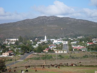
Bredasdorp is a town in the Southern Overberg region of the Western Cape, South Africa, and the main economic and service hub of that region. It lies on the northern edge of the Agulhas Plain, about 160 kilometres (100 mi) south-east of Cape Town and 35 kilometres (22 mi) north of Cape Agulhas, the southernmost tip of Africa.
The Cape Independence Party (CAPEXIT), previously called the Cape Party, is a political party in South Africa which seeks to use all constitutional and legal means to bring about Cape independence, which includes the entire Western Cape, Northern Cape, six municipalities in the Eastern Cape, and one municipality in the Free State. The area includes all municipalities in those provinces with an Afrikaans-speaking majority. In 2009, it had a membership of approximately 1,000 people across South Africa which has grown to over 10,000 by 2017. The party currently holds two seats on the Cape Town City Council.

Air Force Base Overberg is an airbase of the South African Air Force at Bredasdorp on the Overberg district of the Western Cape province and is the host of the 525 squadron and the Test Flight and Development Centre. It is placed under command of the Air Office in Pretoria, Gauteng.

Renosterveld is a term used for one of the major plant communities and vegetation types of the Cape Floristic Region which is located in southwestern and southeastern South Africa, in southernmost Africa. It is an ecoregion of the Mediterranean forests, woodlands, and scrub biome.
Stanford is a small riverside village in Overberg District Municipality in the Western Cape province of South Africa. Located 16 km east of Hermanus and 22 km north-east of Gansbaai.
Chris Hunsinger is a South African politician, a Member of the South African Parliament since 2014, Caucus Whip and Treasurer with the Democratic Alliance. He was appointed by the then Leader of the Opposition Mmusi Maimane on 5 June 2019 and retained by the current Leader of the Opposition John Steenhuisen in October 2019 and again in December 2020, as The Shadow Minister of Transport. Hunsinger was re-elected to Parliament on 6 June 2019. He speaks and writes about issues related to consumer and commodity needs in transport, including safety, planning, finance and management with South African road, rail, maritime, and aviation service providers.
References
- ↑ "Andrew's Field - South Africa". World Airport Codes. Retrieved 10 October 2021.
- ↑ "Andrew's Field Airport, Overberg District Municipality, Western Cape, South Africa". za.geoview.info. Retrieved 10 October 2021.
- ↑ "Codes of Airport of Andrews Field in Andrews Field, South Africa (ZA) | ICAO, IATA codes, location of airports of Codes of Airport of Andrews Field in Andrews Field, South Africa (ZA) | latitude, longitude airports of Codes of Airport of Andrews Field in Andrews Field, South Africa (ZA) | coordinates of airports of Codes of Airport of Andrews Field in Andrews Field, South Africa (ZA) | International codes and coordinates of all airports in the world | International codes and coordinates of all airports in Codes of Airport of Andrews Field in Andrews Field, South Africa (ZA)". airportsbase.org. Retrieved 10 October 2021.
| | This article about an airport in South Africa is a stub. You can help Wikipedia by expanding it. |