Bessarabia is a historical region in Eastern Europe, bounded by the Dniester river on the east and the Prut river on the west. About two thirds of Bessarabia lies within modern-day Moldova, with the Budjak region covering the southern coastal region and part of the Ukrainian Chernivtsi Oblast covering a small area in the north.

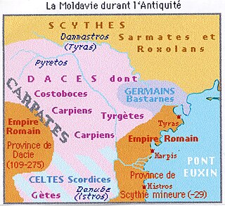
Dacia was the land inhabited by the Dacians, its core in Transylvania, stretching to the Danube in the south, the Black Sea in the east, and the Tisza in the west. The Carpathian Mountains were located in the middle of Dacia. It thus roughly corresponds to the present-day countries of Romania, as well as parts of Moldova, Bulgaria, Serbia, Hungary, Slovakia, and Ukraine.
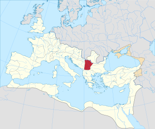
Moesia was an ancient region and later Roman province situated in the Balkans south of the Danube River. Moesian Province was first administered by governor of Noricum as 'Civitates of Moesia and Triballia'. It included most of the territory of modern eastern Serbia, Kosovo, north-eastern Albania, northern parts of North Macedonia, Northern Bulgaria, Romanian Dobruja and small parts of Southern Ukraine.

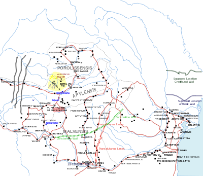
Līmes is a modern term used primarily for the Germanic border defence or delimiting system of Ancient Rome marking the borders of the Roman Empire, but it was not used by the Romans for that purpose. The term has been extended to refer to the frontier defences in other parts of the empire, such as in the east and in Africa.
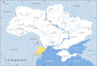
Budjak, also known as Budzhak, is a historical region that was part of Bessarabia from 1812 to 1940. Situated along the Black Sea, between the Danube and Dniester rivers, this multi-ethnic region covers an area of 13,188 km2 (5,092 sq mi) and is home to approximately 600,000 people. The majority of the region is now located in Ukraine's Odesa Oblast, while the remaining part is found in the southern districts of Moldova. The region is bordered to the north by the rest of Moldova, to the west and south by Romania, and to the east by the Black Sea and the rest of Ukraine.

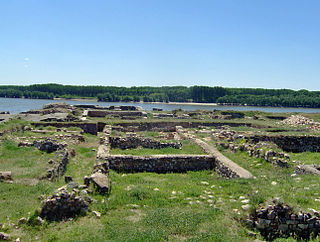
Novae was initially one of the few great Roman legionary fortresses along the empire's border, forming part of the defences along the Danube in northern Bulgaria. The settlement later expanded into a town in the Roman province of Moesia Inferior, later Moesia Secunda.

Oescus, Palatiolon or Palatiolum was an important ancient city on the Danube river in Roman Moesia. It later became known as Ulpia Oescus. It lay northwest of the modern Bulgarian city of Pleven, near the village of Gigen.

Trajan's Wall is the name used for several linear earthen fortifications (valla) found across Eastern Europe, Moldova, Romania, and Ukraine. Contrary to the name and popular belief, the ramparts were not built by Romans during Trajan's reign, but during other imperial periods. Furthermore, the association with the Roman Emperor may be a recent scholarly invention, only entering the imagination of the locals with the national awakening of the 19th century. Medieval Moldavian documents referred to the earthworks as Troian, likely in reference to a mythological hero in the Romanian and Slavic folklore. The other major earthen fortification in Romania, Brazda lui Novac, is also named after a mythological hero.

This is the history of Transnistria, officially the Pridnestrovian Moldavian Republic (PMR), an unrecognised breakaway state that is internationally recognised as part of Moldova. Transnistria controls most of the narrow strip of land between the Dniester river and the Moldovan–Ukrainian border, as well as some land on the other side of the river's bank.

The military history of Romania deals with conflicts spreading over a period of about 2500 years across the territory of modern Romania, the Balkan Peninsula and Eastern Europe and the role of the Romanian military in conflicts and peacekeeping worldwide.

The Moesian Limes is the modern term given to a collection of Roman fortifications between the Black Sea shore and Pannonia, present-day Hungary, consisting primarily of forts along the Danube to protect the Roman provinces of Upper and Lower Moesia south of the river.
The Upper Trajan's Wall is the modern name given to a fortification located in the central area of modern Moldavia. Some scholars consider it to be of Roman origin, while others think it was built in the third/fourth century by the Germanic Greuthungi to defend their borders against the Huns. It may also have been called Greuthungian Wall in later Roman accounts, but this is uncertain owing to a single polysemic manuscript occurrence in the works of Ammianus Marcellinus.
This deals with the History of Transnistria before it became part of the Russian Empire in 1792.

The Devil's Dykes, also known as the Csörsz árka or the Limes Sarmatiae, are several lines of Roman fortifications built mostly during the reign of Constantine the Great (306–337), stretching between today's Hungary, Romania and Serbia.
Vadul lui Isac is a village in Cahul District, Moldova.

Limes Transalutanus is the modern name given to a fortified frontier system of the Roman Empire, built on the western edge of Teleorman's forests in the Roman province of Dacia, modern-day Romania. The frontier was composed of a road following the border, a military stronghold, a three-metre vallum 10–12 metres wide, reinforced with wood palisades on stone walls, and also a ditch. The Transalutanus limes was 235 km long, parallel to Olt river at a distance varying from 5 to 30 km east of the river. The construction was started in 107 under the command of Marcius Turbo, and developed under Iulius Severus (120–126); the final stage of the construction was performed under Septimius Severus.
The Prut is a 953 km (592 mi) long river in Eastern Europe. It is a left tributary of the Danube. In part of its course it forms Romania's border with Moldova and Ukraine.

Noviodunum, known also as Noviodunum ad Istrum, was a fort and a port in the Roman province of Moesia located on the lower Danube.
The Danubian Limes, or Danube Limes, refers to the Roman military frontier or limes which lies along the River Danube in the present-day German state of Bavaria, in Austria, Slovakia, Hungary, Croatia, Serbia, Bulgaria and Romania.