Awarua Plains

Last updated

Awarua Plain (top), Tiwai Point (centre) and Bluff (lower left) viewed from the International Space Station in 2008. Awarua nasa.JPG
Awarua Plain (top), Tiwai Point (centre) and Bluff (lower left) viewed from the International Space Station in 2008.

The Awarua Plain is a large area of wetland to the east of Bluff, New Zealand. [1] Covering an area of around 600 km², the plain stretches for 35 kilometres along the coast of Foveaux Strait. This stretch of coast includes the peninsula of Tiwai Point, Awarua Bay, the Waituna Lagoon, and Toetoes Bay. The Mataura River is the major river responsible for the presence of the Awarua Plain; along with the Oreti River, it is a remnant of the rivers from the Ice Ages that formed the Southland Plains (Murihiku). In addition, several small streams enter Foveaux Strait along this stretch of coast, mainly via Awarua Bay and Waituna Lagoon.

Bluff, New Zealand human settlement

Bluff, previously known as Campbelltown and often referred to as "The Bluff", is a town and seaport in the Southland region, on the southern coast of the South Island of New Zealand. It is the southernmost town in mainland New Zealand and, despite Slope Point and Stewart Island being further south, Bluff is colloquially used to refer to the southern extremity of the country. According to the 2006 census, the resident population was 1,850, a decrease of 85 since 2001.

Foveaux Strait strait

Foveaux Strait (Te Ara a Kiwa or Te Ara a Kewa separates Stewart Island/Rakiura, New Zealand's third largest island, from the South Island. According to a Maori legend, the strait was created by Kewa the obedient whale when traditional Maori ancestor Kiwa summoned the whale to create a waterway. Three large bays, Te Waewae Bay, Oreti Beach and Toetoes Bay, sweep along the strait's northern coast, which also hosts Bluff township and harbour. Across the strait lie the Solander Islands, Stewart Island/Rakiura, Dog Island and Ruapuke Island. The strait is about 130 km long, and it widens and deepens from east to west. The strait lies within the continental shelf area of New Zealand, and was probably dry land during the Pleistocene epoch.

Tiwai Point

Tiwai Point lies at the entrance to Bluff Harbour on the southern coast of the South Island of New Zealand. A spit which extends from the western end of the Awarua Plain, it lies between Awarua Bay to the north and Foveaux Strait to the south. It is known for the Tiwai Point Aluminium Smelter, one of the largest industrial facilities in New Zealand.

Contents

Radio facilities

The Awarua Plain is suitable for radio facilities, due to low distant skylines, high ground conductivity[ citation needed ] and distance from sources of radio interference. [2] [3] An expedition seeking 'an extensive area of flat lands [producing] the best results' first scouted the area for radio purposes in 1911. [4]

Radio technology of using radio waves to carry information

Radio is the technology of using radio waves to carry information, such as sound and images, by systematically modulating properties of electromagnetic energy waves transmitted through space, such as their amplitude, frequency, phase, or pulse width. When radio waves strike an electrical conductor, the oscillating fields induce an alternating current in the conductor. The information in the waves can be extracted and transformed back into its original form.

A skyline is the horizon created by a city's overall structure, or by human intervention in a non-urban setting or in nature. City skylines serve as a pseudo-fingerprint as no two skylines are alike. For this reason, news and sports programs, television shows, and movies often display the skyline of a city to set a location. The term The Sky Line of New York City was first introduced in 1896, when it was the title of a color lithograph by Charles Graham for the color supplement of the New York Journal.

Radio-related facilities here are:

Unwin Radar

The Unwin Radar is a scientific radar array at Awarua, near Invercargill, New Zealand 46.51°S 168.38°E.

La Trobe University university in Victoria, Australia

La Trobe University is an Australian, multi-campus, public research university with its flagship campus located in the Melbourne suburb of Bundoora. The university was established in 1964, becoming the third university in the state of Victoria and the twelfth university in Australia. La Trobe is one of the Australian verdant universities, which are also part of the country’s Innovative Research Universities group.

Awarua Tracking Station

Awarua Tracking Station is an Earth station commissioned by and used by the European Space Agency located on the Awarua Plain in Southland, New Zealand. It was developed by Venture Southland, a joint committee of the Invercargill City Council, Southland District Council and Gore District Council. The station tracks Ariane 5 launch vehicles following their launch from the Guiana Space Centre in Kourou, French Guiana for the ATV missions.

Awarua Radio

Awarua Radio (callsign VLB or ZLB) was New Zealand's main receiving and transmitting coast radio station providing worldwide radiotelegraph and voice communications with ships at sea. Some facilities were built by Telefunken of Germany. It was operated from 18 December 1913 by the New Zealand Post Office (to 31 March 1986) then by NZPO successor corporation Telecom New Zealand until the station closed on 30 August 1991. [5]

Coast radio station

A coastradio station is an on-shore maritime radio station which may monitor radio distress frequencies and relays ship-to-ship and ship-to-land communications.

Telefunken German radio and television apparatus company, founded in Berlin in 1903; joint venture of Siemens & Halske and Allgemeine Elektricitäts-Gesellschaft (AEG)

Telefunken was a German radio and television apparatus company, founded in Berlin in 1903, as a joint venture of Siemens & Halske and the Allgemeine Elektricitäts-Gesellschaft (AEG).

Germany Federal parliamentary republic in central-western Europe

Germany, officially the Federal Republic of Germany, is a country in Central and Western Europe, lying between the Baltic and North Seas to the north, and the Alps to the south. It borders Denmark to the north, Poland and the Czech Republic to the east, Austria and Switzerland to the south, France to the southwest, and Luxembourg, Belgium and the Netherlands to the west.

The site was selected following an expedition in 1911 led by Mr J Orchiston, head of the New Zealand Telegraph Department, Captain Gard'ner of the New Zealand Artillery and representatives of Australian Wireless, seeking 'an extensive area of flat lands [producing] the best results'. [4]

The New Zealand Post Office (NZPO) was a government department of New Zealand until 1987. It was previously named the New Zealand Post and Telegraph Department.

New Zealand Army land component of the New Zealand Defence Force

The New Zealand Army is the land component of the New Zealand Defence Force and comprises around 4,500 Regular Force personnel, 2,000 Territorial Force personnel and 500 civilians. Formerly the New Zealand Military Forces, the current name was adopted by the New Zealand Army Act 1950. The New Zealand Army traces its history from settler militia raised in 1845.

Related Research Articles

Riverton, New Zealand Place in South Island, New Zealand

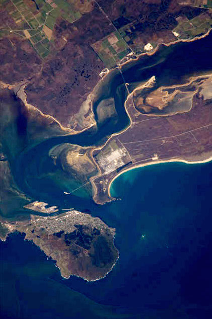
Riverton or Aparima is a small town 30 kilometres west of Invercargill via State Highway 99 on the Southern Scenic Route. It is situated on the south-eastern shorelines of the Jacobs River Estuary being formed by the Aparima and Pourakino Rivers, which leads through a narrow outflow channel into Foveaux Strait. The main part of the town is on flat land and the northern end of Oreti Beach but South Riverton is built on the hills between the eastern shore of the estuary and Taramea Bay.

Southland Plains

The Southland Plains is a general name given to several areas of low-lying land in the South Island of New Zealand, separated by the rise of the Hokonui Hills in the north. It forms a sizeable area of Southland region and encompasses its two principal settlements the city of Invercargill and the town of Gore. The Southland Plains include some of New Zealand's most fertile farmland.

Te Waewae Bay

Te Waewae Bay is the westernmost of three large bays lying on the Foveaux Strait coast of Southland, New Zealand, the others being Oreti Beach and Toetoes Bay. Twenty-seven kilometres in length, the western end of the bay is mountainous, with the southern terminus of the Southern Alps and Fiordland National Park.

Toetoes Bay

Toetoes Bay is the easternmost of three large bays lying on the Foveaux Strait coast of Southland, New Zealand, the others being Te Waewae Bay and Oreti Beach. The 190 km Mataura River drains to sea at Toetoes Bay, first passing through the Toetoes Harbour estuary. Thirty kilometres in length, the bay is the southern end of the Awarua Plain, an area of swampy land stretching inland for about fifteen kilometres. The eastern end of the bay is close to Slope Point, the South Island's southernmost point, and the western end of the Catlins.

Oreti Beach is the central bay of three lying on the Foveaux Strait coast of Southland, New Zealand, the others being Te Waewae Bay and Toetoes Bay. Twenty-six kilometres in length, the bay lies between the town of Riverton and the outflow of the Aparima River in the northwest, and the estuary of the Oreti River in the southeast.

Oreti River river in New Zealand

The Oreti River is one of the main rivers of Southland, New Zealand, and is 170 kilometres (110 mi) long. The river has been identified as an Important Bird Area by BirdLife International because, for much of its length, it supports breeding colonies of black-billed gulls.

The Aparima River, earlier known as Jacob's River, is one of the southward-flowing braided rivers of Southland, New Zealand.

Waiau River (Southland) river in New Zealand

Waiau River is the largest river in the Southland Region of New Zealand. It is the outflow of Lake Te Anau, flowing from it into Lake Manapouri 10 kilometres (6 mi) to the south, and from there flows south for 70 kilometres (43 mi) before reaching the Foveaux Strait 8 kilometres (5 mi) south of Tuatapere. It also takes water from Lake Monowai.

Colac Bay

Colac Bay/Oraka is a small township situated on the bay of the same name facing Foveaux Strait, and located on the Southern Scenic Route, 10 minutes from Riverton, New Zealand. Surrounding areas include Longwood, Tihaka, Waipango, Round Hill, Wakapatu, Ruahine, Pahia and Orepuki.

Kapuka South human settlement in New Zealand

Kapuka South is a locality in the Southland Region of New Zealand's South Island. It is situated on Toetoes Bay and Waituna Lagoon. Kapuka and Ashers are to the north on the Southern Scenic Route.

Awarua Wetland

The Awarua Wetland is a peatland area of 20,000 hectares in the Southland Region of New Zealand. The site, which was initially an area of about 3,556 hectares, was designated as having international significance under the Ramsar Convention in 1976, using the name Waituna Wetlands Scientific Reserve.

Stewart Island New Zealands third largest island, 30 km south of the South Island

Stewart Island is the third-largest island of New Zealand. It lies 30 kilometres (19 mi) south of the South Island, across the Foveaux Strait. Its permanent population is 381 people as of the 2013 census, most of whom live in the settlement of Oban on the eastern side of the island.

The Awarua River is a short river that flows from the Waiuna Lagoon into Big Bay, also known as Awarua Bay, an embayment at the northern end of Fiordland in New Zealand. The river's mouth is at the northern end of Three Mile Beach, the Big Bay beach. One of the rivers that feeds Waiuna Lagoon is the Dry Awarua River.

Big Bay (New Zealand)

Big Bay, also known as Awarua Bay, is a deep indentation in the southwestern coast of New Zealand's South Island, 40 kilometres north of Milford Sound and immediately to the north of Martins Bay. The bay is eight kilometres in width, and extends eight kilometres into the South Island, making an almost square indentation in the island's coastline. Its northern end is Awarua Point. Immediately beyond Long Reef, the rocky point at the southern end, is the mouth of the Hollyford River and Martins Bay. Big Bay has a sandy beach named Three Mile Beach. The Awarua River enters the bay at the northern end of the beach.

Waituna Lagoon

The Waituna Lagoon is on the southern coastline of the South Island of New Zealand. It forms part of the Awarua Wetland, a Ramsar site that was established in 1976.

Southland, New Zealand Region of New Zealand in South Island, New Zealand

Southland is New Zealand's southernmost region. It consists mainly of the southwestern portion of the South Island and Stewart Island / Rakiura. It includes Southland District, Gore District and the city of Invercargill. The region covers over 3.1 million hectares and spans over 3,400 km of coast.

Bluff Harbour bight in New Zealand

Bluff Harbour is a harbour and lagoon in the South Island, New Zealand town of Bluff. The main port facilities are located close to the entrance of a large natural inlet which includes a large, low-lying eastern arm, Awarua Bay, immediately to the east of the promontory which gives the town and harbour its name.

References

  1. "Place name detail: Awarua Plains". New Zealand Gazetteer. Land Information New Zealand . Retrieved 2009-11-27.
  2. NZ space link seen as a showcase for satellite imaging Archived 18 July 2011 at the Wayback Machine by NZPA, retrieved from Yahoo News website on 2011-02-15
  3. Unwin Radar Archived 18 December 2010 at the Wayback Machine on Venture Southland website, retrieved 2011-04-12
  4. 1 2 The Otago Daily Times , 1911-04-03, republished in 'Tea party in the Antarctic' on Otago Daily Times website, 2011-04-03
  5. Awarua Radio VLB - ZLB

Coordinates: 46°31′41″S168°28′54″E / 46.5281°S 168.4816°E / -46.5281; 168.4816

Geographic coordinate system Coordinate system

A geographic coordinate system is a coordinate system that enables every location on Earth to be specified by a set of numbers, letters or symbols. The coordinates are often chosen such that one of the numbers represents a vertical position and two or three of the numbers represent a horizontal position; alternatively, a geographic position may be expressed in a combined three-dimensional Cartesian vector. A common choice of coordinates is latitude, longitude and elevation. To specify a location on a plane requires a map projection.