
A beach is a landform alongside a body of water which consists of loose particles. The particles composing a beach are typically made from rock, such as sand, gravel, shingle, pebbles. The particles can also be biological in origin, such as mollusc shells or coralline algae.

Gironde is a department in the Nouvelle-Aquitaine region of southwest France. It is named after the Gironde estuary, a major waterway. The Bordeaux wine region is in the Gironde.

Singing sand, also called whistling sand or barking sand, is sand that produces sound. The sound emission may be caused by wind passing over dunes or by walking on the sand.

Barrier islands are coastal landforms and a type of dune system that are exceptionally flat or lumpy areas of sand that form by wave and tidal action parallel to the mainland coast. They usually occur in chains, consisting of anything from a few islands to more than a dozen. They are subject to change during storms and other action, but absorb energy and protect the coastlines and create areas of protected waters where wetlands may flourish. A barrier chain may extend uninterrupted for over a hundred kilometers, excepting the tidal inlets that separate the islands, the longest and widest being Padre Island of Texas. The length and width of barriers and overall morphology of barrier coasts are related to parameters including tidal range, wave energy, sediment supply, sea-level trends, and basement controls. The amount of vegetation on the barrier has a large impact on the height and evolution of the island.

Southwick Beach State Park is a New York State park that lies along an unusual stretch of sandy beach on the eastern shore of Lake Ontario. The park is 464 acres (188 ha) in size with a 3,500 foot (1,100 m) length of beach, and is visited annually by about 100,000 people. Immediately to the south is the Lakeview Wildlife Management Area, which extends the publicly accessible beach by several miles. They are in the Town of Ellisburg in Jefferson County, New York south of the lakeside community of Jefferson Park.
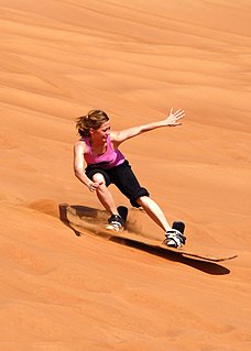
Sandboarding is a boardsport and extreme sport similar to snowboarding that involves riding across or down a sand dune while standing on a board, either with both feet strapped in or while standing loose, without bindings. Sandboarding can also be practised sitting down or lying on the belly or the back. It typically involves a sandboard, although it is also possible to use sleds, surfboards, a skateboard deck, or snowboards.

Indiana Dunes State Park is an Indiana State Park located in Porter County, Indiana, United States, 47 miles (75.6 km) east of Chicago. The park is bounded by Lake Michigan to the northwest, and is surrounded on all four sides by Indiana Dunes National Park, a unit of the National Park Service; the national park owns the water from the ordinary high water mark to 300 feet (91 m) offshore. The 1,530-acre (619.2 ha) Dunes Nature Preserve makes up the bulk of eastern part of the park, and includes most of the park’s hiking trails and dune landscape. This was one of the first places Richard Lieber considered when establishing the Indiana State Park system. Like all Indiana state parks, there is a fee for entrance. Indiana Dunes State Park was established in 1925 and designated a National Natural Landmark in 1974.

Guadalupe-Nipomo Dunes is the largest remaining dune system south of San Francisco and the second largest in the U.S. state of California. It encompasses an 18-mile (29 km) stretch of coastline on the Central Coast of California and extends from southern San Luis Obispo County to northern Santa Barbara County.

Seven Mile Beach is a long beach with strong historical reference just south of Gerringong in the Shoalhaven area of New South Wales, Australia.

Sandy Island Beach State Park is a New York State park on the eastern shore of Lake Ontario. Its highlight is a 1,500-foot (460 m) natural sandy beach. The park is near the southern end of a notable 17-mile (27 km) length of sandy shoreline, coastal dunes, and wetlands ; a 1959 study noted that "The eastern end of Lake Ontario contains not only the finest beaches on the entire lake but also the finest wildlife habitat."
The shoreline is where the land meets the sea and it is continually changing. Over the long term, the water is eroding the land. Beaches represent a special case, in that they exist where sand accumulated from the same processes that strip away rocky and sedimentary material. That is, they can grow as well as erode. River deltas are another exception, in that silt that erodes upriver can accrete at the river's outlet and extend ocean shorelines. Catastrophic events such as tsunamis, hurricanes, and storm surges accelerate beach erosion, potentially carrying away the entire sand load. Human activities can be as catastrophic as hurricanes, albeit usually over a longer time interval.

Sand dunes are common features of shoreline and desert environments. Dunes provide habitat for highly specialized plants and animals, including rare and endangered species. They can protect beaches from erosion and recruit sand to eroded beaches. Dunes are threatened by human activity, both intentional and unintentional. Countries such as the United States, Australia, Canada, New Zealand, the United Kingdom, and Netherlands, operate significant dune protection programs.

The Cronulla sand dunes, also known officially as the Cronulla Sand Dune and Wanda Beach Coastal Landscape, are a heritage-listed former sand mining, film making, pastoral property and visitor attraction and now nature conservation, open space and visitor attraction located on the Kurnell Peninsula at Lindum Road, Kurnell in the Sutherland Shire local government area of New South Wales, Australia. It is also known as Part of Kurnell Peninsula Headland and Cronulla Sand Hill. It was added to the New South Wales State Heritage Register on 26 September 2003.
Stockton Beach is located north of the Hunter River in New South Wales, Australia. It is 32 km (20 mi) long and stretches from Stockton, to Anna Bay. Over many years Stockton Beach has been the site of numerous shipwrecks and aircraft crash sites. In World War II it was fortified against a possible attack by Imperial Japanese forces. During that time it served as a bombing and gunnery range as well as a dumping area for unused bombs by aircraft returning from training sorties. The length of the beach, its generally hard surface and numerous items of interest along the beach make it popular with four-wheel drive (4WD) enthusiasts. Four-wheel drive vehicles are permitted to drive on Stockton Beach provided the vehicles are in possession of valid permits. The beach is also popular with fishermen and several different varieties of fish may be caught.
Sedimentary structures include all kinds of features formed at the time of deposition. Sediments and sedimentary rocks are characterized by bedding, which occurs when layers of sediment, with different particle sizes are deposited on top of each other. These beds range from millimeters to centimeters thick and can even go to meters or multiple meters thick.

Black Pond Wildlife Management Area is a 526-acre (213 ha) New York State Wildlife Management Area (WMA) that lies on the eastern shore of Lake Ontario, and at the northern limit of an unusual region of sandy barrier beaches and lagoons. Much of the barrier beach in Black Pond WMA has forested sand dunes that are about 60 feet (18 m) high; these are the highest sand dunes in the northeast United States excepting Cape Cod. Immediately north of the WMA is the 360-acre (150 ha) El Dorado Beach Preserve, which is a bird refuge owned by The Nature Conservancy. North of the outlet from Black Pond to Lake Ontario, the shoreline is a weathered, flat bedrock shelf that is "calcareous" instead of sandy.
Penhale Sands, or Penhale Dunes, is a complex of sand dunes and a protected area for its wildlife, on the north Cornwall coast in England, UK. It is the most extensive system of sand dunes in Cornwall and is believed to be the landing site of Saint Piran. Dating from the 6th century, St Piran's Oratory is thought to be one of the oldest Christian sites in Britain. The remains were discovered in the late 18th century, and in 2014 the covering sand was removed to reveal a building more than a thousand years old, in a reasonable state of preservation. A restricted military area dating from 1939, Penhale Camp, is found on the northern part of the dunes.
A foredune is a dune ridge that runs parallel to the shore of an ocean, lake, bay, or estuary. Foredunes consist of sand deposited by wind on a vegetated part of the shore. Foredunes can be classified generally as incipient or established.


