A pictogram, also called a pictogramme, pictograph, or simply picto, and in computer usage an icon, is a graphic symbol that conveys its meaning through its pictorial resemblance to a physical object. Pictographs are often used in writing and graphic systems in which the characters are to a considerable extent pictorial in appearance. A pictogram may also be used in subjects such as leisure, tourism, and geography.

Newspaper Rock State Historic Monument is a Utah state monument featuring a rock panel carved with one of the largest known collections of petroglyphs. It is located in San Juan County, along Utah State Route 211, 28 miles (45 km) northwest of Monticello and 53 miles (85 km) south of Moab.
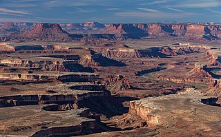
Canyonlands National Park is an American national park located in southeastern Utah near the town of Moab. The park preserves a colorful landscape eroded into numerous canyons, mesas, and buttes by the Colorado River, the Green River, and their respective tributaries. Legislation creating the park was signed into law by President Lyndon B. Johnson on September 12, 1964.

The Colorado Plateau, also known as the Colorado Plateau Province, is a physiographic and desert region of the Intermontane Plateaus, roughly centered on the Four Corners region of the southwestern United States. This province covers an area of 336,700 km2 (130,000 mi2) within western Colorado, northwestern New Mexico, southern and eastern Utah, northern Arizona, and a tiny fraction in the extreme southeast of Nevada. About 90% of the area is drained by the Colorado River and its main tributaries: the Green, San Juan, and Little Colorado. Most of the remainder of the plateau is drained by the Rio Grande and its tributaries.

The Fremont culture or Fremont people is a pre-Columbian archaeological culture which received its name from the Fremont River in the U.S. state of Utah, where the culture's sites were discovered by local indigenous peoples like the Navajo and Ute. In Navajo culture, the pictographs are credited to people who lived before the flood. The Fremont River itself is named for John Charles Frémont, an American explorer. It inhabited sites in what is now Utah and parts of Nevada, Idaho, Wyoming and Colorado from AD 1 to 1301. It was adjacent to, roughly contemporaneous with, but distinctly different from the Ancestral Pueblo peoples located to their south.

Horseshoe Bend is a horseshoe-shaped incised meander of the Colorado River located near the town of Page, Arizona, United States. It is also referred to as the "east rim of the Grand Canyon."

Thompson Springs, also officially known for a time as just Thompson, is a small census-designated place in central Grand County, Utah, United States. The population was 39 at the 2010 census. The town is just north of the east–west highway route shared by Interstate 70, U.S. Route 6 and U.S. Route 50, between Crescent Junction and Cisco. Moab, the county seat, is 37 miles (60 km) to the south. Thompson Springs is located in high desert country at an elevation of 5,246 feet (1,599 m), with the Book Cliffs just to the north. The town's ZIP code is 84540. The mystery "The Silver Spur Cafe" by Chinle Miller is partially set in Thompson Springs.

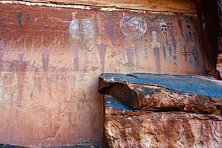
Horseshoe Canyon, formerly known as Barrier Canyon, is in a remote area west of the Green River and north of the Canyonlands National Park Maze District in Utah, United States. It is known for its collection of Barrier Canyon Style (BCS) rock art, including both pictographs and petroglyphs, which was first recognized as a unique style here. A portion of Horseshoe Canyon containing The Great Gallery is part of a detached unit of Canyonlands National Park. The Horseshoe Canyon Unit was added to the park in 1971 in an attempt to preserve and protect the rock art found along much of its length.

Coso Rock Art District is a rock art site containing over 100,000 Petroglyphs by Paleo-Indians and/or Native Americans. The district is located near the towns of China Lake and Ridgecrest, California. Big and Little Petroglyph Canyons were declared a National Historic Landmark in 1964. In 2001, they were incorporated into this larger National Historic Landmark District. There are several other distinct canyons in the Coso Rock Art District besides the Big and Little Petroglyph Canyons. Also known as Little Petroglyph Canyon and Sand Tanks, Renegade Canyon is but one of several major canyons in the Coso Range, each hosting thousands of petroglyphs. The majority of the Coso Range images fall into one of six categories: bighorn sheep, entopic images, anthropomorphic or human-like figures, other animals, weapons & tools, and "medicine bag" images.

Chumash rock art is a genre of paintings on caves, mountains, cliffs, or other living rock surfaces, created by the Chumash people of Southern California. Pictographs and petroglyphs are common through interior California, the rock painting tradition thrived until the 19th century. Chumash rock art is considered to be some of the most elaborate rock art tradition in the region.

The Prehistoric Museum, USU-Eastern, formerly known as the College of Eastern Utah Prehistoric Museum, is a museum accredited by the American Alliance of Museums located in Price, Utah. The museum seeks to promote public understanding of prehistory through interpretive exhibits, educational programs, collections, and research. The museum is located near many paleontological and archaeological sites in a region known as Castle Country, notably in the San Rafael Swell and nearby canyons throughout the Book Cliffs area such as Nine Mile Canyon and Range Creek Canyon.

The Buckhorn Draw Pictograph Panel is an example of rock art, located in Buckhorn Draw in the San Rafael Swell in central Utah, approximately four miles north of the San Rafael campground and bridge.

Painting in the Americas before European colonization is the Precolumbian painting traditions of the Americas. Painting was a relatively widespread, popular and diverse means of communication and expression for both religious and utilitarian purpose throughout the regions of the Western Hemisphere. During the period before and after European exploration and settlement of the Americas; including North America, Central America, South America and the islands of the Caribbean, the Bahamas, the West Indies, the Antilles, the Lesser Antilles and other island groups, indigenous native cultures produced a wide variety of visual arts, including painting on textiles, hides, rock and cave surfaces, bodies especially faces, ceramics, architectural features including interior murals, wood panels, and other available surfaces. Many of the perishable surfaces, such as woven textiles, typically have not been preserved, but Precolumbian painting on ceramics, walls, and rocks have survived more frequently.
The Quail rock art panel is a panel of Native American rock art located at the intersect of Grand Gulch and Step Canyon in Cedar Mesa, San Juan County, Utah. Grand Gulch contains a large number of relatively well-preserved rock art and ledge dwellings. The Quail Panel is a grouping of pictographs that were probably created by people of the Basketmaker II or Fremont culture. Cedar Mesa is located at a point where the two cultures overlapped.
The Observant Man Panel, also known as The Hidden Images Panel, is a panel of Barrier Canyon Style pictographs along the Swallow Nest Creek in Utah, United States.

Bluejohn Canyon is a slot canyon in eastern Wayne County, Utah, United States. It is on BLM land just south of the boundary of the Horseshoe Canyon Unit of Canyonlands National Park.
The Courthouse Wash Pictographs are a series of large pictographs created over a long period of time, located on a sheltered sandstone wall at the mouth of Courthouse Wash, Arches National Park in Grand County, Utah, United States, just north of Moab, that is listed on the National Register of Historic Places (NRHP).
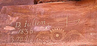
The Denis Julien Inscription is an incised carving on a rock face in a side canyon of the Green River north of Canyonlands National Park in southwestern Grand County, Utah, United States. The site is about 750 feet (230 m) to the east of the Green River in Hell Roaring Canyon, at the top of a talus slope. The inscription was left by trapper Denis Julien in 1836, when he was one of the few Europeans in southern Utah. The panel reads:
D. Julien
1836
3 mai
Denis Julien was an American fur trapper of French-Canadian Huguenot origin best known for his activity in the southwestern United States in the 1830s and 1840s, at a time when he was one of the few people of European descent in the area. He is principally remembered for his habit of leaving carved inscriptions on rock faces in Utah and Colorado during his travels. At least eight such markings have been positively attributed to him, four of which are listed on the National Register of Historic Places.


