Tampa Heights is one of the oldest neighborhoods within the city limits of Tampa, situated in the central part of the city. As of the 2000 census, the neighborhood had a population of 16,393.
West Tampa is one of the oldest neighborhoods within the city limits of Tampa, Florida, United States. It was an independently incorporated city from 1895 until 1925, when it was annexed by Tampa.
Seminole Heights is a historic neighborhood and district located in central Tampa. It includes many early 20th century bungalow homes and historic buildings. It was an early residential area of Tampa connected by streetcar. The area had an economic downturn in the late 20th century marked by increased crime, but has since seen a resurgence with new restaurants, brew pubs and independent businesses opening up. The neighborhood's historic homes, eclectic shops and gourmet restaurants are an increasing draw.

The Seminole Heights Residential District, known also as the Seminole Heights Historic District, is a U.S. and Local Historic District located in Tampa, Florida. The district is roughly bounded by Hanna Avenue to the north, Cherokee Avenue and I-275 to the east, Florida Avenue to the west, and Osborne Avenue to the south.
East Tampa is a district within the city limits of Tampa, Florida. As of the 2010 census the neighborhood had a population of 16,355. The ZIP Codes serving the neighborhood are 33605 and 33610. The district is about four miles northeast of Downtown Tampa.
Southeast Seminole Heights is a neighborhood within the Seminole Heights district of Tampa, Florida. As of the 2000 census the neighborhood had a population of 3,384. The ZIP Code of the neighborhood is 33603.

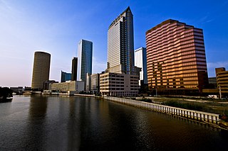
The cityscape of Tampa includes historic and architecturally noteworthy structures in its downtown and residential areas. The Seminole Heights and Hyde Park neighborhoods are two of the largest historic preservation districts in Tampa.
Riverside Heights is a neighborhood within the city limits of Tampa, Florida. As of the 2000 census the neighborhood had a population of 2,949. The ZIP Codes serving the area are 33602, 33603 and 33607.
South Seminole Heights is a neighborhood within the city limits of Tampa, Florida. As of the 2000 census the neighborhood had a population of 3,177. The ZIP Code serving the area is 33603.
Highland Pines is a neighborhood within the city limits of Tampa, Florida. As of the 2010 census the neighborhood had a population of 1,539. The ZIP Codes serving the neighborhood are 33605, 33610, and 33619. The neighborhood is part of the East Tampa region and is located within District Five of the Tampa City Council.
Jackson Heights is a neighborhood within the district of East Tampa, which represents District 5 of the Tampa City Council. Demographically, The neighborhood did not report separately. Jackson Heights boundaries are roughly 40th Street to the east, Hillsborough Avenue to the north, and 30th Street to the west.
Belmont Heights is a neighborhood within the district of East Tampa, which represents District 5 of the Tampa City Council. Demographically, The neighborhood did not report separately.
Robles Park is a neighborhood within the district of Tampa Heights, which represents District 5 of the Tampa City Council. Demographically, The neighborhood did not report separately. Robles Park is located at latitude 27.974 north and longitude 82.453 west. The elevation is 36 feet above sea level. The small neighborhood straddles between Florida and Nebraska Avenues and is mostly made up of a public housing complex known as Robles Park Village. It also contains a park and a collection of small single family home surrounding the public housing

Old Seminole Heights is a neighborhood within the city limits of Tampa, in the U.S. state of Florida. The neighborhood is one of three which comprise the greater Seminole Heights district within the city. As of the 2010 census the neighborhood had a population of 14,729. The ZIP Codes serving the area are 33603, 33604, and 33610.
Uptown Tampa is a subdistrict located at the western end of Downtown Tampa. Notable attractions include the Tampa Theatre,the Curtis Hixon Waterfront Park, the Tampa Bay Performing Arts Center and the John F. Germany Library. it is also known as the River Arts District and recently has been having a significant growth in population, activities, culture, and nightlife.
Audubon Park is a neighborhood within the district of South Tampa, which represents District 4 of the Tampa City Council. As of the 2000 census, the neighborhood recorded a population of 19. The ZIP Code serving the neighborhood is 33609.
Eastern Heights is a neighborhood within the district of East Tampa, which represents District 5 of the Tampa City Council. The 2000 census numbers are included with East Tampa. The latest estimated population was 192 and the population density was 2,730 people per square mile.
Harvey Heights is a neighborhood in the northern area of Tampa, Florida, which represents District 7 of the Tampa City Council. The 2000 census numbers were unavailable; however, the latest estimated population was 285.
Macfarlane Park is a neighborhood in the West Tampa district of Tampa, Florida, which represents District 6 of the Tampa City Council. The 2000 census numbers were unavailable, however, the latest estimated population was 1,754.