California State Route 107

Last updated

California 107.svg

State Route 107
Hawthorne Boulevard
California State Route 107.svg
SR 107 highlighted in red
Route information
Defined by Streets and Highways Code § 407
Maintained by Caltrans
Length4.801 mi [1] [2] (7.726 km)
Major junctions
South endCalifornia 1.svg SR 1 in Torrance
North endI-405 (1961).svg I-405 in Lawndale
Location
Counties Los Angeles
Highway system
I-105 (1961).svg I-105 SR 108 California 108.svg

State Route 107 (SR 107) runs from State Route 1 to Redondo Beach Boulevard at Lawndale via Hawthorne Boulevard in Torrance, California, United States.

Boulevard type of road

A boulevard, often abbreviated Blvd, is a type of large road, usually running through a city.

Lawndale, California City in California

Lawndale is a city in Los Angeles County, California, United States. The population was 32,769 at the 2010 census, up from 31,712 according to the 2000 census. The city is in the South Bay region of the Greater Los Angeles Area.

Torrance, California City in California

Torrance is a U.S. city in the South Bay (southwestern) region of Los Angeles County, California in the Los Angeles metropolitan area. Torrance has 1.5 miles (2.4 km) of beaches on the Pacific Ocean. Torrance has a moderate year-round climate with warm temperatures, sea breezes, low humidity, and an average rainfall of 12.55 inches per year.

Contents

Route description

Route 107 begins at State Route 1 in south Torrance and runs north along Hawthorne Boulevard in its entirety. (Hawthorne Boulevard continues south of Route 1 as Los Angeles County Route N-7.) The route is a principal arterial surface road in its entirety with grade crossings and maintains a wide right-of-way, often having as many as eight lanes and maintaining a 40 mph (60 km/h) speed limit. Route 107 goes through light and medium industrial areas and office towers. It also comes in contact with two malls: The South Bay Galleria and the Del Amo Fashion Center. It only met one other route along the way: State Route 91 at Artesia Boulevard, which has since been deleted.

Los Angeles County, California County in California, United States

Los Angeles County, officially the County of Los Angeles, is the most populous county in the Los Angeles metropolitan area of the U.S. state of California and is the most populous county in the United States, with more than 10 million inhabitants as of 2017. As such, it is the largest non-state level government entity in the United States. Its population is larger than that of 41 individual U.S. states. It is the third-largest metropolitan economy in the world, with a Nominal GDP of over $700 billion—larger than the GDPs of Belgium, Saudi Arabia, Norway, and Taiwan. It has 88 incorporated cities and many unincorporated areas and, at 4,083 square miles (10,570 km2), it is larger than the combined areas of Delaware and Rhode Island. The county is home to more than one-quarter of California residents and is one of the most ethnically diverse counties in the U.S. Its county seat, Los Angeles, is also California's most populous city and the nation's second largest city with about 4 million people.

SR 107 is part of the California Freeway and Expressway System, [3] and is part of the National Highway System, [4] a network of highways that are considered essential to the country's economy, defense, and mobility by the Federal Highway Administration. [5]

California Freeway and Expressway System highway system

The California Freeway and Expressway System is a system of existing or planned freeways and expressways in the U.S. state of California. It encompasses both State highways and federal highways in California. It is defined by the Streets and Highways Code, sections 250-257.

National Highway System (United States) highway system in the United States

The National Highway System (NHS) is a network of strategic highways within the United States, including the Interstate Highway System and other roads serving major airports, ports, rail or truck terminals, railway stations, pipeline terminals and other strategic transport facilities. Altogether, it constitutes the largest highway system in the world.

Federal Highway Administration government agency

The Federal Highway Administration (FHWA) is a division of the United States Department of Transportation that specializes in highway transportation. The agency's major activities are grouped into two programs, the Federal-aid Highway Program and the Federal Lands Highway Program. Its role had previously been performed by the Office of Road Inquiry, Office of Public Roads and the Bureau of Public Roads.

History

In 1964, Route 107 was defined to run past Interstate 405 along Hawthorne Boulevard, which renamed itself La Brea Avenue upon entering Inglewood at Century Boulevard, then turned west on Centinela Avenue to meet Interstate 405 again in Culver City. In 1965, the portion from Route 405 in Lawndale to Route 405 in Culver City was deleted. It was to have been upgraded to a freeway and was tentatively named the "Torrance Freeway."

Inglewood, California City in California, United States

Inglewood is a city in southwestern Los Angeles County, California in the Los Angeles metropolitan area. As of the 2010 U.S. Census, the city had a population of 109,673. It was incorporated on February 14, 1908. The city is in the South Bay region of Los Angeles County. Los Angeles Stadium at Hollywood Park is currently under construction in the city and, when completed around 2020, will be the new home of both the National Football League's Los Angeles Rams and Los Angeles Chargers. The city is also close to Los Angeles International Airport.

Culver City, California City in California, United States

Culver City is a city in Los Angeles County, California. The city was named after its founder, Harry Culver. As of the 2010 census, the city had a population of 38,883. It is mostly surrounded by the city of Los Angeles, but also shares a border with unincorporated areas of Los Angeles County. Over the years, it has annexed more than 40 pieces of adjoining land and now comprises about five square miles.

Until 1998, Route 107 continued further north to Interstate 405. In 1998, state law was changed to allow the relinquishment of Route 107 to the City of Lawndale. In 2003, the legislative definition was updated to eliminate the portion in Lawndale. The route currently ends at Redondo Beach Boulevard at the city limits of Lawndale.

Interstate 405 (I-405), also known as the San Diego Freeway is a major north–south Interstate Highway in Southern California. It is a bypass auxiliary route of Interstate 5, running along the southern and western parts of the Greater Los Angeles urban area from Irvine in the south to near San Fernando in the north. The entire route is known as the northern segment of the San Diego Freeway, and passes the Los Angeles International Airport (LAX).

Major intersections

Except where prefixed with a letter, postmiles were measured on the road as it was in 1964, based on the alignment that existed at the time, and do not necessarily reflect current mileage. R reflects a realignment in the route since then, M indicates a second realignment, L refers an overlap due to a correction or change, and T indicates postmiles classified as temporary (for a full list of prefixes, see the list of postmile definitions). [1] Segments that remain unconstructed or have been relinquished to local control may be omitted. The entire route is in Los Angeles County.

California postmile measurement

California uses a postmile highway location marker system on all of its state highways, including U.S. Routes and Interstate Highways. The postmile markers indicate the distance a route travels through individual counties, as opposed to milestones that indicate the distance traveled through a state. The postmile system is the only route reference system used by the California Department of Transportation (Caltrans).

In 1963 and 1964, the California Division of Highways implemented a major renumbering of its state highways. The majority of sign routes—those marked for the public—kept their numbers; the main changes were to the legislative routes, which had their numbers changed to match the sign routes. A large number of formerly unsigned routes received sign numbers corresponding to their new legislative numbers. A smaller change was the removal and truncating of many U.S. Routes in favor of the Interstate Highways, and the renumbering of State Routes that conflicted with Interstate numbers. Some U.S. Routes that were officially removed continued to be signed until the replacement Interstates were completed.

LocationPostmile
[1] [6] [7]
DestinationsNotes
Torrance 0.00CR N7 jct.svg CR N7 (Hawthorne Boulevard) Palos Verdes Estates Continuation beyond SR 1
0.00California 1.svg SR 1 (Pacific Coast Highway) Long Beach, Santa Monica South end of SR 107
0.74Lomita Boulevard
1.41 Sepulveda Boulevard
2.25Torrance Boulevard
Redondo Beach 3.68190th Street
4.70 Artesia Boulevard No left turn from Artesia Boulevard east. Former western segment of SR 91
Redondo BeachLawndale line4.79Redondo Beach BoulevardNorth end of state maintenance
Lawndale 5.62162nd Street
5.62I-405 (1961).svg I-405 (San Diego Freeway) Long Beach, Santa Monica Interchange; north end of SR 107; former SR 7
5.62 Hawthorne Boulevard Continuation beyond I-405
1.000 mi = 1.609 km; 1.000 km = 0.621 mi

See also

Related Research Articles

California State Route 91 highway in California

State Route 91 is a major east–west freeway located entirely within Southern California and serving several regions of the Greater Los Angeles urban area. Specifically, it currently runs from Vermont Avenue in Gardena, just west of the junction with the Harbor Freeway, east to Riverside at the junction with the Pomona, and Moreno Valley freeways.

California State Route 22 highway in California

State Route 22 in the U.S. state of California is an east–west highway in southern Los Angeles County and northern Orange County. It runs between Long Beach and Orange by way of Garden Grove. The westernmost part of it is a surface street, Long Beach's 7th Street. From West Garden Grove to its eastern terminus in Orange, it is known as the Garden Grove Freeway. It is one of the two principal east–west routes in Orange County.

Santa Ana Freeway highway in California

The Santa Ana Freeway is one of the principal freeways in Southern California, connecting Los Angeles and its southeastern suburbs including the freeway's namesake, the city of Santa Ana. The freeway begins at its junction with the San Diego Freeway, called the El Toro Y, in Irvine, signed as I-5. From there, it generally goes southeast to northwest to the East Los Angeles Interchange, where it takes the designation of U.S. Route 101 (US 101). It then proceeds 2.95 miles (4.75 km) northwest to the Four Level Interchange in downtown Los Angeles. Formerly, the entirety of the route was marked as US 101 until the 1964 highway renumbering, which truncated US 101 to the East Los Angeles Interchange and designated the rest of the freeway as I-5.

Ventura Freeway freeway in Southern California

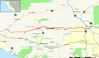
The Ventura Freeway is a freeway in southern California, United States, running from the Santa Barbara/Ventura county line to Pasadena in Los Angeles County. It is the principal east-west route through Ventura County and in the southern San Fernando Valley in Los Angeles County. From the Santa Barbara County line to its intersection with the Hollywood Freeway in the southeastern San Fernando Valley in Los Angeles, it is signed as U.S. Route 101, which was built in the late 1950s and opened on April 5, 1960. East of the Hollywood Freeway intersection, it is signed as State Route 134 which was built by 1971. The entire Ventura Freeway is not built to freeway standards, however; the segment that runs through the coastal communities of La Conchita and Mussel Shoals in western Ventura County still remains an expressway.

Interstate 105 (I-105) is an Interstate Highway in southern Los Angeles County, California that runs east–west from near the Los Angeles International Airport (LAX) to Norwalk. It is officially known as the Glenn Anderson Freeway for the Democratic California politician who advocated its construction. I-105 has also been referred to as the Century Freeway.

California State Route 238 highway in California

State Route 238 is a north–south highway in the U.S. state of California. The route is a divided multilane surface highway in the southeastern part of the San Francisco Bay Area. SR 238 connects Interstate 580 in Hayward and Interstate 680 in Fremont.

California State Route 92 highway in California

State Route 92 is an east-west highway in the San Francisco Bay area between Half Moon Bay near the coast in the west and downtown Hayward at its junction with State Route 238 and State Route 185. It is most notable for being the route that traverses the San Mateo Bridge. It has interchanges with three freeways: Interstate 280, U.S. Route 101 in or near San Mateo, and Interstate 880. It also connects indirectly to Interstates 238 and 580 by way of Hayward's Foothill Boulevard, which carries Route 238 and flows directly into Route 92.

California State Route 60 highway in California

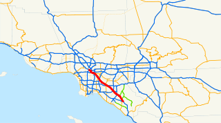
State Route 60 is an east-west state highway in the U.S. state of California. It runs from the East Los Angeles Interchange near downtown Los Angeles to an interchange with Interstate 10 (I-10) in Beaumont. The highway serves the cities and communities on the eastern side of the Los Angeles metropolitan area and runs along the south side of the San Gabriel Valley. The highway provides a route across several spurs of the Peninsular Ranges, linking the Los Angeles Basin with the Pomona Valley and San Gabriel Valley. It runs from the East Los Angeles Interchange near the Los Angeles River in Los Angeles with Interstate 5 (I-5), Interstate 10 (I-10) and U.S. Route 101 east to I-10 in Riverside County, with overlaps at State Route 57 and Interstate 215. The highway runs roughly parallel to Interstate 10, functioning as a bypass alternate route east-west route through the area.

California State Route 2 highway in California

State Route 2 is a state highway in the U.S. state of California. Officially, it begins at the intersection of Centinela Avenue in the City of Los Angeles limits adjacent to the city of Santa Monica and extends all the way to SR 138 east of Wrightwood. The highway currently is divided into three segments, briefly runs concurrent with U.S. Route 101 and Interstate 210 (I-210) to connect the segments. The western section of the highway is an old routing of U.S. Route 66; the eastern portion is known as the Angeles Crest Highway, while the middle section is known as the Glendale Freeway along with multiple surface streets around Route 101.

California State Route 72 highway in California

State Route 72 is a state highway in the U.S. state of California. The route runs along Whittier Boulevard from I-605 in Whittier to SR-39 in La Habra. SR 72 forms part of El Camino Real.

California State Route 118 highway in California

State Route 118 is a state highway in the U.S. state of California that begins running west to east through Ventura and Los Angeles counties in southern California. It travels from the eastern edge of Ventura immediately northwest of Saticoy, then through Saticoy, in Ventura County east to Lake View Terrace in Los Angeles. Route 118 crosses the Santa Susana Pass and the northern rim of the San Fernando Valley along its route.

California State Route 71 highway in California

State Route 71, the Chino Valley Freeway and the Corona Freeway, formerly the Corona Expressway and before then the Temescal Freeway, is a freeway of about 15 miles (24 km) in length located entirely within Southern California, United States.

California State Route 19 highway in California

State Route 19, also known as Lakewood Boulevard and Rosemead Boulevard, is a state highway in the Los Angeles area of the U.S. state of California. The route is a north–south four-to-six lane suburban roadway, lying between the Long Beach Freeway (I-710) and San Gabriel River Freeway (I-605), and connecting the eastern parts of Long Beach and Pasadena via the Whittier Narrows. Since 1998, several pieces have been relinquished to local governments, and more transfers are authorized by state law. The portion of SR 19 north of the Whittier Narrows is officially State Route 164, once planned to be upgraded as the Rio Hondo Freeway, but has always been signed as part of SR 19.

California State Route 90 highway in California

State Route 90 is a state highway in Southern California, United States. It consists of two unconnected pieces in Greater Los Angeles.

California State Route 66 highway in California

State Route 66 is a state highway in the U.S. state of California, running along the section of old U.S. Route 66 in California from La Verne east to San Bernardino, passing through Claremont, Upland, Rancho Cucamonga, Fontana and Rialto along Foothill Boulevard. In San Bernardino, it is the part of Fifth Street west of H Street.

California State Route 27 highway in California

State Route 27 is a state highway in the U.S. state of California that runs from Pacific Coast Highway (PCH) at Topanga State Beach near Pacific Palisades, through Topanga Canyon including the community of Fernwood Pacific also known as Topanga, and continuing through Woodland Hills, Canoga Park, West Hills, and Chatsworth to Ronald Reagan Freeway. The entire route is commonly known by its street name, Topanga Canyon Boulevard.

State Route 103, part of the Terminal Island Freeway, is a short state highway in Los Angeles and Long Beach. It runs from a split with State Route 47 northeast to a cloverleaf interchange with State Route 1. Beyond SR 1, the freeway is not State Route 103 but is technically known as State Route 103U, wherein the “U” stands for “unrelinquished,” due to the fact that the route north of Route 1 is not defined as part of Route 103 but formerly was, and when the route was truncated no legislation has been passed by the state legislature to hand over ownership of such portion of the route to the City of Long Beach. South of the end of SR 103, the Terminal Island Freeway runs south with SR 47 over the Commodore Schuyler F. Heim Bridge to its end at Ocean Boulevard on Terminal Island, at the former Long Beach Naval Shipyard. SR 47 turns west there to its end at Interstate 110.

California State Route 42 former highway in California

State Route 42 is a decommissioned state highway in southern region of the U.S. state of California, running along Manchester Avenue, Manchester Boulevard and Firestone Boulevard in Los Angeles and the cities south of it. After 1968, it ran from State Route 1 west of Inglewood east to Interstate 5 in Norwalk. Though signed as SR 42, it was officially Route 105 until replaced by the parallel Interstate 105 October 14, 1993. The entire route was deleted from the California Freeway and Expressway System in 2000, with the remaining portion of SR 42 being relinquished to local jurisdictions in that year, but the route is still signed off as SR 42.

California State Route 187 highway in California

California State Route 187 in Los Angeles is the portion of Venice Boulevard between Lincoln Boulevard in Venice and its intersection with Interstate 10 in the South Robertson district.

California State Route 213 highway in California

State Route 213 is a state highway in the U.S. state of California, in Los Angeles County. The California Legislature has designated the route as Western Avenue from 25th Street in San Pedro north to the San Diego Freeway. From 25th Street to Carson Street, the California Transportation Commission has adopted Western Avenue as a State highway; however, the northerly two miles from Carson Street to Interstate 405 in Torrance has not, as yet, been adopted and remains a city street. Beyond Interstate 405, Western Avenue, continues through Torrance, Gardena, and Los Angeles to Los Feliz Boulevard in Hollywood as a city street.

References

  1. 1 2 3 California Department of Transportation. "State Truck Route List". Sacramento: California Department of Transportation. Archived from the original (XLS file) on June 30, 2015. Retrieved June 30, 2015.
  2. Portions of this route have been relinquished to or are otherwise maintained by local or other governments, and are not included in the length.
  3. California State Legislature. "Section 250–257". Streets and Highways Code. Sacramento: California State Legislature. Retrieved June 9, 2017.
  4. Federal Highway Administration (March 25, 2015). National Highway System: Los Angeles, CA (PDF) (Map). Scale not given. Washington, DC: Federal Highway Administration. Retrieved October 1, 2017.
  5. Natzke, Stefan; Neathery, Mike & Adderly, Kevin (June 20, 2012). "What is the National Highway System?". National Highway System. Washington, DC: Federal Highway Administration. Retrieved July 1, 2012.
  6. California Department of Transportation (July 2007). "Log of Bridges on State Highways". Sacramento: California Department of Transportation.
  7. California Department of Transportation, All Traffic Volumes on CSHS, 2005 and 2006

Route map:

KML file (edithelp)
    KML is from Wikidata