Cantre'r Gwaelod

Last updated
Cantre'r Gwaelod
The Lowland Hundred
Welsh mythology location
Submerged forest at Ynyslas, Ceredigion.jpg
Part of an ancient submerged forest at Ynyslas thought to be associated with Cantre'r Gwaelod
GenreLegend
In-universe information
Type Sunken kingdom
LocationsCaer Wyddno
Characters

Cantre'r Gwaelod, also known as Cantref Gwaelod or Cantref y Gwaelod ( Welsh for 'The Lowland Hundred'), is a legendary ancient sunken kingdom said to have occupied a tract of fertile land lying between Ramsey Island and Bardsey Island in what is now Cardigan Bay to the west of Wales. It has been described as a "Welsh Atlantis" and has featured in folklore, literature, and song.

Contents

The legend

Cantre'r Gwaelod was an area of land which, according to legend, was located in an area west of present-day Wales which is now under the waters of Cardigan Bay. Accounts variously suggest the tract of land extended from Bardsey Island to Cardigan or as far south as Ramsey Island. [1] Legends of the land suggest that it may have extended 20 miles west of the present coast. [2]

There are several versions of the myth. The earliest known form of the legend is usually said to appear in the Black Book of Carmarthen , in which the land is referred to as Maes Gwyddno (English: the Plain of Gwyddno). In this version, the land was lost to floods when a well-maiden named Mererid neglected her duties and allowed the well to overflow. [2]

The popular version known today is thought to have been formed from the 17th century onwards. Cantre'r Gwaelod is described as a low-lying land fortified against the sea by a dyke, Sarn Badrig ("Saint Patrick's causeway"), with a series of sluice gates that were opened at low tide to drain the land. [2]

Cantre'r Gwaelod's capital was Caer Wyddno, seat of the ruler Gwyddno Garanhir. Two princes of the realm held charge over the dyke. One of these princes, called Seithenyn, is described in one version as a notorious drunkard and carouser, and it was through his negligence that the sea swept through the open floodgates, ruining the land.

The church bells of Cantre'r Gwaelod are said to ring out in times of danger.

Relationship to myth of Llys Helig

Rachel Bromwich raises questions over the location, stating: "There is no certainty, however, that in twelfth century tradition Maes Gwyddneu did represent the submerged land in Cardigan Bay." She also links Gwyddno Garanhir with the Old North, not Wales. [3] She further discusses a similar tale, that of the submergence of the kingdom of Helig ap Glanawg in the Conwy estuary. As with Cantre'r Gwaelod, there are tales of remains being seen of the sunken kingdom (Llys Helig). Bromwich believes that the two stories influenced each other, and that "The widespread parallels to this inundation theme would suggest that the two stories are in fact one in origin, and were localized separately in Cardiganshire and in the Conway estuary, around two traditional figures of the sixth century. She also notes that J.O Halliwell in his 1859 text An Ancient Survey of Pen Maen Mawr gives Helig the title "Lord of Cantre'r Gwaelod". [3] In the book New Directions In Celtic Studies Antone Minard wrote that "The Welsh legends of Cantre'r Gwaelod and Llys Helig (Helig's Court) contain the same details of audible bells beneath the waves and ruins which are visible at the equinoctial tides, which are the anchors of credulity in the story". [4]

Relationship to myth of Teithi Hen

In the tale of Culhwch and Olwen, one of the Welsh Triads, one of the men at Arthur's court is named as Teithi Hen ap Gwynnan, whose land was inundated, and only he escaped. He is also mentioned in Cronica de Wallia, part of the Annales Cambriae, and the lost land is called Ynys Teithi Hen. This legend has similarities to Cantre'r Gwaelod but there is no direct connection with Seithennin. The location is placed west of Dyfed, [5] or between Anglesey and Ireland. [6] :27

Physical evidence

Cardigan Bay, supposed location of Cantre'r Gwaelod CardiganBay.svg
Cardigan Bay, supposed location of Cantre'r Gwaelod

There is no reliable physical evidence of the substantial community that according to legend lies under the sea, although there are several reports of remains being sighted.

In 1770, Welsh antiquarian scholar William Owen Pughe reported seeing sunken human habitations about four miles (6 km) off the Ceredigion coast, between the rivers Ystwyth and Teifi. [7]

In the 1846 edition of The Topographical Dictionary of Wales, Samuel Lewis described a feature of stone walls and causeways beneath the shallow waters of Cardigan Bay:

In the sea, about seven miles west of Aberystwyth in Cardiganshire, is a collection of loose stones, termed Caer Wyddno, "the fort or palace of Gwyddno;" and adjoining it are vestiges of one of the more southern causeways or embankments of Catrev Gwaelod. The depth of water over the whole extent of the bay of Cardigan is not great; and on the recess of the tide, stones bearing Latin inscriptions, and Roman coins of various emperors, have been found below high-water mark: in different places in the water, also, are observed prostrate trees."

Samuel Lewis, The Topographical Dictionary of Wales. [7]

Lewis takes the view that maps by the cartographer Ptolemy marked the coastline of Cardigan Bay in the same location as it appears in modern times, suggesting that the flood occurred before the second century AD.

The "causeways" described by Lewis can be seen today at beaches around Cardigan Bay. Known as sarnau, these ridges stretch several miles into the sea at right angles to the coast, and are located between each of the four river mouths in the north of Cardigan Bay. Modern geologists surmise that these formations of clay, gravel and rocks are moraines formed by the action of melting glaciers at the end of the last ice age. In a 2006 episode of the BBC television documentary Coast , presenter Neil Oliver visited Sarn Gynfelyn at Wallog. The programme also showed the remains of the submerged forest at Ynyslas, near Borth which is associated with the lost land of Cantre'r Gwaelod. [8] The vista of dead oak, pine, birch, willow and hazel tree stumps preserved by the acid anaerobic conditions in the soil is revealed at low tide; storms in 2010 and 2014, and particularly Storm Hannah in 2019, have eroded the sea-bed offshore and revealed more stumps. [9] The forest is estimated to have been submerged between 4,000 and 5,000 years ago. [10] [11] [9]

Evidence of human habitation includes a timber walkway made of coppiced branches and upright posts, human footprints preserved in hardened peat, and burnt stones thought to be from hearths. [12]

In 2022, geographer Simon Haslett and linguist David Willis published research suggesting that the medieval Gough Map provides evidence for two offshore islands within Cardigan Bay. These were suggested as "likely to be the remnants of a low-lying landscape underlain by soft glacial deposits laid down during the last ice age which has since been dissected by rivers and truncated by the sea". [13] [14]

Images

Origins of the myth

Comparable Celtic myths describe a submerged kingdom near Brittany or Cornwall Coccoliths in the Celtic Sea-NASA.jpg
Comparable Celtic myths describe a submerged kingdom near Brittany or Cornwall

The myth, like so many others, may be a folk memory of gradually rising sea levels at the end of the ice age. The physical remains of the preserved sunken forest at Borth, and of Sarn Badrig nearby, could have suggested that some great tragedy had overcome a community there long ago and so the myth may have grown from that. [11]

Analogies in other legends

The legend of Cantre'r Gwaelod is comparable to the deluge myth found in nearly every ancient culture and it has been likened to the story of Atlantis. [14]

Several similar legends exist in Celtic mythology which refer to a lost land beneath the waves. Both the Breton legend of Ker-Ys and the Arthurian tale of Lyonesse refer to a kingdom submerged somewhere in the Celtic Sea, off the coast of Brittany or Cornwall respectively. A weaker parallel is the Gaelic otherworld Tír na nÓg ('Land of Youth'), often conceived of a mystical land reached via a sea voyage; however, it lacks an inundation myth.

Cultural references

Literature

The legend has inspired many poems and songs throughout the ages. The earliest mention of Cantre'r Gwaelod is thought to be in the thirteenth-century Black Book of Carmarthen in a poem called Boddi Maes Gwyddno (English: The Drowning of the Land of Gwyddno) which relates the tale of Mererid and the well.

The story inspired a Victorian era-novel, The Misfortunes of Elphin (1829), by Thomas Love Peacock. [15] At the 1925 National Eisteddfod of Wales, held in Pwllheli, Dewi Morgan ('Dewi Teifi') won the Bardic Chair with his Awdl recounting the legend, adopting Thomas Love Peacock's version as the basis for his poetic rendition.

Ptolemy's map of Great Britain and Ireland (1467 copy) Ptolemy Cosmographia 1467 - Great Britain and Ireland.jpg
Ptolemy's map of Great Britain and Ireland (1467 copy)

Geologist William Ashton's 1920 book, The Evolution of a Coast-Line, Barrow to Aberystwyth and the Isle of Man, with Notes on Lost Towns, Submarine Discoveries, &C, discusses the legend and takes Ptolemy's map as evidence of the existence of an area of lost land in Cardigan Bay. Ashton also includes a conjectural map of Cantre'r Gwaelod within the bay. [16]

Cantre'r Gwaelod is also featured in modern children's literature. Cantre'r Gwaelod is central to the setting of the 1977 Newbery Honor Book A String in the Harp by Nancy Bond. The kingdom also plays a major role in Silver on the Tree, the last book of The Dark Is Rising by Susan Cooper, parts of which are set in Aberdyfi. Siân Lewis and Jackie Morris's book Cities in the Sea (2002) retells the legend for children, [17] and Welsh musician Cerys Matthews's first children's book Tales from the Deep (2011) features a story, The Ghost Bells of the Lowlands, which was adapted from the legend of Cantre'r Gwaelod. [18]

Music and art

The bells of St Peter's, Aberdyfi can play Clychau Aberdyfi St Peter's Church and Terrace Road Aberdyfi - geograph.org.uk - 1005740.jpg
The bells of St Peter's, Aberdyfi can play Clychau Aberdyfi

The folk song Clychau Aberdyfi ("The Bells of Aberdovey"), popularised in the 18th century, relates to the part of the legend about the bells being heard ringing beneath the waves in the town of Aberdyfi. This song inspired cultural projects in the town involving bells; a new chime of bells was installed in September 1936 in the tower St Peter's Church, Aberdyfi, specifically designed to allow the playing of The Bells of Aberdovey. [19] An art installation by the sculptor Marcus Vergette, a bronze "Time and Tide Bell", was mounted beneath the jetty in Aberdyfi Harbour in July 2011 as a homage to the folk song. The bell is rung by the action of water at high tide. [20] [21] The story of Cantre'r Gwaelod was the theme of the song entitled "Y Bobl" that competed in the final of Cân i Gymru 2021, which was written by Daniel Williams and performed by Lily Beau.

Local representation

In the 1990s the village of Aberdyfi had a small primary school which changed its school badge to show a raven surrounded by bells on a shield. The raven represented the nearby Corbett Estate which owned a large amount of land and built a number of houses. The raven can be seen on various buildings in the area. The school has since been closed and demolished, making way for affordable housing.

Television

An episode of the BBC CBeebies programme Telly Tales , first broadcast in 2009, featured a children's re-enactment of the legend of Cantre'r Gwaelod through a mixture of animation and live action. [22]

Cantre'r Gwaelod featured in the BBC documentary series Coast . Presenter Neil Oliver visited the sands of Aberdyfi and Ynyslas, near Borth, and examined the remains of the submerged forest and Sarn Badrig which are revealed at low tide, assisted by local historians and dendrochronologists. [10] [11]

See also

Related Research Articles

Gwyddno Garanhir was the supposed ruler of a sunken land off the coast of Wales, known as Cantre'r Gwaelod. He was the father of Elffin ap Gwyddno, the foster-father of the famous Welsh poet Taliesin in the legendary account given in the late medieval Chwedl Taliesin.

<span class="mw-page-title-main">Borth</span> Seaside village in Wales

Borth is a village and seaside resort in Ceredigion, Mid Wales; it is located 7 miles (11 km) north of Aberystwyth, on the Ceredigion Coast Path. The community includes the settlement of Ynyslas and the population was 1,399 in 2011. From being largely Welsh-speaking, the village has become anglicised; over 54 per cent of its residents were born in England. According to both the 1991 and 2001 censuses, 43 per cent of the residents of Borth were primarily Welsh-speakers.

<span class="mw-page-title-main">Cardigan Bay</span> Bay in Wales

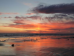
Cardigan Bay is a large inlet of the Irish Sea, indenting the west coast of Wales between Bardsey Island, Gwynedd in the north, and Strumble Head, Pembrokeshire at its southern end. It is the largest bay in Wales.

<span class="mw-page-title-main">Aberdyfi</span> Village and community in Gwynedd, Wales

Aberdyfi, also known as Aberdovey, is a village and community in Gwynedd, Wales, located on the northern side of the estuary of the River Dyfi.

<span class="mw-page-title-main">Cantref</span> Medieval Welsh land division

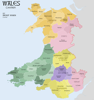
A cantref was a medieval Welsh land division, particularly important in the administration of Welsh law.

<span class="mw-page-title-main">Sarn Badrig</span> Shingle reef in Cardigan Bay, Wales

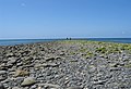
Sarn Badrig, also spelled Sarn Padrig, is one of several more or less parallel shingle reefs extending under the sea in Cardigan Bay on the west coast of Wales. The causeway is made of glacial deposits left by receding ice sheets at the end of the last ice age.

Seithenyn sometimes known as Seithenyn of the feeble mind is a figure from Welsh legend, apparently contemporary with King Gwyddno Garanhir. He is mentioned in a poem in the Llyfr Du Caerfyrddin, but becomes the protagonist of the story in a later version of the legend, in which he was responsible for the sea-defences of Cantre'r Gwaelod or Maes Gwyddno, in the kingdom of the legendary Gwyddno Garanhir, but neglected them one night because of his drunkenness. Because of this neglect, the sea overran it.

<span class="mw-page-title-main">Ynyslas</span> Village in Ceredigion, Wales

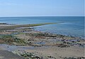
Ynyslas is a small village about 1.5 miles north of Borth and 8 miles north of Aberystwyth, within the county of Ceredigion, Wales. It is sandwiched between a long sandy beach in Cardigan Bay and the beach in the Dyfi Estuary. The area between the sea and the estuary beach is made up of the Ynyslas Sand Dunes which are part of the Dyfi National Nature Reserve and home to many rare plants and animals. The sands of the estuary beach can be driven onto and parked upon. The nature reserve has a visitor centre with toilets and a small shop. At the start of some BBC 1 programmes, it shows people flying kites on the sand dunes, this was filmed at Ynyslas.

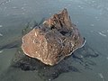
Helig ap Glanawg is a legendary figure described in various accounts dating to at least as early as the 13th century as a 6th-century prince who lived in North Wales.

Llys Helig is the name of a natural rock formation off the coast at Penmaenmawr, north Wales. There may be a fish weir to the south which tradition dates to the beginning of the 6th century. The sea level was low enough around 1600 AD to make the claims of Sir John Wynne of Gwydir feasible. The earliest known use of the name Llys Helig for this rock formation is the Halliwell Manuscript which is believed to date to around the beginning of the 17th century, eleven centuries later. Legends developed about it suggesting that it was the palace of Prince Helig ap Glanawg who lived in the 6th century, and whose sons established a number of churches in the area. He owned a large area of land between the Great Orme's Head near Llandudno and the Menai Strait off the north coast of Gwynedd.

<span class="mw-page-title-main">Ceredigion Coast Path</span> Long-distance footpath following the coast of Ceredigion, Wales

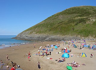
The Ceredigion Coast Path is a waymarked long distance footpath in the United Kingdom, on the coast of Ceredigion, Wales. It is 65 miles (105 km) in length, running along the coast of Cardigan Bay from Cardigan (52.0810°N 4.6608°W) to Ynyslas (52.5271°N 4.0495°W).

<span class="mw-page-title-main">Ynyslas Sand Dunes</span> Sand dunes in Ceredigion, Wales

Ynyslas Sand Dunes are sand dunes located in Ceredigion, Wales. They border Cardigan Bay and the Dyfi Estuary between Ynyslas, Ceredigion and Aberdyfi, Gwynedd. The sand dunes are part of the Dyfi National Nature Reserve.

<span class="mw-page-title-main">Afon Leri</span> River in Wales

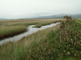
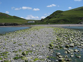
Afon Leri is a river in Ceredigion, Wales. It rises at Llyn Craig-y-Pistyll and is joined at Talybont by Afon Ceulan before passing behind Borth to its mouth in the Dyfi estuary at Ynyslas.

<span class="mw-page-title-main">Tre-Taliesin</span> Human settlement in Wales

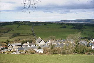
Tre-Taliesin is a village in Ceredigion on the A487 road, 9 miles north of Aberystwyth, Wales, and 9 miles south of Machynlleth. It is in the parish of Llangynfelyn.

<span class="mw-page-title-main">Sarn Gynfelyn</span> Shingle spit on Cardigan Bay, Wales

Sarn Gynfelyn is a shingle spit on the coast of Cardigan Bay, in the county of Ceredigion, Mid-Wales, in the United Kingdom. It is located at Wallog, a few kilometres north of Llangorwen, close to Clarach Bay, south of Borth and north of the town of Aberystwyth. It extends, albeit with a single break, for a distance of 11km from the coast to a reef known as Patches or Caerwyddno.

Sarn y Bwch,, is one of three parallel reefs extending beneath the sea into Cardigan Bay from the west coast of Wales. The causeway, probably a medial moraine is made of glacial deposits left by receding ice sheets at the end of the last ice age. It is sometimes called Sarn y Bwlch, but this form is later and less common than Sarn y Bwch.

<span class="mw-page-title-main">Golf in Wales</span>

Golf is a popular sport in Wales. Although the sport of golf in Great Britain is most associated with Scotland, where it was established and developed, Wales can record its first courses back to the 1880s, and today has over 200 clubs. The first amateur golf competition was held in 1895, and the first professional championship was in 1904. Wales has produced several players of note, including one player, Ian Woosnam, who has won one of the Men's major golf championships and Wales has twice won the men's World Cup, in 1987 and 2005, respectively. Wales also hosted the Ryder Cup, when it was held at Newport's Celtic Manor Resort in 2010.

The Bells of Aberdovey is a popular song which refers to the village now usually known locally by its Welsh-language name of Aberdyfi in Gwynedd, Wales at the mouth of the River Dyfi on Cardigan Bay. The song is based on the legend of Cantre'r Gwaelod, which is also called Cantref Gwaelod or Cantref y Gwaelod. This ancient sunken kingdom is said to have occupied a tract of fertile land lying between Ramsey Island and Bardsey Island in what is now Cardigan Bay to the west of Wales. The legend supposes that the bells of the submerged lost kingdom can be heard ringing below the waves on the beach at Aberdyfi.

<span class="mw-page-title-main">Coastline of Wales</span> Sea-bounded areas of Wales

The coastline of Wales extends from the English border at Chepstow westwards to Pembrokeshire then north to Anglesey and back eastwards to the English border once again near Flint. Its character is determined by multiple factors, including the local geology and geological processes active during and subsequent to the last ice age, its relative exposure to or shelter from waves, tidal variation and the history of human settlement and development which varies considerably from one place to another. The majority of the coast east of Cardiff in the south, and of Llandudno in the north, is flat whilst that to the west is more typically backed by cliffs. The cliffs are a mix of sandstones, shales and limestones, the erosion of which provides material for beach deposits. Of the twenty-two principal areas which deliver local government in Wales, sixteen have a coastline, though that of Powys consists only of a short section of tidal river some distance from the open sea. Its length has been estimated at 1,680 miles (2,700 km).

References

  1. Gwyndaf, Robin (1989). "34. Cantre'r Gwaelod, Dyfed". Welsh folk tales/Chwedlau gwerin Cymru (2 ed.). Cardiff: National Museum Wales/Amgueddfa Genedlaethol Cymru. ISBN   978-0-7200-0326-0.
  2. 1 2 3 "Cantre'r Gwaelod – The Lost Land of Wales". Legacies - UK History Local to You. BBC. Retrieved 4 January 2012.
  3. 1 2 Rachel Bromwich (1950). "Cantre'r Gwaelod and Ker-Is". In Cyril Fox, Bruce Dickins (ed.). The Early Cultures of North-West Europe. Cambridge University Press. p. 231.
  4. Antone Minard (2000). "Pre-Packaged Breton Folk Narrative". In Amy Hale and Philip Payton (ed.). New Directions In Celtic Studies. University of Exeter Press. p. 60. ISBN   9780859896221.
  5. Bartrum, Peter Clement (1993). A Welsh Classical Dictionary - National Library of Wales. Aberystwyth: National Library of Wales. Retrieved 12 February 2024.
  6. Sterckx, Claude (2008). "Les deux boeufs du déluge et la submersion de la ville d'Is". Annales de Bretagne et des pays de l'Ouest (115–1): 12-49ers 5. doi:10.4000/abpo.346.
  7. 1 2 Haughton, Brian (2008). Haunted spaces, sacred places : a field guide to stone circles, crop circles, ancient tombs, and supernatural landscapes . Franklin Lakes, NJ: New Page Books. p.  100. ISBN   978-1-60163-000-1. Haunted Spaces, Sacred Places Cantre'r Gwaelod.
  8. Kavanagh, Erin; Bates, Martin (2019). "Semantics of the Sea — Stories and Science along the Celtic Seaboard". Internet Archaeology (53). doi: 10.11141/ia.53.8 .
  9. 1 2 Griffiths, Chris (19 March 2020). "How a storm revealed a Welsh kingdom". BBC Travel.
  10. 1 2 "Cardigan Bay to the Dee". Coast. Series 1. Episode 4. 2005. BBC.
  11. 1 2 3 "5. Submerged Forest". Mid Wales Coast - Ynyslas Walk. BBC. Archived from the original on 17 June 2012. Retrieved 4 January 2012.
  12. Griffiths, Chris (19 March 2020). "How a storm revealed a Welsh kingdom". BBC | Travel. Retrieved 22 March 2020.
  13. "New research: The ‘lost’ islands of Cardigan Bay", Jesus College Oxford, 4 August 2022. Retrieved 21 August 2022
  14. 1 2 Neil Prior, "Map may show evidence of Wales' Atlantis off Ceredigion", BBC News, 21 August 2022. Retrieved 21 August 2022
  15. Thomas Love Peacock, Thomas Love (1829). "1. The Prosperity of Gwaelod". The Misfortunes of Elphin. Thomas Hookham. pp.  240.
  16. Ashton, William. "31. The Lost Cantref Gwaelod". The Evolution of a Coast-Line, Barrow to Aberystwyth and the Isle of Man, with Notes on Lost Towns, Submarine Discoveries, &C. London: Edward Stanford Ltd. ISBN   978-1-176-60264-9. OL   7161480M. (map illustration on page 257)
  17. Morris, Siân Lewis & Jackie (2002). Cities in the sea. Llandysul: Pont. ISBN   1-84323-172-7.
  18. "Cerys Matthews writes children's book of Welsh legends". BBC News. 4 May 2011. Retrieved 4 January 2012.
  19. "About us". St Peter's Church website. Archived from the original on 26 April 2012. Retrieved 3 January 2012.
  20. "New bell rings as the tide rises in Aberdyfi, Gwynedd". BBC News. 12 July 2011. Retrieved 3 January 2012.
  21. "Time and Tide Bell". Marcus Vergette official website. Archived from the original on 7 April 2014. Retrieved 3 January 2012.
  22. Director: Elen Rhys, Producer; Dylan Adams, Writer (15 October 2009). "Cantre'r Gwaelod". Telly Tales. BBC. BBC Two Wales, Cbeebies. Retrieved 4 January 2012.

52°30′N4°30′W / 52.5°N 4.5°W / 52.5; -4.5