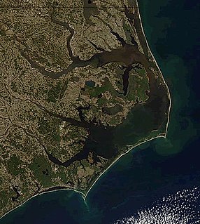
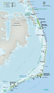
Cape Hatteras Light is a lighthouse located on Hatteras Island in the Outer Banks in the town of Buxton, North Carolina and is part of the Cape Hatteras National Seashore.

The Ponce de Leon Inlet Light is a lighthouse and museum located at Ponce de León Inlet in Central Florida. At 175 feet (53 m) in height, it is the tallest lighthouse in the state and one of the tallest in the United States. It is located between St. Augustine Light and Cape Canaveral Light. Restored by the Ponce de Leon Inlet Lighthouse Preservation Association, the lighthouse became a National Historic Landmark in 1998.

The Cape Lookout Lighthouse is a 163-foot high lighthouse located on the Southern Outer Banks of North Carolina. It flashes every 15 seconds and is visible at least 12 miles out to sea and up to 19 miles. The Cape Lookout Light is one of the very few lighthouses that operate during the day. It became fully automated in 1950. The Cape Lookout Lighthouse is the only such structure in the United States to bear the checkered daymark, intended not only for differentiation between similar light towers, but also to show direction. The center of the black diamonds points in a north-south direction, while the center of the white diamonds points east-west.

Goat Island Light is a lighthouse located off Cape Porpoise near Kennebunkport in southern Maine. Goat Island Light was established in 1835 to guard the entrance to Cape Porpoise Harbor. The original station was upgraded in 1859 to the current brick tower with a fifth order Fresnel lens. Keeper's quarters were added to the island in 1860. The light station was automated by the United States Coast Guard in 1990 and is currently active. The keepers dwellings and tower are leased to the Kennebunkport Conservation Trust. Goat Island Light can be seen from shore in Cape Porpoise Harbor just off State Route 9 north of Kennebunkport or is viewable by boat. The island is currently closed to the public except by special arrangement.

The Cape Hinchinbrook Light is a lighthouse located near the southern end of Hinchinbrook Island adjacent to Prince William Sound, in Alaska, United States.
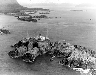
The Cape Spencer Light is a lighthouse in Alaska, United States, next to the entrance to Cross Sound and Icy Strait. The light is still an active aid to navigation. It is located on an islet in the southernmost end of Glacier Bay National Park and Preserve.

The Sentinel Island Light is a lighthouse in Alaska adjacent to Lynn Canal.

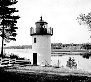
The Fort Point Light, or Fort Point Light Station, is located in Fort Point State Park, in Stockton Springs, Maine. A lighthouse at this point has served as an active aid to navigation since 1835; the present lighthouse dates to 1857, and is listed on the National Register of Historic Places.

The Cape Ann Light Station on Thacher Island, off Cape Ann in Rockport, Massachusetts, is nationally significant as the last light station to be established under colonial rule and the first station in the United States to mark a navigational hazard rather than a harbor entrance. The current pair of lighthouses were built in 1861. They were both equipped with first order Fresnel lenses, which stood approximately 10 feet (3.0 m) high and weighed several tons (tonnes).

Wood End Light Lookout Station is a historic lighthouse, located at the southwest end of Long Point in Provincetown, Massachusetts. It is located at Wood End, near the southernmost extent of the Provincetown Spit, and acts as a navigational aid to vessels on their approach to Provincetown Harbor. The Long Point Light Station, further down the peninsula at the tip of Long Point is an identical design and completed in 1875, three years after Wood End Light.
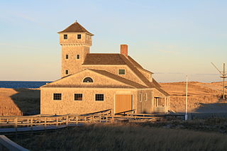
The Old Harbor U.S. Life Saving Station is a historic maritime rescue station and museum, located at Race Point Beach in Provincetown, Massachusetts. Built in 1897, it was originally located at Nauset Beach near the entrance to Chatham Harbor in Chatham, Massachusetts. It was used by the United States Life-Saving Service (USLSS), and then by its successor, the United States Coast Guard (USCG), as the Old Harbor Coast Guard Station. The station was decommissioned in 1944, abandoned and sold as surplus in 1947, and was used as a private residence for the next twenty-six years.

The Bodie Island Lifesaving Station, also known as the Bodie Island Coast Guard Station, is located on the Outer Banks of North Carolina at the southern end of Bodie Island, within Cape Hatteras National Seashore. The 10-acre (4.0 ha) district includes a residence, the lifesaving station, the Coast Guard station, and an observation tower, as well as a number of utility buildings. The facility was turned over to the National Park Service in 1953, with the establishment of the national seashore. The primary structure, the lifesaving station, was built in 1878, and was converted to a residence when the Coast Guard station was built in 1925. It was moved to its present location in 1955, as it was threatened by shoreline erosion. The Coast Guard station was altered the same year to provide housing and office space for the National Park Service.

The Hatteras Weather Bureau Station is a wood-frame building in Hatteras, North Carolina built in 1901 for what was then called the U.S. Weather Bureau. The then-remote location on the Outer Banks of North Carolina provided data on conditions in the Atlantic Ocean from a fixed location that was farther into the ocean environment than any on the Atlantic coast. The building served as a weather station from 1902 to 1946, when it was converted to living quarters for Weather Bureau personnel. In 1952 the property was turned over to the U.S. Coast Guard, which used it until 1958, when it was transferred to the National Park Service for use by Cape Hatteras National Seashore. From 1958 to 1976 the building was used as a research station, first by Duke University and later by North Carolina State University for investigations concerning marine invertebrates.
The Whitlocks Mill Light is a lighthouse on the south bank of the St. Croix River in Calais, Maine. It is the northernmost lighthouse in the state of Maine, and was the last light to be built in the state.

Egg Rock Light is a lighthouse on Frenchman Bay, Maine. Built in 1875, it is one of coastal Maine's architecturally unique lighthouses, with a square tower projecting through the square keeper's house. Located on Egg Rock, midway between Mount Desert Island and the Schoodic Peninsula, it is an active aid to navigation, flashing red every 40 seconds. The light was listed on the National Register of Historic Places as Egg Rock Light Station in 1988.

Hendricks Head Light is a lighthouse in Southport, Maine marking the west side of the mouth of the Sheepscot River. The light station was established in 1829, and its present structures date to 1875. It was deactivated in 1933, but relit in 1951. The two-story wood keeper's house is now a private summer residence. The light is on continuously, showing white to the west and red to the east. It was listed on the National Register of Historic Places as Hendricks Head Light Station on November 20, 1987.

Baker Island Light is a lighthouse on Baker Island, Maine, which is part of Acadia National Park. The light station was established in 1828 as a guide to the southern entrance to Frenchman Bay. The present tower was built in 1855; the well-preserved tower, keeper's house, and associated outbuildings were listed on the National Register of Historic Places in 1988.

The Nahant Life-Saving Station is a historic coastal rescue station at 96 Nahant Road in Nahant, Massachusetts. The station, which consists of a residence and an equipment building, was established in 1900 by the United States Life-Saving Service before being taken over by the United States Coast Guard in 1915. The station was discontinued in 1964, and the facilities were converted recreational use by the Coast Guard. In 1999 the 1.4 acres (0.57 ha) parcel was turned over to the Town of Nahant. The station, one of twelve such surviving facilities in the state, was listed on the National Register of Historic Places in 2012.

Cape Lookout Village Historic District is a national historic district located near Core Banks, Carteret County, North Carolina. It encompasses 20 contributing buildings 1 contributing site, and 6 contributing structures in Cape Lookout Village. The buildings include notable examples of Queen Anne and Bungalow / American Craftsman style architecture. The district includes two government complexes: the Cape Lookout Lighthouse Station and the Cape Lookout Coast Guard Station. In addition, 14 buildings, a long dock, and the circulation network, as well as the landscape in which these lie, compose the district. The buildings include the Life Saving Station (1888) and Boathouse, the Keeper's Quarters (1907), Luther Guthrie House, Gaskill-Guthrie House, Seifert-Davis House, Baker-Holderness House, the Bryant House, and the Carrie Arendell Davis House.

Oregon Inlet Station is a historic lifesaving station located near Rodanthe, Dare County, North Carolina. It was built in 1897 by the United States Life-Saving Service and remodeled in 1933 and 1970. It is a 1 1/2-story, Shingle Style rectangular frame building with a lookout tower. It has a porch that surrounds the building. It was one of seven lifesaving stations established on the Outer Banks of North Carolina in 1874, to serve the ships that were lost in the treacherous waters off the North Carolina coast.