
The Independent Subway System was a rapid transit rail system in New York City that is now part of the New York City Subway. It was first constructed as the Eighth Avenue Line in Manhattan in 1932. It was originally also known as the Independent City-Owned Subway System (ICOSS) or the Independent City-Owned Rapid Transit Railroad (ICORTR).

Crenshaw Boulevard is a north-south thoroughfare in Los Angeles, California, United States, that runs through Crenshaw and other neighborhoods along a 23-mile route in the west-central part of the city.
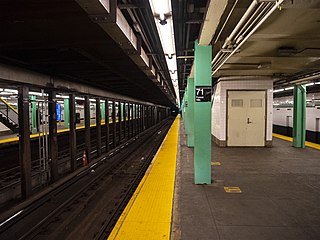
The Forest Hills–71st Avenue station is an express station on the IND Queens Boulevard Line of the New York City Subway, located on Queens Boulevard at 71st (Continental) Avenue in Forest Hills, Queens. It is served by the E and F trains at all times, the <F> train during rush hours in the reverse peak direction, and the R train at all times except late nights. It serves as the terminus for the latter service.
Central Expressway is a north–south highway in the Dallas-Fort Worth Metroplex in Texas (USA) and surrounding areas. The best-known section is the North Central Expressway, a name for a freeway section of U.S. Highway 75 between downtown Dallas and Van Alstyne, Texas. The southern terminus is south of the Woodall Rodgers Freeway at exit 284C of "hidden" Interstate 345. From there, Central Expressway becomes the South Central Expressway, the northernmost portion of which was renamed César Chávez Boulevard on April 9, 2010.

The 67th Avenue station is a local station on the IND Queens Boulevard Line of the New York City Subway. Located at the intersection of 67th Avenue and Queens Boulevard in Forest Hills, Queens, it is served by the R train at all times except nights, and the E and F trains during late nights.

The 63rd Drive–Rego Park station is a local station on the IND Queens Boulevard Line of the New York City Subway, consisting of four tracks. Located at 63rd Drive and Queens Boulevard in the Rego Park neighborhood of Queens, it is served by the R train at all times except nights, and the E and F trains at night.
Alameda Street is a major north-south thoroughfare in Los Angeles County, California. It is approximately 21 miles in length, running from Harry Bridges Boulevard in Wilmington; and through Carson, Compton, Lynwood, Watts, Florence-Graham, Huntington Park, Vernon and Arts District to Spring and College in Chinatown. For much of its length, Alameda runs through present and former industrial corridors, and is paralleled by Union Pacific Railroad tracks.

Marin Street station is a light rail station on the Muni Metro T Third Street line, located in the median of 3rd Street one block south of Cesar Chavez Street in the Bayview neighborhood of San Francisco, California. The station opened with the T Third Street line on April 7, 2007. It has two side platforms; the northbound platform is south of South Street, and the southbound platform north of Marin Street.
The Green Line is a 3.3 mi (5.3 km) METRORail light rail/streetcar line operated by METRO in Houston, Texas, serving the East End area. The first seven-station segment of this line opened on May 23, 2015. The two-station eastern end of this route was delayed due to issues over crossing Union Pacific Railroad tracks, but eventually opened in January 2017.
Soto Street is a major north-south thoroughfare in Los Angeles, California, connecting the southernmost neighborhoods of the Eastside, as well as the southeastern suburbs of Vernon and Huntington Park.

Cesar Chavez Avenue is a major east–west thoroughfare in Downtown Los Angeles, the Eastside and East Los Angeles, measuring 6.19 miles (9.96 km) in length. Named in honor of union leader César Chávez, the street was formed in 1994 from Sunset Boulevard between Figueroa and Main streets, a new portion of roadway, Macy Street between Main Street and Mission Road, and Brooklyn Avenue through Boyle Heights and East Los Angeles into Monterey Park. Much of the street is double-signed with its former names.

25th & Commercial station is a station on the Orange Line of the San Diego Trolley located in the Grant Hill neighborhood of San Diego, California. The stop is dedicated to Hispanic civil rights leader Cesar Chavez.

César E Chávez Boulevard is a street in Portland, Oregon, United States. Until 2009, it was known as Northeast and Southeast 39th Avenue.
Cesar Chavez (1927–1993) was an American farm worker, labor leader, and civil rights activist.

The Q11, Q21, Q52, and Q53 bus routes constitute a public transit corridor running along Woodhaven and Cross Bay Boulevards in Queens, New York City. The corridor extends primarily along the length of the two boulevards through "mainland" Queens, a distance of 6 miles (9.7 km) between Elmhurst and the Jamaica Bay shore in Howard Beach. The Q52 and Q53 buses, which provide Select Bus Service along the corridor, continue south across Jamaica Bay to the Rockaway peninsula, one of the few public transit options between the peninsula and the rest of the city.

Coffee Plant/Second Ward is a light rail station in Houston, Texas on the METRORail system. It is served by the Green Line and is located on Harrisburg Boulevard between York and Hutcheson streets. The station is named for the Second Ward neighborhood as well as a former Maxwell House coffee manufacturing plant. Maxwell House began operations at the plant in 1948 and sold the plant to Maximus Coffee Group in 2006, which operated the plant under the Atlantic Coffee Solutions brand until 2018.
Lockwood/Eastwood is a light rail station in Houston, Texas on the METRORail system. It is served by the Green Line and is located on Harrisburg Boulevard at Hagerman Street in the East End. The station is named for nearby Lockwood Drive as well as Eastwood Park.
Altic/Howard Hughes is a light rail station in Houston, Texas, on the METRORail system. It is served by the Green Line and is located on Harrisburg Boulevard at Altic Street in the East End. The station is named for Altic Street as well as Howard Hughes, who built a Hughes Tool Company factory in the area.
Magnolia Park Transit Center is a light rail and bus station in Houston, Texas on the METRORail system. It is the eastern terminus of the Green Line and is located on Harrisburg Boulevard at 70th Street in Magnolia Park, in the East End. Nearby the station are many restaurants and taquerias. The Magnolia Park shopping center is a half block down the street at Harrisburg and Sgt. Macario Garcia Drive.