
Gateway Arch National Park is an American national park located in St. Louis, Missouri, near the starting point of the Lewis and Clark Expedition.

The Katy Trail State Park is a state park in the U.S. state of Missouri that contains the Katy Trail, the country's longest continuous recreational rail trail. It runs 240 miles (390 km), largely along the northern bank of the Missouri River, in the right-of-way of the former Missouri–Kansas–Texas Railroad. Open year-round from sunrise to sunset, it serves hikers, joggers, and cyclists. Its hard, flat surface is of "limestone pug".

The Missouri State Capitol is the home of the Missouri General Assembly and the executive branch of government of the U.S. state of Missouri. Located in Jefferson City at 201 West Capitol Avenue, it is the third capitol to be built in the city. The domed building, designed by the New York City architectural firm of Tracy and Swartwout, was completed in 1917.

Washington State Park is a public recreation area covering 2,147 acres (869 ha) in Washington County in the central eastern part of the state of Missouri. It is located on Highway 21 about 14 miles (23 km) northeast of Potosi or 7 miles (11 km) southwest of DeSoto on the eastern edge of the Ozarks. The state park is noted for its Native American rock carvings and for its finely crafted stonework from the 1930s.
Battle of Athens State Historic Site is an historic battlefield and state park located in Clark County, Missouri, along the banks of the Des Moines River. It is the site of the Battle of Athens, fought in 1861 during the American Civil War. The site serves as an open-air museum interpreting the battle and its aftermath. It is one of the northernmost places in the state.

The Thomas Hart Benton Home and Studio State Historic Site is a state-owned property located at 3616 Belleview, Kansas City, Missouri, that preserves the house and studio of Missouri artist Thomas Hart Benton. The historic site was established in 1977 and is managed by the Missouri Department of Natural Resources. Tours are provided that show the furnished house and studio as Benton left it when he died on January 19, 1975. The site was listed on the National Register of Historic Places in 1980.
Nathan and Olive Boone Homestead State Historic Site, located two miles north of Ash Grove, Missouri, is a state-owned property that preserves the home built in 1837 by Nathan Boone, the youngest child of Daniel Boone. The Nathan Boone House, which was listed on the National Register of Historic Places in 1969, is a 1+1⁄2-story "classic" saddle-bag pioneer log house, constructed of hand-hewn oak log walls that rest on a stone foundation. Established in 1991, the historic site offers an interpretive trail plus tours of the home and cemetery.

Boone's Lick State Historic Site is located in Missouri, United States, four miles east of Arrow Rock. The park was established in 1960 around one of the saltwater springs that was used in the early 19th century. It was named after Nathan and Daniel Morgan Boone, sons of Daniel Boone, who produced salt from the springs. The springs lent their name to the Boone's Lick Country, the first major American settlement in Missouri, and the Boone's Lick Road, which traversed wilderness from St. Charles, Missouri to the boomtown of Franklin, Missouri, in the early 1800s.

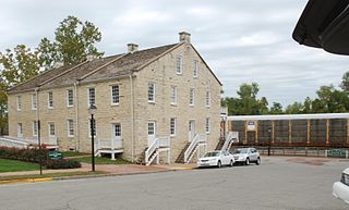
Missouri Mines State Historic Site occupies Federal Mill No. 3 in Park Hills, Missouri, United States, which processed the lead and zinc ore that was mined in the immediate area for many decades. The site's old power building features a geological and mining history museum and interpretive center focusing on the state's historic Old Lead Belt.

Graham Cave is a Native American archeological site near Mineola, Missouri in Montgomery County in the hills above the Loutre River. It is located in the 356 acre Graham Cave State Park. The entrance of the sandstone cave forms a broad arch 120 feet (37 m) wide and 16 feet (5 m) high. Extending about 100 feet (30 m) into the hillside, the cave protects an historically important Pre-Columbian archaeological site from the ancient Dalton and Archaic period dating back to as early as 10,000 years ago.

The Felix Vallé House State Historic Site is a state-owned historic preserve comprising the Felix Vallé House and other early 19th-century buildings in Ste. Genevieve, Missouri. It is managed by the Missouri Department of Natural Resources.
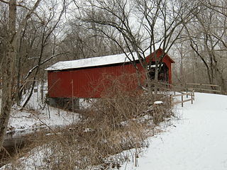
Sandy Creek Covered Bridge State Historic Site is a publicly owned property in Jefferson County, Missouri, administered by the Missouri Department of Natural Resources, preserving the Sandy Creek Covered Bridge. The bridge is one of four remaining covered bridges in Missouri, which once numbered about 30. It is a relatively rare example of a Howe truss bridge, one of three in Missouri. The covered bridge is named for Sandy Creek, which it crosses, and was added to the National Register of Historic Places in 1970.
Van Meter State Park is a public recreation area on the Missouri River in Saline County, Missouri. The state park consists of 1,105 acres (447 ha) of hills, ravines, fresh water marsh, fens, and bottomland and upland forests in an area known as "the Pinnacles." The park has several archaeological sites, a cultural center, and facilities for camping, hiking, and fishing. It is managed by the Missouri Department of Natural Resources.

Gov. Daniel Dunklin's Grave is a Missouri state park at Herculaneum, Missouri, preserving the gravesite of Daniel Dunklin, who was governor of Missouri during the mid-1830s. Dunklin died in 1844 and was buried on his family estate, but was reinterred in 1885 when most of the estate he was buried on was sold. In 1965, the state of Missouri took control of the site to serve as a memorial to Dunklin, who is credited as the father of Missouri's public education system. The site covers 1.37 acres (0.55 ha) and is operated by the Missouri Department of Natural Resources. The cemetery is surrounded by limestone walls and overlooks the Mississippi River.
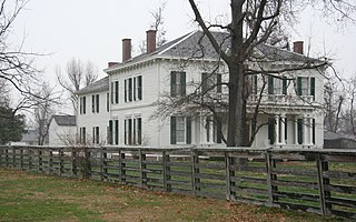
The Hunter-Dawson State Historic Site is a state-owned property in New Madrid, Missouri, maintained by the Missouri Department of Natural Resources as a historic house museum and state historic site. The Hunter-Dawson House was added to the National Register of Historic Places in 2012.
The Iliniwek Village State Historic Site is a state-owned property in Clark County, Missouri, maintained by the Missouri Department of Natural Resources, preserving the only known Illinois Indian village discovered in Missouri.
Jefferson Landing State Historic Site is a historic district maintained by the Missouri Department of Natural Resources encompassing several state-owned properties in Jefferson City, Missouri, United States. The historic site includes the Christopher Maus House, the Union Hotel, and the Lohman's Landing Building, which was listed on the National Register of Historic Places in 1969.
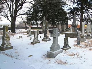
Jewell Cemetery State Historic Site is a publicly owned property in Columbia, Missouri, maintained as a state historic site by the Missouri Department of Natural Resources. Among the notable persons buried in the cemetery, which holds the remains of more than 40 descendants of George A. Jewell, are Missouri governor Charles Henry Hardin and the educator William Jewell. The property became part of the state parks system in 1970.

Lewis and Clark State Park is a public recreation area occupying 189 acres (76 ha) on the south shore of 365-acre (148 ha) Lewis and Clark Lake in Buchanan County, Missouri. The state park features camping, picnicking, and fishing.

