
John Alden Sr. was a crew member on the historic 1620 voyage of the Pilgrim ship Mayflower. Rather than return to England with the ship, he stayed and became a blacksmith at what became Plymouth Colony. He was hired in Southhampton, England, as the ship's cooper, responsible for maintaining the ship's barrels. He was a signatory to the Mayflower Compact. He married fellow Mayflower passenger Priscilla Mullins, whose entire family perished in the first winter.
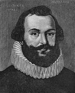
Myles Standish was an English military officer hired by the Pilgrims as military adviser for Plymouth Colony. He accompanied them on the Mayflower journey and played a leading role in the administration and defense of Plymouth Colony from its inception. On February 17, 1621, the Plymouth Colony militia elected him as its first commander and continued to re-elect him to that position for the remainder of his life. He served as an agent of Plymouth Colony in England, as assistant governor, and as treasurer of the Colony. He was also one of the first settlers and founders of the town of Duxbury, Massachusetts.

Plymouth Colony was an English colonial venture in America from 1620 to 1691 at a location that had previously been surveyed and named by Captain John Smith. The settlement served as the capital of the colony and developed as the town of Plymouth, Massachusetts. At its height, Plymouth Colony occupied most of the southeastern portion of Massachusetts.

Duxbury is a historic seaside town in Plymouth County, Massachusetts, United States. A suburb located on the South Shore approximately 35 miles (56 km) to the southeast of Boston, the population was 15,059 at the 2010 census.

Plymouth is a town in Plymouth County, Massachusetts. The town holds a place of great prominence in American history, folklore, and culture, and is known as "America's Hometown." Plymouth was the site of the colony founded in 1620 by the Mayflower Pilgrims, where New England was first established. It is the oldest municipality in New England and one of the oldest in the United States. The town has served as the location of several prominent events, one of the more notable being the First Thanksgiving feast. Plymouth served as the capital of Plymouth Colony from its founding in 1620 until the colony's merger with the Massachusetts Bay Colony in 1691. It is named after Plymouth, England where the Mayflower set sail for America.

Massasoit Sachem or Ousamequin was the sachem or leader of the Wampanoag confederacy. The term Massasoit means Great Sachem.

William Brewster was an English official and Mayflower passenger in 1620. In Plymouth Colony, by virtue of his education and existing stature with those immigrating from the Netherlands, Brewster, a Brownist, became senior elder and the leader of the community.
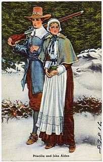
Priscilla Alden was a noted member of Massachusetts's Plymouth Colony of Pilgrims and the wife of fellow colonist John Alden. They married in 1621 in Plymouth.

Duxbury Beach is a beach in the town of Duxbury, Massachusetts. It is six miles long and is accessed by the Powder Point Bridge from Duxbury, or Gurnet Road from Marshfield. Approximately 4.5 miles of the beach is owned by Duxbury Beach Reservation, Inc, which leases a portion of the beach out to the town of Duxbury on a yearly basis, under the circumstances that the town of Duxbury provides Harbormasters to police the area.
Plymouth Harbor is a harbor located in Plymouth, a town in the South Shore region of the U.S. state of Massachusetts. It is part of the larger Plymouth Bay. Historically, Plymouth Harbor was the site of anchorage of the Mayflower where the Plymouth Colony pilgrims disembarked to establish a permanent settlement at Plymouth.

Plymouth Bay is a small, well-protected bay of the Atlantic Ocean on the western shore of larger Cape Cod Bay along the coastline of the Commonwealth of Massachusetts. Plymouth Bay retains historical significance for the landing at Plymouth Rock in 1620 by the Pilgrims aboard the Mayflower who proceeded to establish the first permanent Northern European settlement in North America at Plymouth Colony.

There are several neighborhoods in Plymouth, Massachusetts. With a total area of 134.0 mi², Plymouth is the largest municipality in Massachusetts by area. In addition, with a population of 51,701 at the 2000 census and an estimated population of 57,901 in 2007, Plymouth is the second-largest town in the state by population (after Framingham. As such, Plymouth is home to many distinct neighborhoods and geographical locations.

Plymouth Beach is a small village located in Plymouth, Massachusetts, United States. It is located directly south of Plymouth Center, and is adjacent to Plimoth Plantation. Plymouth Beach consists of a motel, a restaurant and a small beachside community along Warren Cove.

Warren Cove is an exclusive oceanfront residential area Plymouth Bay in Plymouth, Massachusetts. Plymouth Beach and Rocky Point surround the southern edge of the cove. Stately homes along Warren Avenue have a commanding view of Plymouth Long Beach, Gurnet Light, Duxbury Bay, "Bug Light", Saquish, and Kingston Shores.
Gurnet Point, also known as The Gurnet, is located at the end of the peninsula at the entrance to Plymouth Bay in Plymouth, Massachusetts, and is a headland and the small private settlement located on it. The Pilgrims who settled Plymouth in 1620 named it Gurnett’s Nose for its resemblance to headlands in the English Channel where gurnett fish were plentiful. The Gurnet is the home of Plymouth (Gurnet) Lighthouse as well as of Fort Andrew from the Revolutionary War. Its access by land is either from Gurnet Road in Marshfield or from the Powder Point Bridge at Duxbury Beach 5 miles to the north by foot or by 4-wheel drive beach buggies, but access is restricted to property owners, residents and their guests, except for once a year on Memorial Day when the lighthouse is open to the public.

Duxbury Bay is a bay on the coast of Massachusetts in the United States. The west shore of the bay is the town of Duxbury, Massachusetts; and the bay is formed by a sandbar called The Gurnet extending southeasterly from Marshfield, Massachusetts into Cape Cod Bay. The town of Marshfield was named for the estuarine wetland at the north end of the bay. The bay opens southerly toward Plymouth, Massachusetts between Captains Hill to the west and Saquish Head to the east.

The Myles Standish Burial Ground in Duxbury, Massachusetts is, according to the American Cemetery Association, the oldest maintained cemetery in the United States.
Elder Love Brewster was an early American settler, the son of Elder William Brewster and his wife, Mary Brewster. He traveled with his father, mother and brother, Wrestling, on the Mayflower reaching what became the Plymouth Colony in Massachusetts in 1620. Brewster had two sisters, Patience and Fear, and two brothers, Jonathan and Wrestling, along with an unnamed sister who died young. He was a founder of the town of Bridgewater, Plymouth County, Massachusetts.
Saquish Beach, sometimes simply referred to as Saquish, is a beach and headland located at the end of the peninsula at the entrance to Plymouth Bay in Plymouth, Massachusetts. A small private settlement of summer cottages line the beach and headland, sometimes referred to as Saquish Neck and Saquish Head respectively. It is located east of Clark's Island and west of Gurnet Point. Its only access by land is from the Powder Point Bridge at Duxbury Beach, 5 miles to the north by foot or by 4-wheel drive beach buggies. As a private beach, access is restricted to property owners, residents, and their guests.
Mayflower Cemetery is a town-owned cemetery in Duxbury, in Plymouth County, Massachusetts. The first grave was of Stephen Russell in 1787 and the first engraved stone was of Ichabod Sampson in 1788. The Duxbury Crematory, also owned by the town, is located on the cemetery grounds. The cemetery is also known as the "Old Cemetery at Unitarian Church Duxbury."

