Barnstable County is a county located in the U.S. state of Massachusetts. As of the 2010 census, the population was 215,888. Its county seat is Barnstable. The county consists of Cape Cod and associated islands.
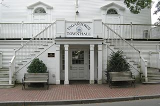
Dukes County is a county located in the U.S. state of Massachusetts. As of the 2010 census, the population was 16,535, making it the second-least populous county in Massachusetts. Its county seat is Edgartown.
Gosnold is a town that encompasses the Elizabeth Islands in Dukes County, Massachusetts, United States. At the 2010 census, the town population was 75, making it the least populous town in Massachusetts. Most of the residents live in the village of Cuttyhunk, while most of the land in the town is owned by the Forbes family.

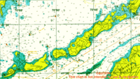
The Elizabeth Islands are a chain of small islands extending southwest from the southern coast of Cape Cod, Massachusetts in the United States. They are located at the outer edge of Buzzards Bay, north of Martha's Vineyard, from which they are separated by Vineyard Sound, and constitute the town of Gosnold in Dukes County, Massachusetts.
Green Island, also known as North Brewster Island, is a rocky outer island in the Boston Harbor Islands National Recreation Area, to the north of Calf Island and Hypocrite Channel. The island has a permanent size of 2.5 acres (10,000 m2), plus an intertidal zone of a further 15 acres (61,000 m2), and is exposed from the east and northeast with little soil or plant life. The island is named after Joseph Green, a well-known merchant, who owned the island during Colonial times.

Nomans Land, is an uninhabited island 612 acres (2.48 km2) in size, located in the town of Chilmark, Dukes County, Massachusetts. It is situated about 3 miles (4.8 km) off the southwest corner of the island of Martha's Vineyard.

Cuttyhunk Island is the outermost of the Elizabeth Islands in Massachusetts. A small outpost for the harvesting of sassafras was occupied for a few weeks in 1602, arguably making it the first English settlement in New England. Cuttyhunk is located between Buzzards Bay to the north and Vineyard Sound to the south. Penikese Island and Nashawena Island are located to the north and east respectively.

Buzzards Bay is a bay of the Atlantic Ocean adjacent to the U.S. state of Massachusetts. It is approximately 28 miles long by 8 miles wide. It is a popular destination for fishing, boating, and tourism. Since 1914, Buzzards Bay has been connected to Cape Cod Bay by the Cape Cod Canal. In 1988, under the Clean Water Act, the Environmental Protection Agency and the State of Massachusetts designated Buzzards Bay to the National Estuary Program, as "an estuary of national significance" that is threatened by pollution, land development, or overuse.
The Graves is an aggregation of rock outcroppings in Massachusetts Bay, Massachusetts, United States. Situated some 11 miles (18 km) offshore of downtown Boston, it is the outermost island in the Boston Harbor Islands National Recreation Area.
Adams Island was an island in the U.S. state of Massachusetts.

Nonamesset Island is the most easterly of the Elizabeth Islands of Dukes County, Massachusetts, United States. The island has a land area of 1.398 km² and was uninhabited as of the 2000 census. The island is part of the town of Gosnold, Massachusetts.

Pasque Island is one of the Elizabeth Islands of Dukes County, Massachusetts, United States. It lies between Nashawena Island to the west and Naushon Island to the east. The island has a land area of 3.45 km² and had a population of 2 persons as of the 2000 census. The island is part of the town of Gosnold, Massachusetts.
Uncatena Island is one of the Elizabeth Islands of Dukes County, Massachusetts, United States. It is the most northerly of the Elizabeth Islands and lies just off the northernmost point of Naushon Island. Uncatena has a land area of 0.492 km², and was uninhabited as of the 2000 census. It is part of the Town of Gosnold.
Veckatimest Island is one of the Elizabeth Islands, part of the town of Gosnold in Dukes County, Massachusetts, United States. The island has a land area of 0.0675 km² and was uninhabited as of the 2000 census.
Nashawena Island is the second largest of the Elizabeth Islands of Dukes County, Massachusetts, United States. It lies between Cuttyhunk Island to the west and Pasque Island to the east. The island has a land area of 7.076 km² and an official permanent population of 2 persons as of the 2000 U.S. Census. The island is part of the town of Gosnold, Massachusetts. Nashawena is an Indian word meaning "middle island". Rock Island and Baret Island are two small islands located north of Nashawena.

Outer Brewster Island, also known as Outward Island, is one of the outer islands in the Boston Harbor Islands National Recreation Area and is situated some 10 miles offshore of downtown Boston. The island has a permanent size of 20 acres, and consists of exposed bedrock covered by fertile soil bounded by a rocky shore with steep cliffs. It provides a nesting habitat for coastal water birds, including cormorants, gulls, common eider ducks, glossy ibis and American oystercatchers. The birds are aggressive during their nesting season and access by humans, which is by private boat only, is discouraged during this period.

SS James Longstreet was a Liberty ship built in the United States during World War II. Named after the Confederate general James Longstreet, she entered service in 1942, but was wrecked in a storm on 26 October 1943 and was subsequently used as a target hulk by the United States Navy.
Fish Island is an island in the U.S. state of Massachusetts. The island is located in the Acushnet River and within the city of New Bedford.
Weepecket Island Bomb Area was a former naval bomb area for aviators, located on the Weepecket Islands, in Gosnold, Massachusetts.

The Middleborough Historical Museum is a museum located at 18 Jackson Street, Middleborough, Massachusetts, and maintained by the Middleborough Historical Association. It is sometimes known as the Tom Thumb Museum for its extensive holdings of personal items from General Tom Thumb and his wife Lavinia Warren, who lived in the nearby Tom Thumb House. The museum was founded in 1961, and currently comprises 7 buildings as follows: