
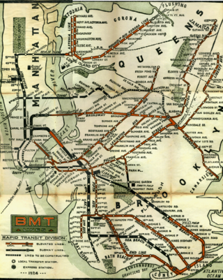
The Q Second Avenue/Broadway Express/Brighton Local is a rapid transit service in the B Division of the New York City Subway. Its route emblem, or "bullet", is colored yellow since it uses the BMT Broadway Line in Manhattan.
The BMT Brighton Line, also known as the Brighton Beach Line, is a rapid transit line in the B Division of the New York City Subway in Brooklyn, New York City, United States. Local service is provided at all times by the Q train, but is joined by the B express train on weekdays. The Q train runs the length of the entire line from Coney Island–Stillwell Avenue to the Manhattan Bridge south tracks. The B begins at Brighton Beach and runs via the bridge's north tracks.
The Franklin Avenue station is a station complex shared by the BMT Franklin Avenue Line and the IND Fulton Street Line of the New York City Subway, located at Franklin Avenue and Fulton Street in Bedford–Stuyvesant, Brooklyn. It is served by the:

Downtown Brooklyn is the third largest central business district in New York City, and is located in the northwestern section of the borough of Brooklyn. The neighborhood is known for its office and residential buildings, such as the Williamsburgh Savings Bank Tower and the MetroTech Center office complex.
The BMT Jamaica Line, also known as the Broadway - Brooklyn Line is an elevated rapid transit line of the B Division of the New York City Subway, in Brooklyn and Queens, New York City, United States. It runs from the Williamsburg Bridge southeast over Broadway to East New York, Brooklyn, and then east over Fulton Street and Jamaica Avenue to Jamaica, Queens. In western Jamaica, the line goes into a tunnel, becoming the lower level of the Archer Avenue lines in central Jamaica. The J and Z trains serve the entire length of the Jamaica Line, and the M serves the line west of Myrtle Avenue.
The BMT Lexington Avenue Line was the first standard elevated railway in Brooklyn, New York, operated in its later days by the Brooklyn Rapid Transit Company, the Brooklyn–Manhattan Transit Corporation, and then the City of New York.
The Nassau Street Loop, also called the Nassau Loop, was a service pattern of the Brooklyn–Manhattan Transit Corporation (BMT) inaugurated in 1931 when the BMT Nassau Street Line was completed, providing a physical link that allowed a train to originate in Brooklyn, run through Lower Manhattan and return to Brooklyn without having to terminate and reverse the direction of the train. Nassau Loop services have not been able to operate since 1967, when the Loop line's connection to the Manhattan Bridge was severed.

The Park Row station was a major elevated railway terminal constructed on the Manhattan side of the Brooklyn Bridge, across from New York City Hall and the IRT’s elevated City Hall station. It served as the terminal for BMT services operating over the Brooklyn Bridge Elevated Line from the BMT Fulton Street Line, BMT Myrtle Avenue Line and their feeders. Until the opening of the nearby Williamsburg Bridge to elevated train traffic in 1913, it was the only Manhattan station available for elevated trains from Brooklyn, and the only elevated station in Manhattan to be owned by a company other than the IRT or its predecessors.

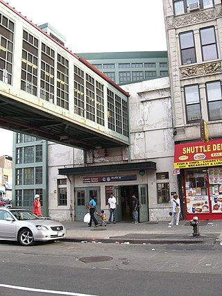
The BMT Franklin Avenue Line is a rapid transit line of the New York City Subway in Brooklyn, New York, running between Franklin Avenue and Prospect Park. Service is full-time, and provided by the Franklin Avenue Shuttle. The line serves the neighborhoods of Bedford-Stuyvesant and Crown Heights, and allows for easy connections between the Fulton Street Line and the Brighton Line.

The Newkirk Plaza station is an express station on the BMT Brighton Line of the New York City Subway in Flatbush, Brooklyn. It is located on an open-cut at the center of the pedestrian-only Newkirk Plaza shopping mall, which is bounded by Newkirk Avenue on the north, Foster Avenue on the south, Marlborough Road to the west, and East 16th Street to the east. The station is served by the Q train at all times and by the B train on weekdays only.

The High Street station, also signed as High Street–Brooklyn Bridge, and also referred to as Brooklyn Bridge Plaza and Cranberry Street, is a station on the IND Eighth Avenue Line of the New York City Subway. It is located at Cadman Plaza East near Red Cross Place and the Brooklyn Bridge approach in Brooklyn Heights, Brooklyn. Its name comes from older street names; its original location was at the intersection of High Street and Washington Street. It is served by the A train at all times and the C train at all times except late nights.

Cadman Plaza is a park located on the border of the Brooklyn Heights and Downtown Brooklyn neighborhoods in Brooklyn, New York City. Named for Reverend Doctor Samuel Parkes Cadman (1864–1936), a renowned minister in the Brooklyn Congregational Church, it is built on land reclaimed by condemnation in 1935 and was named as a park in 1939. The park borders Cadman Plaza West and Cadman Plaza East and the west and east sides of the plaza, respectively.

The B54 is a bus route on Myrtle Avenue in Brooklyn, New York City. The line travels between Downtown Brooklyn in the west and Myrtle–Wyckoff Avenues station in the east. The B54 operates from MTA New York City Bus's Fresh Pond Depot in Ridgewood, Queens. The route serves only the section of Myrtle Avenue within Brooklyn; the section within Queens is served by the Q55 bus.

The Fulton Street Line, also called the Fulton Street Elevated or Kings County Line, was an elevated rail line mostly in Brooklyn, New York City, United States. It ran above Fulton Street from Fulton Ferry, Brooklyn in Downtown Brooklyn east to East New York, and then south on Van Sinderen Avenue (southbound) and Snediker Avenue (northbound), east on Pitkin Avenue, north on Euclid Avenue, and east on Liberty Avenue to Ozone Park, Queens.
Sands Street was a station on the demolished BMT Myrtle Avenue Line. It was a large complex with two levels.
Court Street – Myrtle Avenue was a station on the demolished BMT Fulton Street Line. The Fulton Street Elevated was built by the Kings County Elevated Railway Company and this station started service on April 24, 1888. The station had 2 tracks and 2 side platforms. Eastbound trains would stop at Court Street, while westbound trains would stop at Myrtle Avenue. It was served by trains of the BMT Fulton Street Line, and until 1920, trains of the BMT Brighton Line. This station was served by steam locomotives between 1888 and 1899. In 1898, the Brooklyn Rapid Transit Company (BRT) absorbed the Kings County Elevated Railway, and it took over the Fulton Street El, and it was electrified on July 3, 1899. It also had a connection to the streetcar line of the same name. It closed on June 1, 1940, when all service from Fulton Ferry and Park Row to Rockaway Avenue was abandoned, as it came under city ownership.
Flatbush Avenue was a station on the demolished BMT Fulton Street Line. The Fulton Street Elevated was built by the Kings County Elevated Railway Company and this station started service on April 24, 1888. The station had 2 tracks and 1 island platform. It was served by trains of the BMT Fulton Street Line, and until 1920, trains of the BMT Brighton Line. The station was located west of the BMT Fifth Avenue Line, but had no connection to that elevated line. It was also located north of the Flatbush Avenue station on the Long Island Rail Road, now known as the Atlantic Terminal, and had no connections there either. This station was served by steam locomotives between 1888 and 1899. In 1898, the Brooklyn Rapid Transit Company (BRT) absorbed the Kings County Elevated Railway, and it took over the Fulton Street El, and it was electrified on July 3, 1899. It closed on June 1, 1940, when all service from Fulton Ferry and Park Row to Rockaway Avenue was abandoned, as it came under city ownership. Current mass transit stations available nearby are either at Nevins Street subway station on the IRT Eastern Parkway Line to the southeast, or at DeKalb Avenue subway station on the BMT Fourth Avenue and Brighton Lines to the northwest.
Lafayette Avenue was a station on the demolished BMT Fulton Street Line. The Fulton Street Elevated was built by the Kings County Elevated Railway Company and this station started service on April 24, 1888. The station had 2 tracks and 1 island platform. It was served by trains of the BMT Fulton Street Line, and until 1920, trains of the BMT Brighton Line. The station was located east of the BMT Fifth Avenue Line, but had no connection to that elevated line. It was also located north of the Flatbush Avenue station of the Long Island Rail Road, now known as the Atlantic Terminal, and had no connections there either. This station was served by steam locomotives between 1888 and 1899. In 1898, the Brooklyn Rapid Transit Company (BRT) absorbed the Kings County Elevated Railway, and it took over the Fulton Street El, and it was electrified on July 3, 1899. It closed on June 1, 1940, when all service from Fulton Ferry and Park Row to Rockaway Avenue was abandoned, as it came under city ownership. Thought the Fulton Street subway became the replacement for the Fulton Street Elevated, the closest station to the site of Lafayette Avenue station is actually Fulton Street station on the IND Crosstown Line.


