In petroleum exploration and development, formation evaluation is used to determine the ability of a borehole to produce petroleum. Essentially, it is the process of "recognizing a commercial well when you drill one".

An ice core is a core sample that is typically removed from an ice sheet or a high mountain glacier. Since the ice forms from the incremental buildup of annual layers of snow, lower layers are older than upper, and an ice core contains ice formed over a range of years. Cores are drilled with hand augers or powered drills; they can reach depths of over two miles (3.2 km), and contain ice up to 800,000 years old.

Drill bits are cutting tools used to remove material to create holes, almost always of circular cross-section. Drill bits come in many sizes and shapes and can create different kinds of holes in many different materials. In order to create holes drill bits are usually attached to a drill, which powers them to cut through the workpiece, typically by rotation. The drill will grasp the upper end of a bit called the shank in the chuck.
Well logging, also known as borehole logging is the practice of making a detailed record of the geologic formations penetrated by a borehole. The log may be based either on visual inspection of samples brought to the surface or on physical measurements made by instruments lowered into the hole. Some types of geophysical well logs can be done during any phase of a well's history: drilling, completing, producing, or abandoning. Well logging is performed in boreholes drilled for the oil and gas, groundwater, mineral and geothermal exploration, as well as part of environmental and geotechnical studies.

A drilling rig is an integrated system that drills wells, such as oil or water wells, in the earth's subsurface. Drilling rigs can be massive structures housing equipment used to drill water wells, oil wells, or natural gas extraction wells, or they can be small enough to be moved manually by one person and such are called augers. Drilling rigs can sample subsurface mineral deposits, test rock, soil and groundwater physical properties, and also can be used to install sub-surface fabrications, such as underground utilities, instrumentation, tunnels or wells. Drilling rigs can be mobile equipment mounted on trucks, tracks or trailers, or more permanent land or marine-based structures. The term "rig" therefore generally refers to the complex equipment that is used to penetrate the surface of the Earth's crust.

A core sample is a cylindrical section of (usually) a naturally-occurring substance. Most core samples are obtained by drilling with special drills into the substance, such as sediment or rock, with a hollow steel tube, called a core drill. The hole made for the core sample is called the "core hole". A variety of core samplers exist to sample different media under different conditions. More continue to be invented on a regular basis. In the coring process, the sample is pushed more or less intact into the tube. Removed from the tube in the laboratory, it is inspected and analyzed by different techniques and equipment depending on the type of data desired.

The Index to Marine & Lacustrine Geological Samples is a collaboration between twenty institutions and agencies that operate geological sample repositories. The purpose of the database is to help researchers locate sea floor and lakebed cores, grabs, dredges, and drill samples in their collections.

In geotechnical engineering, drilling fluid, also called drilling mud, is used to aid the drilling of boreholes into the earth. Often used while drilling oil and natural gas wells and on exploration drilling rigs, drilling fluids are also used for much simpler boreholes, such as water wells. One of the functions of drilling mud is to carry cuttings out of the hole.
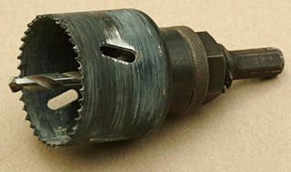
A hole saw, also known as a hole cutter, is a saw blade of annular (ring) shape, whose annular kerf creates a hole in the workpiece without having to cut up the core material. It is used in a drill. Hole saws typically have a pilot drill bit (arbor) at their center to keep the saw teeth from walking. The fact that a hole saw creates the hole without needing to cut up the core often makes it preferable to twist drills or spade drills for relatively large holes. The same hole can be made faster and using less power.
Mud logging is the creation of a detailed record of a borehole by examining the cuttings of rock brought to the surface by the circulating drilling medium. Mud logging is usually performed by a third-party mud logging company. This provides well owners and producers with information about the lithology and fluid content of the borehole while drilling. Historically it is the earliest type of well log. Under some circumstances compressed air is employed as a circulating fluid, rather than mud. Although most commonly used in petroleum exploration, mud logging is also sometimes used when drilling water wells and in other mineral exploration, where drilling fluid is the circulating medium used to lift cuttings out of the hole. In hydrocarbon exploration, hydrocarbon surface gas detectors record the level of natural gas brought up in the mud. A mobile laboratory is situated by the mud logging company near the drilling rig or on deck of an offshore drilling rig, or on a drill ship.

Drill cuttings are broken bits of solid material removed from a borehole drilled by rotary, percussion, or auger methods and brought to the surface in the drilling mud. Boreholes drilled in this way include oil or gas wells, water wells, and holes drilled for geotechnical investigations or mineral exploration.
The Denver Federal Center, in Lakewood, Colorado, is part of the General Services Administration and is home to about 6,200 employees of agencies of the federal government of the United States. The Center encompasses an area of about 670 acres (2.7 km2) and has 90 buildings with over 4,000,000 square feet (400,000 m2) of office, warehouse, lab and special use space. There are 28 different Federal agencies on-site, making it the largest concentration of Federal agencies outside of Washington, D.C.
The Mineral Core Research Facility (MCRF) is run by the Alberta Geological Survey (AGS) and assists the Alberta government's Department of Energy in administering the Metallic and Industrial Minerals Regulations of the Mines and Minerals Act for the Province of Alberta. Under these regulations, the Crown collects mineral core and rock samples from companies working on mineral permits and makes these materials publicly available for use by prospectors, mineral exploration companies and academia for mineral exploration and research purposes.

Nintoku Seamount or Nintoku Guyot is a seamount and guyot in the Hawaiian-Emperor seamount chain. It is a large, irregularly shaped volcano that last erupted 66 million years ago. Three lava flows have been sampled at Nintoku Seamount; the flows are almost all alkalic (subaerial) lava. It is 56.2 million years old.

Boring is drilling a hole, tunnel, or well in the earth. It is used for various applications in geology, agriculture, hydrology, civil engineering, and mineral exploration. Today, most earth drilling serves one of the following purposes:

The Lunar Sample Laboratory Facility (LSLF) is a repository and laboratory facility at NASA's Lyndon B. Johnson Space Center in Houston, Texas, opened in 1979 to house geologic samples returned from the Moon by the Apollo program missions to the lunar surface between 1969 and 1972. The facility preserves most of the 382 kilograms (842 lb) of lunar material returned over the course of Apollo program and other extraterrestrial samples, along with associated data records. It also contains laboratories for processing and studying the samples without contamination.

The Wattenberg Gas Field is a large producing area of natural gas and condensate in the Denver Basin of central Colorado, USA. Discovered in 1970, the field was one of the first places where massive hydraulic fracturing was performed routinely and successfully on thousands of wells. The field now covers more than 2,000 square miles between the cities of Denver and Greeley, and includes more than 23,000 wells producing from a number of Cretaceous formations. The bulk of the field is in Weld County, but it extends into Adams, Boulder, Broomfield, Denver, and Larimer Counties.
Deep hole drilling (DHD) is a residual stress measurement technique used to measure locked-in and applied stresses in engineering materials and components. DHD is a semi-destructive mechanical strain relaxation (MSR) technique, which seeks to measure the distribution of stresses along the axis of a drilled reference hole. The process is unique in its ability to measure residual stresses at a microscopic level with a penetration of over 750 millimetres (30 in), without total destruction of the original component. DHD is considered deep in comparison to other hole drilling techniques such as centre hole drilling.

Ice drilling allows scientists studying glaciers and ice sheets to gain access to what is beneath the ice, to take measurements along the interior of the ice, and to retrieve samples. Instruments can be placed in the drilled holes to record temperature, pressure, speed, direction of movement, and for other scientific research, such as neutrino detection.


