
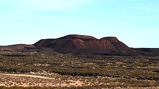
The Mono–Inyo Craters are a volcanic chain of craters, domes and lava flows in Mono County, Eastern California. The chain stretches 25 miles (40 km) from the northwest shore of Mono Lake to the south of Mammoth Mountain. The Mono Lake Volcanic Field forms the northernmost part of the chain and consists of two volcanic islands in the lake and one cinder cone volcano on its northwest shore. Most of the Mono Craters, which make up the bulk of the northern part of the Mono–Inyo chain, are phreatic volcanoes that have since been either plugged or over-topped by rhyolite domes and lava flows. The Inyo Craters form much of the southern part of the chain and consist of phreatic explosion pits, and rhyolitic lava flows and domes. The southernmost part of the chain consists of fumaroles and explosion pits on Mammoth Mountain and a set of cinder cones south of the mountain; the latter are called the Red Cones.

The geology of the Lassen volcanic area presents a record of sedimentation and volcanic activity in the area in and around Lassen Volcanic National Park in Northern California, U.S. The park is located in the southernmost part of the Cascade Mountain Range in the Pacific Northwest region of the United States. Pacific Oceanic tectonic plates have plunged below the North American Plate in this part of North America for hundreds of millions of years. Heat from these subducting plates has fed scores of volcanoes in California, Oregon, Washington and British Columbia over at least the past 30 million years and is also responsible for activities in the Lassen volcanic area.

Mount Thielsen, or Big Cowhorn, is an extinct shield volcano in the Oregon High Cascades, near Mount Bailey. Because eruptive activity ceased 250,000 years ago, glaciers have heavily eroded the volcano's structure, creating precipitous slopes and a horn-like peak. The spire-like shape of Thielsen attracts lightning strikes and creates fulgurite, an unusual mineral. The prominent horn forms a centerpiece for the Mount Thielsen Wilderness, a reserve for recreational activities such as skiing and hiking.

Mount Washington is a deeply eroded volcano in the Cascade Range of Oregon. It lies within Deschutes and Linn counties and is surrounded by the Mount Washington Wilderness area.

Belknap Crater is a shield volcano in the Cascade Range in the U.S. state of Oregon. Located in Linn County, it is associated with lava fields and numerous subfeatures including the Little Belknap and South Belknap volcanic cones. It lies north of McKenzie Pass and forms part of the Mount Washington Wilderness. Belknap is not forested and most of its lava flows are not vegetated, though there is some wildlife in the area around the volcano, as well as a number of tree molds formed by its eruptive activity.

Indian Heaven is a volcanic field in Skamania County in the state of Washington, in the United States. Midway between Mount St. Helens and Mount Adams, the field dates from the Pleistocene to the early Holocene epoch. It trends north to south and is dominated by six small shield volcanoes; these shields are topped by small spatter and cinder cones, and the field includes a number of subglacial volcanoes and tuyas. The northernmost peak in the field is Sawtooth Mountain and the southernmost is Red Mountain; its highest point is Lemei Rock at an elevation of 5,925 feet (1,806 m).
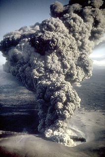
A maar is a broad, low-relief volcanic crater caused by a phreatomagmatic eruption. A maar characteristically fills with water to form a relatively shallow crater lake which may also be called a maar. The name comes from a Moselle Franconian dialect word used for the circular lakes of the Daun area of Germany. Maars are shallow, flat-floored craters that scientists interpret as having formed above diatremes as a result of a violent expansion of magmatic gas or steam; deep erosion of a maar presumably would expose a diatreme. Maars range in size from 60 to 8,000 m across and from 10 to 200 m deep; most maars commonly fill with water to form natural lakes. Most maars have low rims composed of a mixture of loose fragments of volcanic rocks and rocks torn from the walls of the diatreme.
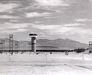
Jackass Flats is a shallow alluvial basin located in the southwest portion of the Nevada National Security Site in Nye County, Nevada. The area lies east of Yucca Mountain, south of the Calico Hills and Shoshone Mountain and northwest of Skull Mountain. The valley drains to the southwest via the Tonopah and Fortymile washes into the Amargosa Valley across US Route 95 at the town of Amargosa Valley, Nevada. The "flat" covers an area of approximately 120 square miles (310 km2) and ranges in elevation from about 2,800 ft (850 m) just north of US 95 to 4,000 ft (1,200 m) at the mountain bases to the north and east.

West Crater is a small lava dome with associated lava flows in southern Washington, United States. Located in Skamania County, it rises to an elevation of 4,131 feet (1,259 m), and forms part of the Cascade Volcanic Arc. It is also part of the Marble Mountain-Trout Creek Hill volcanic field, a little-known Quaternary volcanic field in the southern Cascades of Washington state. The area can be hiked, and can be accessed by roads in the Gifford Pinchot National Forest.

The geology of the Pacific Northwest includes the composition, structure, physical properties and the processes that shape the Pacific Northwest region of North America. The region is part of the Ring of Fire: the subduction of the Pacific and Farallon Plates under the North American Plate is responsible for many of the area's scenic features as well as some of its hazards, such as volcanoes, earthquakes, and landslides.

Blue Lake Crater is a maar, or a broad, low-relief volcanic crater, in the U.S. state of Oregon. Located in Jefferson County, it consists of three overlapping craters, which hold Blue Lake. The drainage basin for Blue Lake has very steep, forested slopes and is mostly part of the explosion crater left by the volcano's eruption. The volcano lies within the Metolius River basin, which supports a wide array of plant life, large and small mammals, and more than 80 bird species. In 2009, Governor of Oregon Ted Kulongoski signed a bill designating the Metolius River basin as an area of critical concern, preventing large-scale development on the land and protecting its wildlife.

Yucca Mountain is a mountain in Nevada, near its border with California, approximately 100 miles (160 km) northwest of Las Vegas. Located in the Great Basin, Yucca Mountain is east of the Amargosa Desert, south of the Nevada Test and Training Range and in the Nevada National Security Site. It is the site of the Yucca Mountain nuclear waste repository, which is currently identified by Congressional law as the nation's spent nuclear waste storage facility. However, while licensure of the site through the Nuclear Regulatory Commission is ongoing, political maneuvering led to the site being de-funded in 2010.

The Bare Mountain Range is a mountain range in southern Nye County, Nevada, in the United States. Bare Mountain and Wildcat Peak are the high points of the range.

This timeline of volcanism on Earth is a list of major volcanic eruptions of approximately at least magnitude 6 on the Volcanic Explosivity Index (VEI) or equivalent sulfur dioxide emission around the Quaternary period.
The Lavic Lake volcanic field is a volcanic field with extinct cinder cones in the Mojave Desert, in San Bernardino County, California, United States. The lava field, at 762 m (2,500 ft) elevation, and its cones are directly alongside historic Route 66 and from Interstate 40, between Barstow to the west and Ludlow to the east, and is located 10 miles directly west of Ludlow, California.
Oasis Valley is a valley in the Amargosa Desert near Beatty in Nye County, western Nevada. The valley forms part of the southern drainage of Pahute Mesa. The Amargosa River flows through the Oasis Valley between the Bare Mountains and the Bullfrog Hills to the Amargosa Valley.

Cima volcanic field is a volcanic field in San Bernardino County, California, close to the border with Nevada. The volcanic field covers a surface area of 600 square kilometres (230 sq mi) within the Mojave National Preserve west of the Cima Dome and consists of about 40 volcanic cones with about 60 lava flows. The volcanic cones range from simple cones over multi-cratered mountains to eroded hills, and lava flows are up to 9.1 kilometres (5.7 mi) long. At least one lava tube exists in the field and can be visited.
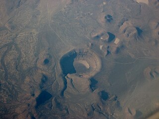
Lunar Crater volcanic field is a volcanic field in Nye County, Nevada. It lies along the Reveille and Pancake Ranges and consists of over two hundred vents, mostly small volcanic cones with associated lava flows but also several maars and Lunar Crater. Some vents have been eroded so heavily that the structures underneath the volcanoes have been exposed. Lunar Crater itself has been used as a testing ground for Mars rovers and as training ground for astronauts.

Markagunt Plateau is a volcanic field in southern Utah, United States. Formed in a region of older volcanics, it consists of several cinder cones and associated lava flows. Some of the lava flows feature lava tubes such as Mammoth Cave, while others have formed lava dams and lakes like Navajo Lake. Volcanism took place during the Pliocene and latest Pleistocene but may have continued into the Holocene; legends of the Southern Paiute may reflect past eruptions.


