Cromwell's Castle

Last updated

Cromwell's Castle
Tresco in the Isles of Scilly
CromwellsCastle.jpg
The castle, seen from the land
Isles of Scilly UK location map.svg
Red pog.svg
Cromwell's Castle
Coordinates 49°57′42″N6°21′02″W / 49.9616°N 6.3505°W / 49.9616; -6.3505 Coordinates: 49°57′42″N6°21′02″W / 49.9616°N 6.3505°W / 49.9616; -6.3505
Grid reference grid reference SV881159
TypeArtillery tower
Height15.1 metres (50 ft)
Site information
Controlled by English Heritage
Site history
MaterialsStone rubble
Official nameCromwell's Castle mid-17th century blockhouse and 18th century gun platform on the western coast of Castle Down, Tresco
Designated9 October 1981
Reference no. 1013275
Listed Building – Grade II*
Official nameCromwells Castle
Designated14 December 1992
Reference no. 1141198

Cromwell's Castle is an artillery fort overlooking New Grimsby harbour on the island of Tresco in the Isles of Scilly. It comprises a tall, circular gun tower and an adjacent gun platform, and was designed to prevent enemy naval vessels from entering the harbour. The castle was built in two phases; Sir Robert Blake constructed the tower between 1651 and 1652 in the aftermath of the Parliamentary invasion of the islands at the end of the English Civil War, and Master Gunner Abraham Tovey added the gun platform during the War of Jenkins' Ear around 1739. The tower fell into disuse soon afterwards, and in the 21st century is managed by English Heritage and open to visitors.

Contents

History

17th century

Cromwell's Castle is an artillery tower, built by Sir Robert Blake following the Parliamentary invasion of the Isles of Scilly in 1651. [1] During the English Civil War between 1642 and 1646, the inhabitants of the Isles had been Royalist supporters of King Charles I, and rebelled against Parliament in favour of Charles in 1648. [1] Tresco became a base for Royalist privateers and Parliament became concerned that the Dutch, then hostile to England, might exploit the situation, or that Royalist Irish forces might use the islands for an attack on England. [2] In 1651 Parliament sent Robert Blake and a naval force to retake the island, which had been fortified by the Royalists. [3]

The castle seen from the sea, overlooked by the ruined King Charles's Castle Cromwell Castle and King Charles's Castle.jpg
The castle seen from the sea, overlooked by the ruined King Charles's Castle

Having established control of the islands, between 1651 and 1652 Blake constructed Cromwell's Castle on Tresco, named after Oliver Cromwell, the Parliamentary leader. [4] It was intended to protect the deep water entrance to New Grimsby harbour on the west side of the island, a route which could also allow enemy vessels access through to the other Scilly Isles. [5] The Parliamentarian forces were particularly concerned about any potential Dutch attack. [6]

There were two existing fortifications in this location. [7] The main existing fort, King Charles's Castle, had been built in the 1550s but was poorly sited and had been blown up by its defenders when Blake's forces took the island. [8] There was also a small blockhouse beneath it, dating from the 16th century, and the new castle was built on top of this preexisting site. [9]

The castle initially comprised a three-storey circular tower, 13.45 metres (44.1 ft) across and 15.1 metres (50 ft) high, with walls almost 13 feet (4.0 m) thick, made from massive pieces of rubble; a later survey described the tower as "a Huge Mass of Masonry". [10] Some of the stone used came from the ruins of King Charles's Castle. [11] Six gun-ports with broad external splays on the roof allowed the battery a good angle of fire across the channel between the islands of Bryher and Tresco. [12] There may have been an adjacent gun platform just beneath the main structure. [9] The design was old-fashioned, resembling the circular keeps built by Henry VIII in the mid-16th century. [13]

17th–20th centuries

New Grimsby harbour in 1756, showing the castle (centre), overlooked by King Charles's Castle (right) New Grimsby Harbour, 1756.png
New Grimsby harbour in 1756, showing the castle (centre), overlooked by King Charles's Castle (right)

After the restoration of Charles II to the throne in 1660, a survey of the castle was carried out, which recommended repairs to the site. [14] A survey carried out at the end of the 1730s suggested that the castle had ten artillery positions, but that there were not enough guns on the island to arm both the castle and the other defences, and that some of the guns that were available were unusable. [15]

In 1739, the War of Jenkins' Ear broke out between Britain and Spain, and the decision was taken to improve the defences at Cromwell Castle. [16] Abraham Tovey, the Master Gunner at the nearby fortification known as the Garrison, constructed a large gun-platform for a battery of six guns on the south-west side of the tower, possibly on top of any pre-existing 16th-century platform. [17] A parapet protected the guns, a new entrance was cut into the main tower and other adjustments made. [18]

The antiquary William Borlase visited the castle in 1752, noting that the gun platform was armed with 9-pounder (4 kg) cannons and the tower roof with 4-pounder (1.8 kg) guns. [19] The site was now unmanned, however, and had fallen into decay since the construction work by Tovey. [19] The writer John Troutbeck, commenting at the end of the century, remarked on the tower having a "special bomb proof" roof, topped with 6-foot (1.8 m) high parapets. [20] He noted, that although there while still some old iron artillery guns present, the site was still ungarrisoned and in a state of disrepair. [20]

The Crown, in the form of the Duchy of Cornwall, had leased the Scilly Isles to the Godolphin family in 1687, followed by Augustus Smith in 1834. [21] In 1922, the lease passed to Smith's grand-nephew Arthur Dorrien-Smith, who agreed to pass several properties on Tresco, including the castle, into the guardianship of the Ministry of Works. [22]

21st century

Plan of the castle, ground floor (left), first floor (right): A - 18th century gun platform; B - guard house; C - latrines; D - 17th-century tower Cromwell's Castle plan with roof.png
Plan of the castle, ground floor (left), first floor (right): A – 18th century gun platform; B – guard house; C – latrines; D – 17th-century tower

In the 21st century, the castle is controlled by English Heritage, as the successor to the Ministry of Works, and open to visitors. The interior wooden floors have been lost, but the spiral staircase and the stone, vaulted roof remain intact and accessible. [23] English Heritage have commented that the castle is "one of only a few stone fortifications that survive from the Interregnum", and it is protected by UK law as a Grade II* listed building. [24]

See also

Related Research Articles

Tresco, Isles of Scilly Human settlement in England

Tresco is the second-biggest island of the Isles of Scilly in Cornwall, England. It is 297 hectares (1.15 sq mi) in size, measuring about 3.5 kilometres (2.2 mi) by 1.75 kilometres (1.09 mi).

St Marys, Isles of Scilly Human settlement in England

St Mary's is the largest and most populous island of the Isles of Scilly, an archipelago off the southwest coast of Cornwall in England.

Blockhouse type of fortification

A blockhouse is a small fortification, usually consisting of one or more rooms with loopholes, allowing its defenders to fire in various directions. It usually refers to an isolated fort in the form of a single building, serving as a defensive strong point against any enemy that does not possess siege equipment or, in modern times, artillery, air force and cruise missiles. A fortification intended to resist these weapons is more likely to qualify as a fortress or a redoubt, or in modern times, be an underground bunker. However, a blockhouse may also refer to a room within a larger fortification, usually a battery or redoubt.

Bryher Human settlement in England

Bryher is one of the smaller of the inhabited islands of the Isles of Scilly.

Kingswear Castle Grade I listed castle in South Hams, UK

Kingswear Castle is an artillery fort, built to protect Dartmouth harbour in Devon, England. It was constructed between 1491 and 1502 in response to the threat of French attack and was one of the first purpose-built artillery forts in Britain. By the end of the 16th century, however, improvements in the range of artillery weapons had reduced the utility of the castle. It took part in the English Civil War and continued to be armed until the early 18th century, but fell into ruin. Restored as a summer house in 1855, in the 21st century it is managed by the Landmark Trust as a holiday let.

Bayards Cove Fort English 16th-century artillery blockhouse.

Bayard's Cove Fort, also known historically as Berescove or Bearscore Castle, is an English 16th-century artillery blockhouse, built to defend the harbour entrance at Dartmouth in Devon. Constructed in the early part of the century, it had eleven gunports for heavy artillery and was intended to engage enemy vessels that broke past the external defences of the Dartmouth and Kingswear castles. It remained armed during the English Civil War, but was neglected in the 18th century and used for storage. The fort was restored in the late 19th century and is now managed by English Heritage and open to visitors.

King Charless Castle 16th century castle in the Isles of Scilly

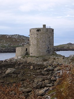
King Charles's Castle is a ruined artillery fort overlooking New Grimsby harbour on the island of Tresco in the Isles of Scilly. Built between 1548 and 1551 to protect the islands from French attack, it would have held a battery of guns and an accompanying garrison, designed to prevent enemy vessels from entering the harbour. The castle is polygonal in design, constructed from granite stone, with the gun battery at the front, and a dining room, kitchen and living accommodation at the rear. An additional defensive earthwork was constructed around it during the 17th century. The design of the castle is unusual for the period, and is only seen elsewhere in blockhouses along the River Thames.

Tresco Abbey Gardens

Tresco Abbey Gardens are located on the island of Tresco in the Isles of Scilly, United Kingdom. The 17 acre gardens were established by the nineteenth-century proprietor of the islands, Augustus Smith, originally as a private garden within the grounds of the home he designed and built. The gardens are designated at Grade I in the Register of Historic Parks and Gardens.

St Helens, Isles of Scilly

St Helen's is one of the fifty or so uninhabited islands in the archipelago of the Isles of Scilly and has an approximate area of 0.1885 square kilometres. On the south side of the island is one of the earliest Christian sites in Scilly, an early medieval religious complex, which is thought to be the remains of St Elidius Hermitage, an 8th-century chapel lived in by Saint Lide,. There are also the remains of an isolation hospital used to quarantine sailors with plague. The island is the major part of a Site of Special Scientific Interest and some features have been given the designation of scheduled ancient monument. Access to the island is through chartered or private boat, although there are some season trips throughout the summer. St Helen's is currently managed by the Isles of Scilly Wildlife Trust.

Isles of Scilly Group of islands off the south-westernmost point of mainland Britain

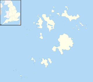
The Isles of Scilly is an archipelago off the southwestern tip of Cornwall. One of the islands, St Agnes, is the most southerly point in Britain, being over 4 miles (6.4 km) further south than the most southerly point of the British mainland at Lizard Point.

RNAS Tresco

RNAS Tresco was a Royal Naval Air Service base on Tresco, the second largest island in the Isles of Scilly. From February 1917 to May 1919 aircraft patrolled the Western Approaches and provided an escort for convoys. A total of thirteen U-boats were sighted and nine attacked.

Old Grimsby Human settlement in England

Old Grimsby is a coastal settlement on the island of Tresco in the Isles of Scilly, England. It is located on the east side of the island and there is a quay. At the southern end of the harbour bay is the Blockhouse, a 16th-century fort built to defend the harbour from attack.

Peninnis Head

Peninnis Head is the southernmost point of St Mary's, Isles of Scilly. The headland is within the Isles of Scilly Area of Outstanding Natural Beauty and part of the Heritage Coast. It is also a Geological Conservation Review site for its Quaternary geomorphology and was first designated a Site of Special Scientific Interest (SSSI) in 1971 for both its biological and geological interests. On the tip of the headland is a squat lighthouse built in 1911 by Trinity House as a replacement for the 17th century lighthouse on St Agnes.

Castle Down

Castle Down is a windswept plateau of maritime heath in the northern part of the island of Tresco, Isles of Scilly. The area has a number of designations including Castle Down (Tresco) Site of Special Scientific Interest (SSSI); is part of the Isles of Scilly Area of Outstanding Natural Beauty; part of the Isles of Scilly Heritage Coast; and part of Plantlife's Isles of Scilly Important Plant Area. There are a number of Schedule Ancient Monument's ranging in age from Bronze Age cairns to castles built in the 16th and 17th centuries to protect the anchorage of New Grimsby harbour.

Old Blockhouse Scheduled monument in Scilly, UK

The Old Blockhouse, also known as the Dover Fort, is a 16th-century fortification on the island of Tresco in the Isles of Scilly. It was built between 1548 and 1551 by the government of Edward VI to protect the islands against French attack.

Olivers Battery, Tresco Artillery battery on Tresco, UK

Oliver's Battery is a ruined artillery battery on the island of Tresco in the Isles of Scilly off of Cornwall, England. It was built by the Parliamentarian admiral, Sir Robert Blake, after he invaded Tresco in April 1651 during the years of the interregnum. It was used to bombard the neighbouring island of St Mary's, which was still held by an opposing Royalist army, and forced its surrender several weeks later. The battery comprised a triangle of ramparts, constructed using earth and rubble, which, combined with the natural stone features on the site, produced a substantial, if crude, fortification. It is now ruined, and owned by the Duchy of Cornwall.

Tresco is a civil parish in the Isles of Scilly, Cornwall, England. The parish contains 16 buildings that are recorded in the National Heritage List for England as designated listed buildings. Of these, two are listed at Grade II*, the middle grade, and the others are at Grade II, the lowest grade. The largest island in the parish is Tresco, and the parish also includes Round Island with its listed lighthouse. The oldest listed building consists of the ruins of a Benedictine priory dating from about 1300. The island had a strategic importance and this is reflected in its three listed fortifications. In the 19th century a country house, Tresco Abbey, was built close to the ruins of the priory, and its grounds have been transformed into Tresco Abbey Gardens. Listed buildings in addition to those mentioned above include houses, farm outbuildings, a church, a monument, and the wall of a former kelp pit.

Harrys Walls Fort in St Marys, Isles of Scilly, UK

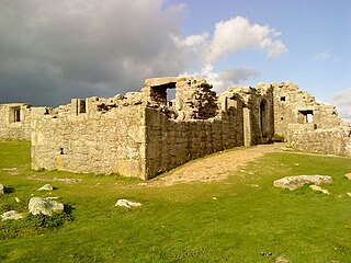
Harry's Walls are the remains of an unfinished artillery fort, started in 1551 by the government of Edward VI to defend the island of St Mary's in the Isles of Scilly. Constructed to defend the harbour of Hugh Town from possible French attack, the fortification incorporated Italianate-style bastions with protective orillons and would have been the most advanced design in the kingdom at the time. It was not completed, probably due to a shortage of funds and the passing of the invasion threat, and only the south-west side remains. In the 21st century, Harry's Walls are managed by English Heritage and open to visitors.

This is a list of scheduled monuments in Cornwall, United Kingdom. Monuments are listed by Historic England as part of the National Heritage List for England. For the scope of this list, the Isles of Sicily are included and the ceremonial county boundaries are used.

Dr Allan Brodie is a British historian and architectural historian. His expertise includes medieval ecclesiastical architecture and the history of tourism in Britain. He studied for his MA at the Courtauld Institute of Art, University of London in 1982, the subject of his dissertation being the chronology of the East End of Rochester Cathedral. Photographs contributed by Allan Brodie to the Courtauld's Conway Library archive are currently being digitised as part of the Courtauld Connects project. In 2021 he completed his Ph.D. at the University of Westminster on The Urban Character of the Early English Seaside Resort 1700-1847. The award was based on a new commentary, seven published papers and two books.

References

  1. 1 2 Bowden & Brodie 2011a , p. 9
  2. Bowden & Brodie 2011b , p. 20
  3. Bowden & Brodie 2011a , p. 9; Bowden & Brodie 2011b , p. 20
  4. O'Neil 1961 , p. 25
  5. "History of Cromwell's Castle", English Heritage, archived from the original on 27 August 2016, retrieved 23 August 2016
  6. Saunders 1989 , p. 82
  7. Bowden & Brodie 2011a , p. 9; Bowden & Brodie 2011b , p. 29
  8. Bowden & Brodie 2011a , p. 9; "History of Cromwell's Castle", English Heritage, archived from the original on 27 August 2016, retrieved 23 August 2016
  9. 1 2 Bowden & Brodie 2011b , p. 29
  10. O'Neil 1961 , p. 25; Brodie 2010 , p. 30; "Cromwell's Castle: Mid-17th Century Blockhouse and 18th Century Gun Platform on the Western Coast of Castle Down, Tresco", Historic England, archived from the original on 26 August 2016, retrieved 23 August 2016; "History of Cromwell's Castle", English Heritage, archived from the original on 27 August 2016, retrieved 23 August 2016
  11. "History of Cromwell's Castle", English Heritage, archived from the original on 27 August 2016, retrieved 23 August 2016; "King Charles Castle", Historic England, archived from the original on 15 September 2016, retrieved 1 September 2016
  12. O'Neil 1961 , p. 25; "Cromwell's Castle: Mid-17th Century Blockhouse and 18th Century Gun Platform on the Western Coast of Castle Down, Tresco", Historic England, archived from the original on 26 August 2016, retrieved 23 August 2016; "History of Cromwell's Castle", English Heritage, archived from the original on 27 August 2016, retrieved 23 August 2016
  13. Brodie 2010 , p. 30; Bowden & Brodie 2011b , pp. 27, 29
  14. Bowden & Brodie 2011b , pp. 29–30
  15. Brodie 2011 , p. 4
  16. Bowden & Brodie 2011a , p. 10
  17. O'Neil 1961 , p. 25 for Tovey
  18. O'Neil 1961 , pp. 25–26
  19. 1 2 Borlase 1756 , pp. 47–48; "Cromwell's Castle: Mid-17th Century Blockhouse and 18th Century Gun Platform on the Western Coast of Castle Down, Tresco", Historic England, archived from the original on 26 August 2016, retrieved 23 August 2016
  20. 1 2 Troutbeck 1796 , p. 126
  21. "Obituary - Major Dorrien-Smith", The Times, archived from the original on 28 March 2014, retrieved 29 January 2014
  22. O'Neil 1961 , p. 3; "Obituary - Major Dorrien-Smith", The Times, archived from the original on 28 March 2014, retrieved 22 August 2016
  23. "Cromwell's Castle: Mid-17th Century Blockhouse and 18th Century Gun Platform on the Western Coast of Castle Down, Tresco", Historic England, archived from the original on 26 August 2016, retrieved 23 August 2016
  24. "Cromwell's Castle: Mid-17th Century Blockhouse and 18th Century Gun Platform on the Western Coast of Castle Down, Tresco", Historic England, archived from the original on 26 August 2016, retrieved 23 August 2016; "History of Cromwell's Castle", English Heritage, archived from the original on 27 August 2016, retrieved 23 August 2016

Bibliography