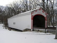
The Mercer's Mill Covered Bridge or Mercer's Ford Covered Bridge is a covered bridge that spans the East branch of the Octoraro Creek on the border between Lancaster County and Chester County in Pennsylvania, United States. A Lancaster County-owned and maintained bridge, its official designation is the East Octoraro #2 Bridge.

The Pine Grove Covered Bridge is a covered bridge that spans the East Branch of Octoraro Creek on the border between Lancaster County and Chester County in Pennsylvania, United States. It is the longest covered bridge in Lancaster County.
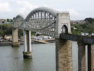
The Royal Albert Bridge is a railway bridge which spans the River Tamar in England between Plymouth, Devon and Saltash, Cornwall. Its unique design consists of two 455-foot (138.7 m) lenticular iron trusses 100 feet (30.5 m) above the water, with conventional plate-girder approach spans. This gives it a total length of 2,187.5 feet (666.8 m). It carries the Cornish Main Line railway in and out of Cornwall. It is adjacent to the Tamar Bridge which opened in 1962 to carry the A38 road.

The Richmond–San Rafael Bridge is the northernmost of the east–west crossings of the San Francisco Bay in California, USA. Officially named after California State Senator John F. McCarthy, it bridges Interstate 580 from Richmond on the east to San Rafael on the west. It opened in 1956, replacing ferry service by the Richmond–San Rafael Ferry Company.
Rock Creek is an 18.9-mile-long (30.4 km) tributary of the Monocacy River in south-central Pennsylvania and serves as the border between Cumberland and Mount Joy townships. Rock Creek was used by the Underground Railroad and flows near several Gettysburg Battlefield sites, including Culp's Hill, the Benner Hill artillery location, and Barlow Knoll.

The Bi-State Vietnam Gold Star Twin Bridges,, connect Henderson, Kentucky and Evansville, Indiana along U.S. Route 41 (US 41), two miles (3.2 km) south of the (temporary) southern terminus of Interstate 69 (I-69). T Because the bridges carry 40,000 vehicles a day across the Ohio River on average, often more, and because the nearest crossings over the Ohio River are more than 40 miles up or downstream, bottlenecks and congestion are frequent, even daily problems. A problem that is expected to be relived by the construction of the I-69 crossing over the Ohio River, planned to begin sometime in 2021.

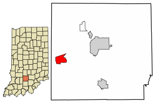
Liberty Mills is an unincorporated community on the Eel River in Chester Township, Wabash County, in the U.S. state of Indiana. Proprietor John Comstock (1802–1879) platted the town June 24, 1837. The name Liberty Mills comes from the number of mills the town once operated, including a saw mill, a carding mill, and a distillery, with one of the mills coming from the ‘Liberty’ brand. Its ZIP code is 46946.

The Mount Orne Bridge is a covered bridge over the Connecticut River between Lancaster, New Hampshire, and Lunenburg, Vermont. It joins Elm Street in South Lancaster with River Road in Lunenburg. Built in 1911, it is one of two Howe truss bridges across the Connecticut River. It was listed on the National Register of Historic Places in 1976.

The Old Union Crossing Covered Bridge is a privately owned wood & metal combination style covered bridge that spans the West Fork of the Little River in DeKalb County, Alabama, United States. It is located on an access road between Shady Grove Dude Ranch and Cloudmont Ski & Golf Resort on Lookout Mountain, which is off County Road 614 near the town of Mentone. Coordinates are 34°32′3.51″N85°35′56.47″W.

The Beeson Covered Bridge originally crossed Roaring Creek, one mile (1.6 km) northwest of Marshall, Indiana, on County Road 216, in Washington Township, Parke County. The bridge was moved to its current location in Billie Creek Village in December 1979.

The Catlin Covered Bridge is a single span Burr Arch truss covered bridge structure that was built by Clark McDaniel in 1907.

The Leatherwood Station Covered Bridge is a single span double Burr Arch Truss covered bridge structure that was built by Joseph A. Britton & Son in 1899. Originally it had sandstone abutments but when it was moved to Billie Creek Village they were replaced with concrete abutments with sandstone showing.

The Portland Mills Covered Bridge is the second oldest covered bridge in Parke County, Indiana, being built the same year as the Crooks Covered Bridge. It is a single span Burr Arch Truss covered bridge that was built by Henry Wolf in 1856.
Williams is an unincorporated census-designated place in Spice Valley Township, Lawrence County, Indiana. Williams is situated on the White River. Williams is home to Williams Dam, a hydroelectric dam that once powered the electricity for stone industries across Southern Indiana, especially in nearby Bedford and Bloomington.

Deer's Mill is an unincorporated community in Ripley Township, Montgomery County, in the U.S. state of Indiana.

The Tulip Viaduct is a 2,295-foot (700 m) long railroad bridge in Greene County, Indiana, that spans Richland Creek between Solsberry and Tulip. According to Richard Simmons and Francis Haywood Parker, authors of Railroads of Indiana, it is "easily the state's most spectacular railroad bridge". The bridge was built in 1905 and 1906 by the Indianapolis Southern Railway and successor Indianapolis Southern Railroad, which became part of the Illinois Central Railroad in 1911. It is now part of the Indianapolis–Newton, Illinois, line of the Indiana Rail Road.

Water Street Bridge is a truss bridge that spans the Susquehanna River between West Pittston, Pennsylvania and Pittston, Pennsylvania. It was built in 1914 by the Penn Bridge Company.

The Jessup Covered Bridge was north of Jessup, Indiana. The single-span Burr Arch covered bridge structure was built by the Jefferson P. Van Fossen in 1910 and destroyed by flood in 1989.

Duck Creek Aqueduct, also known as the Metamora Aqueduct and Whitewater Canal Aqueduct, is a historic aqueduct carrying the Whitewater Canal over Duck Creek in Metamora Township, Franklin County, Indiana. It is the only surviving covered wood aqueduct in the United States as such it is a form of covered bridge. It is a single-span Burr through truss aqueduct and measures approximately 90 feet (27 m) long, 25 feet (7.6 m) wide, and 25 feet (7.6 m) deep. The original aqueduct was built between 1839 and 1843. The present structure was built in 1846, after the original aqueduct was washed out in a flood. It was strengthened in 1868, and repaired in 1901. After abandonment and deterioration, the Duck Creek Aqueduct was restored to its present appearance in 1946-1949.

The Follett Stone Arch Bridge Historic District encompasses a group of four stone arch bridges in southwestern Townshend, Vermont. All four bridges were built by James Otis Follett, a local self-taught mason, between 1894 and 1910, and represent the single greatest concentration of surviving bridges he built. The district was listed on the National Register of Historic Places in 1976.