
Mackinac Island is an island and resort area, covering 4.35 square miles (11.3 km2) in land area, in the U.S. state of Michigan. The name of the island in Odawa is Michilimackinac and "Mitchimakinak" in Ojibwemowin, meaning "Great Turtle". It is located in Lake Huron, at the eastern end of the Straits of Mackinac, between the state's Upper and Lower Peninsulas. The island was long home to an Odawa settlement and previous indigenous cultures before European colonization began in the 17th century. It was a strategic center of the fur trade around the Great Lakes. Based on a former trading post, Fort Mackinac was constructed on the island by the British during the American Revolutionary War. It was the site of two battles during the War of 1812 before the northern border was settled and the US gained this island in its territory.

Mackinac County is a county in the Upper Peninsula of the U.S. state of Michigan. As of the 2020 census, the population was 10,834. The county seat is St. Ignace. Formerly known as Michilimackinac County, in 1818 it was one of the first counties of the Michigan Territory, as it had long been a center of French and British colonial fur trading, a Catholic church and Protestant mission, and associated settlement.
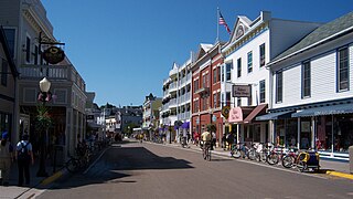
Mackinac Island is a city in Mackinac County in the U.S. state of Michigan. As of the 2020 census, the city had a population of 583.

Fort Mackinac is a former British and American military outpost garrisoned from the late 18th century to the late 19th century in the city of Mackinac Island, Michigan, on Mackinac Island. The British built the fort during the American Revolutionary War to control the strategic Straits of Mackinac between Lake Michigan and Lake Huron, and by extension the fur trade on the Great Lakes. The British did not relinquish the fort until thirteen years after the end of the American Revolutionary War. Fort Mackinac later became the scene of two strategic battles for control of the Great Lakes during the War of 1812. During most of the 19th century, it served as an outpost of the United States Army. Closed in 1895, the fort has been adapted as a museum on the grounds of Mackinac Island State Park.

Fort Michilimackinac was an 18th-century French, and later British, fort and trading post at the Straits of Mackinac; it was built on the northern tip of the lower peninsula of the present-day state of Michigan in the United States. Built around 1715, and abandoned in 1783, it was located along the Straits, which connect Lake Huron and Lake Michigan of the Great Lakes of North America.
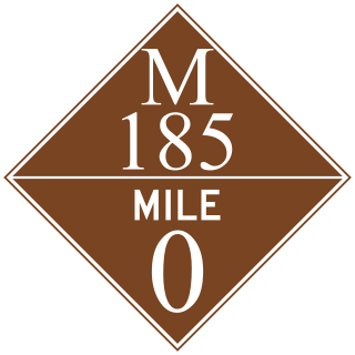
M-185 is a state trunkline highway in the U.S. state of Michigan that circles Mackinac Island, a popular tourist destination on the Lake Huron side of the Straits of Mackinac, along the island's shoreline. A narrow paved road of 8.004 miles (12.881 km), it offers scenic views of the straits that divide the Upper and the Lower peninsulas of Michigan and Lakes Huron and Michigan. It has no connection to any other Michigan state trunkline highways—as it is on an island—and is accessible only by passenger ferry. The City of Mackinac Island, which shares jurisdiction over the island with the Mackinac Island State Park Commission (MISPC), calls the highway Main Street within the built-up area on the island's southeast quadrant, and Lake Shore Road elsewhere. M-185 passes by several important sites within Mackinac Island State Park, including Fort Mackinac, Arch Rock, British Landing, and Devil's Kitchen. Lake Shore Road carries the highway next to the Lake Huron shoreline, running between the water's edge and woodlands outside the downtown area.
Mackinac Island State Park is a state park located on Mackinac Island in the U.S. state of Michigan. A Lake Huron island, it is near the Straits of Mackinac. The island park encompasses 1,800 acres (7.3 km2), which is approximately 80% of the island's total area. The park is also within the boundaries of the city of Mackinac Island and has permanent residents within its boundaries. M-185 circles the perimeter of the park as the only motorless highway in the state due to the island's ban of automobiles. The park is governed by the Michigan Department of Natural Resources and the Mackinac Island State Park Commission. On July 15, 2009, the park celebrated its 20 millionth visitor.
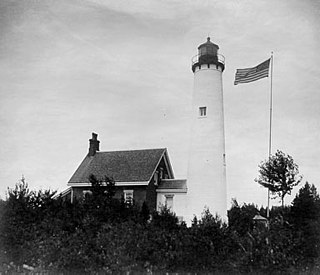
The buildings of the St Helena Light complex are the sole surviving structures on St. Helena Island, in Mackinac County in the U.S. state of Michigan. The lighthouse on the St. Helena Island's southeastern point was built in 1872-1873 and went into operation in September 1873. It became one of a series of lighthouses that guided vessels through the Straits of Mackinac, past a dangerous shoal that extends from the island.

Sugar Loaf is a 75-foot-high (23m) landlocked rock or stack in the interior of Mackinac Island in Lake Huron. Created by erosion during the period of postglacial Lake Algonquin, Sugar Loaf is the largest post-glacial erosion feature in the Straits of Mackinac.

The Richard and Jane Manoogian Mackinac Art Museum is an art museum located in the historic Indian Dormitory building on Mackinac Island, Michigan. The museum's exhibits feature art inspired by Mackinac Island, including historic painting and maps, photographs from the mid-19th to the mid-20th century, Native American art and beaded garments, and contemporary art and photography from area artists.

The Mission House, on Mackinac Island, is a historic structure owned by the state of Michigan. Built in 1825, it is listed on the National Register of Historic Places and is operated as part of the Mackinac Island State Park. The Mission House is a wood-frame structure covered in clapboard siding and constructed in a U shape. The center section is three stories, and the flanking wings are two stories. The front facade has a single-story porch covering the entrance in the center.

Arch Rock is a geologic formation on Mackinac Island in Michigan. It is a natural limestone arch formed during the Nipissing post-glacial period, a period of high Lake Huron levels following the end of the Wisconsin glaciation. To this day Arch Rock stands on the Lake Huron shoreline 146 feet (45 m) above the water.
Devil's Kitchen may refer to:
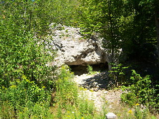
Skull Cave is a small and shallow cave on the central heights of Mackinac Island in Michigan, United States. The cave was carved during the Algonquin post-glacial period by the waters of Lake Algonquin, a swollen meltwater ancestor of today's Lake Huron.

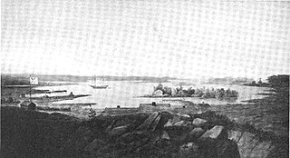
British Landing is a place within Mackinac Island, Michigan and is located on the shore of Mackinac Island, two miles (3 km) northwest of the island's downtown and harbor. British Landing is the site of a War of 1812 amphibious operation on July 16–17, 1812, by a joint force of the British Army and their allies among the Native Americans and indigenous people of Canada. The operation led directly to the surrender of Fort Mackinac by the U.S. Army.

The Biddle House is a historic house and fur trade shop space, built before 1800 on Market Street on Mackinac Island in the U.S. state of Michigan. It is part of Mackinac Island State Park. It is a Michigan Registered Site and a contributing resource to Mackinac Island's status as a National Historic Landmark.
Devil's Cave may refer to:
Fort Drummond, also known as Fort Colyer or Fort Collier, is a military fort located on the west end of Drummond Island on Whitney Bay, in the vicinity of De Tour Village, Michigan. It is the only known military and civilian site established by British forces on American soil following the War of 1812. It was listed on the National Register of Historic Places in 1969 and designated a Michigan State Historic Site in 1956.
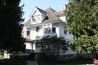
The Michigan Governor's Summer Residence, also known as the Lawrence A. Young Cottage, is a house located at the junction of Fort Hill and Huron roads on Mackinac Island, Michigan. It was listed on the National Register of Historic Places in 1997.


