It included Penmon, the easternmost point of the island, opposite which is Puffin Island (Ynys Seiriol). It bordered the commote of Menai (the other commote of Rhosyr) to the west, and the commote of Twrcelyn in the cantref of Cemais, to the north.
The commote court and maerdref was at Llanfaes, the commote's most important settlement. Later in the Middle Ages, Llywelyn the Great founded a monastery at Llanfaes; his wife Siwan was buried there. Previously the commote had one of Anglesey's two most important religious communities in Penmon, which became a priory (Penmon Priory) in the 12th century.
Later, Dindaethwy was the home of Penmynydd, the family estate of the Tudors of Anglesey.
The name means "Fort of the Daethwy", which may refer to the hillfort of Bwrdd Arthur ("Arthur's Table") in the former parish of Llanfihangel Din Sylwy. The Daethwy were the local Celtic tribe, who also gave their name to the village of Porthaethwy (Menai Bridge). Alternative names are Tindaethwy and Tyndaethwy (Dindaethwy may be a lenited version of Tindaethwy). The fort of Dinas, in the parish of Llandysilio, may have been the tribal centre.
The word Dindaethwy also appears in the name of Cynan Dindaethwy, king of Gwynedd at the start of the 9th century, as he was from this part of Anglesey.
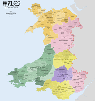
A commote was a secular division of land in Medieval Wales. The word derives from the prefix cym- and the noun bod. The English word "commote" is derived from the Middle Welsh cymwt.
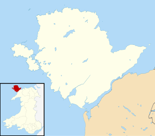
Llangoed is a small village, community and electoral ward just north of Beaumaris, on the Isle of Anglesey, at grid reference SH609793. The Royal Mail postcode begins LL58. Llangoed ward has a population of 1,275 (2001), falling at the 2011 census to 1,229.
Cynan Dindaethwy or Cynan ap Rhodri was a king of Gwynedd in Wales in the Early Middle Ages. Cynan was the son of Rhodri Molwynog and ascended to the throne of Gwynedd upon the death of King Caradog ap Meirion in 798. His epithet refers to the commote of Dindaethwy in the cantref Rhosyr. Unlike later kings of Gwynedd, usually resident at Aberffraw in western Anglesey, Cynan maintained his court at Llanfaes on the southeastern coast. Cynan's reign was marked by a destructive dynastic power struggle with a rival named Hywel, usually supposed to be his brother.
The Rothsay Castle was a paddle steamer built in 1816 for service on the River Clyde, Scotland, and was later transferred to Liverpool, England, where she was used for day trips along the coast of North Wales. She was shipwrecked on the Lavan Sands at the eastern end of the Menai Strait, North Wales, in 1831, with the loss of 130 lives.
Puffin Island is an uninhabited island off the eastern tip of Anglesey, Wales. It was formerly known as Priestholm in English and Ynys Lannog in Welsh. A hermitage was established here around the 6th century, and there are remains of a 12th-century monastery on the island. The island is also a Special Protection Area for wildlife.
The Anglesey Coastal Path is a 200-kilometre (124 mi) long-distance footpath around the island of Anglesey in North Wales. The route is part of the Wales Coast Path.
Penmon is a promontory, village and ecclesiastical parish on the eastern tip of the Isle of Anglesey in Wales, about 3 miles (4.8 km) east of the town of Beaumaris. It is in the community of Llangoed. The name comes from Welsh: pen and Môn, which is the Welsh word for Anglesey. It is the site of a historic monastery and associated 12th-century church. Walls near the well next to the church may be part of the oldest remaining Christian building in Wales. Penmon also has an award-winning beach and the Anglesey Coastal Path follows its shores. Quarries in Penmon have provided stone for many important buildings and structures, including Birmingham Town Hall and the two bridges that cross the Menai Strait. The area is popular with locals and visitors alike for its monuments, tranquillity, bracing air and fine views of Snowdonia to the south across the Menai Strait.
Arfon was a mediaeval Welsh cantref in north-west Wales. It was the core of the kingdom of Gwynedd. Later it was included in the new county of Caernarfonshire, together with Llŷn and Arllechwedd under the terms of the Statute of Rhuddlan in 1284. The island of Anglesey faced it across the Menai Strait; to the east was the cantref of Arllechwedd, to the south the cantref of Eifionydd, and to the west was the cantref of Llŷn.
Llanidan is a community in the south of Anglesey, Wales which includes the village of Brynsiencyn. The parish is along the Menai Strait, about 4 miles north-east of Caernarfon. The parish church of St Nidan is near the A4080 highway, a little to the east of Brynsiencyn. The ruins of an earlier parish church survive.
Llanfaes is a small village on the island of Anglesey, Wales, located on the shore of the eastern entrance to the Menai Strait, the tidal waterway separating Anglesey from the north Wales coast. Its natural harbour made it an important medieval port and it was briefly the capital of the kingdom of Gwynedd. Following Prince Madoc's Rebellion, Edward I removed the Welsh population from the town and rebuilt the port a mile to the south at Beaumaris. It is in the community of Beaumaris.
Aberffraw was one of the three medieval cantrefs on the island of Anglesey, north Wales, in the Kingdom of Gwynedd. It lay on the western side of the island on Caernarfon Bay. Its administrative centre was Aberffraw, ancient seat of the Princes of Gwynedd.
The Isle of Anglesey is a county off the north-west coast of Wales. It is named after the island of Anglesey, which makes up 94% of its area, but also includes Holy Island and some islets and skerries. The county borders Gwynedd across the Menai Strait to the southeast, and is otherwise surrounded by the Irish Sea. Holyhead is the largest town, and the administrative centre is Llangefni. The county is part of the preserved county of Gwynedd.
Llanfihangel Din Sylwy is a small, coastal (former) parish in the commote of Dindaethwy in north-east Anglesey, three miles north-northwest of Beaumaris.
The Roman conquest of Anglesey refers to two separate invasions of Anglesey in North West Wales that occurred during the early decades of the Roman conquest of Britain in the 1st century AD. The first invasion of North Wales began after the Romans had subjugated much of southern Britain. It was led by the Provincial governor of Britannia, Suetonius Paulinus, who led a successful assault on the island in AD 60–61, but had to withdraw because of the Boudican revolt. In AD 77, Gnaeus Julius Agricola's thorough subjugation of the island left it under Roman rule until the end of Roman rule in Britain in the early 5th century AD.
Llangaffo is a village in Anglesey, in north-west Wales. It lies along the B4419 and B4421 roads, north of Dwyran, south of Gaerwen and northwest of Llanidan. It is named after Caffo, a 6th-century saint. A church, St Caffo's Church, is named after him. A war memorial, a village hall and a primary school are also located in the village. The 1851 census recorded 138 people in the village, 75 males, 63 females and a parish area of 1,590 acres (640 ha). It is in the community of Rhosyr. The 2011 census recorded a population of 357.
St Mary's Church, Llanfair-yn-y-Cwmwd is a small medieval parish church near the village of Dwyran, in Anglesey, north Wales. The building probably dates from the 15th century, with some alterations. It contains a 12th-century carved stone font and a 13th-century decorated coffin lid. The bell is inscribed with the year of its casting, 1582. The historian Henry Rowlands was vicar of St Mary's in the late 17th and early 18th centuries. Maurice Wilks, who invented the Land Rover, is buried in the churchyard.
Llanfaes Friary was a Franciscan friary in the now vanished medieval town of Llanfaes, close to what is now Beaumaris, in south east Anglesey, Wales. It was founded around 1237 in memory of Joan, wife of Llywelyn ab Iorwerth. The Friary survived the depopulation of the town, but was dissolved in 1538 and most of the buildings dismantled soon afterwards. The land became an estate on which, in 1623, Rowland Whyte built a house which he called Friars. It became one of the many properties of the Bulkeley family, and was substantially rebuilt in 1866. By the 20th century the house and grounds were owned by James Hartley Burton. In 1939 they were requisitioned for wartime use, adapting and repairing flying boats, by Saunders-Roe, who continued after the war with a wide variety of light engineering activities. The industrial uses finally came to an end in the late 1990s. An archaeological dig on the site in 1991 identified substantial buried remains of the friary church and other monastic buildings. The site is a Scheduled monument.
The Menai Strait fish weirs are historically important fishing traps used in the fast-flowing tidal waters of the Menai Strait, which separates Anglesey from the rest of North Wales. The strait was particularly well suited to utilising fish weirs. The tidal waters pull huge volumes of water past the coastline with every tide, and the weirs and traps enabled fish to be concentrated into small holding areas from which they can be readily caught. Such methods are thought to have been used from earliest times, but the submerged and standing remains along both the Anglesey and Gwynedd coasts are from medieval and post-medieval periods, and in some cases were still in use into the 20th century.
Rhosyr was the name of one of the three medieval cantrefs on the island of Anglesey, north Wales, in the Kingdom of Gwynedd. It lay on the southern side of the island facing the Menai Strait which separates Anglesey from the mainland.
Lavan Sands is an intertidal sandbank found in the Menai Strait between Bangor, Gwynedd and Llanfairfechan, Wales. Totally underwater at high tide, at extreme low tides it measures 5.5-mile (8.9 km) east-west and 3.25-mile (5.23 km) north-south. At the western end is found another sandbank Bangor Flats and just north is the sandbank Dutchman's Bank. At low tide the Lavan Sands make the narrowest part of the Menai Straits, at Beaumaris, a mere 237 m (778 ft). The area is designated as an SSSI due in part to the large numbers of Eurasian oystercatchers that migrate there due to the freshwater streams that flow across it.
This page is based on this Wikipedia article Text is available under the CC BY-SA 4.0 license; additional terms may apply. Images, videos and audio are available under their respective licenses.