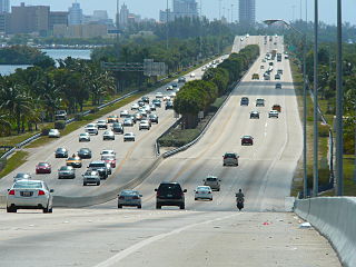
Interstate 195 (I-195) is a 4.4-mile-long (7.1 km) spur freeway connecting I-95 in the west with Miami Beach in the east. It crosses Biscayne Bay by traveling over the Julia Tuttle Causeway, named after Miami founder Julia Tuttle.

U.S. Route 319 is a spur of U.S. Route 19. It runs for 303 miles (488 km) from the foot of the John Gorrie Memorial Bridge across from downtown Apalachicola, Florida to US 1/SR 4 in Wadley, Georgia, through the Panhandle of Florida and the southern portion of Georgia.
State Road 513, also known as South Patrick Drive, is a short north–south road located along the western side of the barrier island towns of Indian Harbour Beach, Satellite Beach and South Patrick Shores in Brevard County. The southern terminus is at an intersection with SR 518 near the eastern end of the Eau Gallie Causeway in Indian Harbour Beach. The northern terminus is at a partial interchange with the Pineda Causeway, just south of the southern entrance of Patrick Air Force Base.
State Road 518, also called Eau Gallie Boulevard, is a short but major east–west highway with a western terminus at Interstate 95 on the Florida mainland, crossing the Indian River via the Eau Gallie Causeway, and having its eastern terminus at SR A1A. Most of SR 518 is located within the city of Melbourne.

State Route 7 (SR 7) is a state highway in Lewis and Pierce counties, located in the U.S. state of Washington. The 58.60-mile (94.31 km) long roadway begins at U.S. Route 12 (US 12) in Morton and continues north to intersect several other state highways to Tacoma, where it ends at an interchange with Interstate 5 (I-5) and I-705. The road has several names, such as Second Street in Morton, the Mountain Highway in rural areas, Pacific Avenue in Spanaway, Parkland and Tacoma and 38th Street in Tacoma. Near the end of the highway there is a short freeway that has been proposed to be extended south parallel to an already existing railroad, owned by Tacoma Rail, which serves as the median of the short freeway.
State Road 907, also known as Alton Road and 63rd Street, is a major north–south artery in Miami Beach, Florida, USA, extending 5.659-mile (9.107 km). It is one of a few of the state roads that have both termini on the same state route. In this case, the southern terminus is the intersection of Alton Road and Fifth Street, and the northern terminus is the intersection of 63rd Street and Collins Avenue. Alton Road snakes up the western side of the barrier islands comprising Miami Beach, while Collins Avenue parallels the Atlantic shore to the east. In addition, SR 907 is often used as a bypass for the oft-congested SR A1A.
State Road 404 (SR 404), the Pineda Causeway, is an east–west divided highway currently running from Interstate 95 (I-95) to SR A1A at Patrick Air Force Base, Florida, US. It was opened as a toll road in 1971 and classified as a state road two years later. The tolls were removed in 1990. It was named after Pineda, a former village east of Suntree on U.S. Route 1 (US 1). With interchanges at US 1 (SR 5), South Tropical Trail, and South Patrick Drive (SR 513), the Pineda Causeway is the primary access for Patrick Air Force Base and the southern end of Merritt Island. From US 1 to the eastern terminus, it is part of the Indian River Lagoon Scenic Highway system.
State Road 916, locally known as Northwest 138th Street, West 84th Street, North 135th Street, Opa-locka Boulevard, and Natural Bridge Road is a 10.253 miles (16.501 km) long east–west highway crossing northern Miami-Dade County, Florida. Its western terminus is at an interchange with Interstate 75, the Palmetto Expressway, and the Gratigny Parkway on the boundary between Hialeah and Miami Lakes, traveling east to Biscayne Boulevard.
State Road 944, locally known as Hialeah Drive and North 54th Street, is a 5.822-mile-long east–west street spanning Hialeah and Miami, Florida. The western terminus is an intersection with Okeechobee Road in Hialeah; its eastern terminus is an intersection with Biscayne Boulevard. Along with the north–south Palm Avenue, Hialeah Drive is a baseline for addresses in the City of Hialeah.
A major east–west commercial artery in northern Miami-Dade County, State Road 932 is a 9.7-mile (15.6 km)-long four-lane highway connecting US 27 in Hialeah Gardens and SR 915 in Miami Shores, just south of the campus of Barry University. Locally, SR 932 is also known as North 103rd Street in greater Miami, and as 49th Street or Palm Springs Mile in Hialeah.

State Route 120 (SR 120) is a 90.7-mile-long (146.0 km) state highway that runs west-to-east through portions of Haralson, Paulding, Cobb, Fulton, and Gwinnett counties in northwestern part of the U.S. state of Georgia.

State Route 41 is a primary state highway in the U.S. state of Virginia. Known as Franklin Turnpike, the state highway runs 22.5 miles (36.2 km) from SR 360 northeast of Danville to SR 57 in Callands. The Virginia Department of Transportation (VDOT) officially designates the route north of U.S. Route 29 Bus. in Danville as a part of SR 41 but the Franklin Turnpike south and east of this point is signed as SR 41.

State Route 508 (SR 508) is a 32.84-mile (52.85 km) long state highway located in Lewis County within the U.S. state of Washington, extending from an interchange with Interstate 5 (I-5) concurrent with U.S. Route 12 (US 12) in Napavine to SR 7 in Morton. By 1916, a road between Napavine and Cinebar was constructed on the current route of SR 508 and was signed in 1937 as Secondary State Highway 5K (SSH 5K) after being extended to Morton. SSH 5K became SR 508 in 1968 and since then, a segment in Bear Canyon has been reconstructed twice between 2007 and 2009 and a bridge over the Tilton River was reconstructed in 2009.
Several special routes of U.S. Route 1 exist, from Florida to Maine. In order from south to north, separated by type, these special routes are as follows.
A total of at least twenty-three special routes of U.S. Route 17 have existed.


