
Barrier islands are coastal landforms and a type of dune system that are exceptionally flat or lumpy areas of sand that form by wave and tidal action parallel to the mainland coast. They usually occur in chains, consisting of anything from a few islands to more than a dozen. They are subject to change during storms and other action, but absorb energy and protect the coastlines and create areas of protected waters where wetlands may flourish. A barrier chain may extend uninterrupted for over a hundred kilometers, excepting the tidal inlets that separate the islands, the longest and widest being Padre Island of Texas. Sometimes an important inlet may close permanently, transforming an island into a peninsula, thus creating a barrier peninsula. The length and width of barriers and overall morphology of barrier coasts are related to parameters including tidal range, wave energy, sediment supply, sea-level trends, and basement controls. The amount of vegetation on the barrier has a large impact on the height and evolution of the island.

Álvar Núñez Cabeza de Vaca was a Spanish explorer of the New World, and one of four survivors of the 1527 Narváez expedition. During eight years of traveling across what is now the US Southwest, he became a trader and faith healer to various Native American tribes before reconnecting with Spanish civilization in Mexico in 1536. After returning to Spain in 1537, he wrote an account, first published in 1542 as La relación y comentarios, which in later editions was retitled Naufragios y comentarios. Cabeza de Vaca is sometimes considered a proto-anthropologist for his detailed accounts of the many tribes of Native Americans that he encountered.

Galveston Island is a barrier island on the Texas Gulf Coast in the United States, about 50 miles (80.5 km) southeast of Houston. The entire island, with the exception of Jamaica Beach, is within the city limits of the City of Galveston in Galveston County.

Pánfilo de Narváez was a Spanish conquistador and soldier in the Americas. Born in Spain, he first embarked to Jamaica in 1510 as a soldier. He came to participate in the conquest of Cuba and led an expedition to Camagüey escorting Bartolomé de las Casas.
The Karankawa were an Indigenous people concentrated in southern Texas along the coast of the Gulf of Mexico, largely in the lower Colorado River and Brazos River valleys. They consisted of several independent seasonal nomadic groups who shared the same language and much of the same culture. From the onset of European colonization, the Karankawa had violent encounters with the Spanish. After one attack by the Spanish, who ambushed the Karankawa after the establishment of Presidio La Bahía in 1722, the Karankawa allegedly felt "deeply betrayed [and] viewed Spanish colonial settlement with hostility."

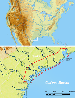
The Narváez expedition was a Spanish journey of exploration and colonization started in 1527 that intended to establish colonial settlements and garrisons in Florida. The expedition was initially led by Pánfilo de Narváez, who died in 1528. Many more people died as the expedition traveled west along the explored Gulf Coast of the present-day United States and into the American Southwest. Only four of the expedition's original members survived, reaching Mexico City in 1536. These survivors were the first known non-Native Americans to see the Mississippi River, and to cross the Gulf of Mexico and Texas.

Pinus remota, commonly known as the Texas pinyon or papershell pinyon, is a pine in the pinyon pine group, native to southwestern Texas and northeastern Mexico. It can be distinguished from other pinyon species by its thin-walled seeds, which made it especially attractive as a food to Indians and Mexicans living where it grew. Spanish explorer Cabeza de Vaca noted that the papershell pinon was an important food for the Indians in 1536.
Estevanico, also known as Esteban de Dorantes or Mustafa Azemmouri, was a man from present-day Morocco who became the first North African of Berber origin to explore North America.

Tomás Jesús Yarrington Ruvalcaba is a Mexican politician affiliated with the Institutional Revolutionary Party PRI. He held office as the Mayor of Matamoros from 1993 to 1995, and the Governor of Tamaulipas from 1999 to 2005. Yarrington sought nomination for the presidential elections for the PRI in 2005.

Key Vaca is an island in the middle Florida Keys, located entirely within the borders of the city of Marathon, Florida.

Galveston Island State Park is a Texas state park located on western Galveston Island in Galveston County, on the western Gulf Coast in Texas.
San Luis Pass is a strait of water at the south-western end of Galveston Island off the shores of the U.S. state of Texas. It connects the sheltered waters of West Bay to the open Gulf of Mexico. Swimmers and fishermen have been killed in the Pass' treacherous waters, largely due to murky water, uncharted drop-offs, and fast moving currents. The San Luis Pass-Vacek Toll Bridge spans San Luis Pass into Brazoria County.

Arcadia was an unincorporated area in Galveston County, Texas, United States, which is now a neighborhood of the city of Santa Fe. It sits at an elevation of 30 feet (9 m).

The Texas barrier islands are a chain of barrier islands in the Gulf of Mexico along the coast of Texas. The islands enclose a series of estuaries along the Texas coast and attract tourists for activities such as recreational fishing and dolphin watching. The seven barrier islands, listed from northeast to southwest, are Galveston Island, Follet's Island, Matagorda Island, San José Island, Mustang Island, Padre Island, and Brazos Island.
Alonso del Castillo Maldonado was an early Spanish explorer in the Americas. He was one of the last four survivors of the Pánfilo de Narváez expedition, along with Álvar Núñez Cabeza de Vaca, Andrés Dorantes de Carranza and his African slave Estevanico. They were the early non-native people to travel and be enslaved in the Southwest region of the modern United States. Castillo Maldonado lived with a Native American tribe in Texas in 1527 and 1528.
Andrés Dorantes de Carranza, was an early Spanish explorer in the Americas. He was one of the four last survivors of the Narváez expedition, along with Álvar Núñez Cabeza de Vaca, Dorantes' slave Estevanico, and Alonso del Castillo Maldonado.

Francisco Javier García Cabeza de Vaca is a Mexican politician affiliated with the PAN, and the current Governor of Tamaulipas. García has previously served as a local and federal legislator, having served one term in the Chamber of Deputies and three and a half years in the Senate.

The Old Spanish Trail half dollar is a commemorative coin struck by the United States Bureau of the Mint in 1935. The coin was designed by L. W. Hoffecker, a coin dealer, who also was in charge of its distribution.

The U.S. state of Texas has a series of estuaries along its coast on the Gulf of Mexico, most of them bounded by the Texas barrier islands. Estuaries are coastal bodies of water in which freshwater from rivers mixes with saltwater from the sea. Twenty-one drainage basins terminate along the Texas coastline, forming a chain of seven major and five minor estuaries: listed from southwest to northeast, these are the Rio Grande Estuary, Laguna Madre, the Nueces Estuary, the Mission–Aransas Estuary, the Guadalupe Estuary, the Colorado–Lavaca Estuary, East Matagorda Bay, the San Bernard River and Cedar Lakes Estuary, the Brazos River Estuary, Christmas Bay, the Trinity–San Jacinto Estuary, and the Sabine–Neches Estuary. Each estuary is named for its one or two chief contributing rivers, excepting Laguna Madre, East Matagorda Bay, and Christmas Bay, which have no major river sources. The estuaries are also sometimes referred to by the names of their respective primary or central water bodies, though each also includes smaller secondary bays, inlets, or other marginal water bodies.

Christmas Bay is a small bay located on the Texas Gulf Coast in Brazoria County, Texas, immediately southwest of West Bay. It is a minor estuary, one of a series of estuaries along the Gulf Coast of Texas, and receives the discharge from Bastrop Bayou, along with the adjacent coastal watershed. The bay is separated from the Gulf of Mexico by Follet's Island and connects with it through San Luis Pass and Cold Pass. Its minor extensions are Bastrop Bay to the north and Drum Bay to the southwest. The nearest city is Freeport, about 10 miles (16 km) to the southwest at the mouth of the Brazos River.


